
1
REGULATIONSOFHARRISCOUNTY,TEXAS
FORTHEAPPROVALANDACCEPTANCE
OFINFRASTRUCTURE
AS
ADOPTED:DECEMBER18,2018
EFFECTIVE:JANUARY1,2019
AMENDEDJULY9,2019
EFFECTIVEJULY9,2019
HARRISCOUNTY
ENGINEERINGDEPARTMENT
JOHNR.BLOUNT,P.E.
COUNTYENGINEER
LOYDSMITH,P.E.
ASSISTANTCOUNTYENGINEER
2
PREFACE
ThisRegulationisbeingrevisedandapprovedbasedontheknowledgethat
the effective Flood Insurance Rate Maps (FIRMs) do not accurately define
floodrisksbecausetheyarebasedonrainfallinformationthathassincebeen
updated.
The National Oceanic and Atmospheric Administration’s (NOAA) Atlas 14
precipitation frequency analysis
indicates that the updated 100‐year
frequency rainfall approximates the current 500‐year frequency rainfall.
Therefore,thisRegulationhasbeenadjustedtoreflectthatfact.
Upon issuance of the new FIRMs using updated rainfall data as part of the
MAAPnextprojectundertakenbytheHarrisCountyFloodControlDistrictand
FEMA, and concurrent with their adoption, this Regulation may require
adjustmentstomoreaccuratelyregulatefloodrisks.
3
TABLEOFCONTENTS
PAGE
SECTION1‐ PRELIMINARYPROVISIONS..............................1
Section1.01‐ Authority.........................................................1
Section1.02‐ AreaCoveredbyRegulations............................1
Section1.03‐ Purpose............................................................1
SECTION2‐ USEOFTERMS.................................................2
Section2.01‐ AccreditedLaboratory......................................2
Section2.02‐ BaseFlood........................................................2
Section2.03‐ BaseFloodElevation........................................2
Section2.04– BuildableArea..................................................2
Section2.05‐ CoastalAreas....................................................3
Section2.06‐ Conduit............................................................3
Section2.07‐ CountyEngineer...............................................4
Section2.08‐ CurbandGutterSections..................................4
Section2.09‐ DesignStormEvent..........................................4
Section2.10‐ DrainageAreaMap...........................................4
Section2.11‐ Elevation..........................................................4
Section2.12‐ ExtremeEvent..................................................5
Section2.13‐ FEMA..............................................................5
4
Section2.14‐ GeotechnicalEngineer......................................5
Section2.14a.‐ FloodplainEasement........................................5
Section2.15‐ HCFCD.............................................................6
Section2.16‐ HydraulicGradeLine........................................6
Section2.17‐ In‐FillDevelopment..........................................6
Section2.18‐ LatentDefects..................................................5
Section2.19‐ Lot...................................................................6
Section2.20‐ MeanSeaLevel.................................................6
Section2.21‐ Person…...........................................................6
Section2.22‐ RainfallFrequency..........................................7
Section2.23‐ Redevelopment.................................................7
Section2.24‐ ResidentialLot.................................................7
Section2.25‐ RoadsideDitchSections....................................8
Section2.26‐ SheetFlow........................................................8
Section2.27‐ Subdivision......................................................8
Section2.28‐ SubstantialModification..................................8
Section2.29‐ UnincorporatedArea........................................9
SECTION3‐ GENERALPROVISIONS...................................10
Section3.01‐ AdministrationbytheCountyEngineer..........10
Section3.02‐ ResponsibilityofOtherOfficials....................10
5
SECTION4‐ ADMINISTRATIVEPROCEDURES
FORTHEREVIEWOFPLATS............................11
Section4.01‐ ApprovalRequired...........................................11
Section4.02‐ Enforcement....................................................11
Section4.03‐ PlatCriteria....................................................11
Section4.04‐ Exceptions.......................................................12
Section4.05‐ ReviewProcedures.........................................14
Section4.06‐ RecordationRequirements...............................15
Section4.07‐ FloodplainEasementsonPlats.......................19
Section4.08‐ CertificatesRequiredonPlatsofProperty
LocatedintheUnincorporatedAreaof................
HarrisCounty.................................................20
Section4.09‐ AlternativePlanningCriteria..........................22
SECTION5‐ ADMINISTRATIVEPROCEDURESFORTHE
REVIEWOFCONSTRUCTIONPLANS................24
Section5.01‐ SubmittalProcedures.....................................24
Section5.02‐ ConstructionPlans‐General..........................24
Section5.03‐ PlanLayoutRequirements..............................25
Section5.04‐ StandardDetailSheets...................................26
Section5.05‐ StandardNoteRequirements..........................26
Section5.06‐ SupplementalRequirements...........................27
6
SECTION6‐ DRAINAGEREQUIREMENTS...........................29
Section6.01‐ DrainagePolicy..............................................29
Section6.02‐ DesignRequirements......................................30
Section6.03‐ StormWaterDetention...................................46
Section6.04‐ OwnershipandEasements..............................52
Section6.05‐ SubmergedStormSewers...............................54
Section6.06‐ LowImpactDevelopment
andGreenInfrastructure................................57
SECTION7‐ PAVING.........................................................58
Section7.01‐ PavingDesignRequirements..........................58
Section7.02‐ DesignRequirements......................................58
Section7.03‐ MaterialsRequirements.................................65
Section7.04‐ SpecificationRequirements............................67
Section7.05‐ GeometricRequirements................................69
SECTION8‐ STRUCTURESANDBENCHMARKS...................76
SECTION9‐ TESTINGREQUIREMENTS..............................78
Section9.01‐ General..........................................................78
Section9.02‐ BeddingandBackfill.......................................78
Section9.03‐ SubgradeTesting............................................79
Section9.04‐ FlexibleBase..................................................80
7
Section9.05‐ SurfaceCourse...............................................80
Section9.06‐ ConcretePavement.........................................80
Section9.07‐ ConcreteCores...............................................81
Section9.08‐ Structures......................................................81
SECTION10‐ INSPECTIONS.................................................82
Section10.01‐ ConstructionInspections................................82
Section10.02‐ NoticeofStart................................................82
SECTION11‐ ACCEPTANCEOFIMPROVEMENTS..................83
WITHINSUBDIVISIONS
Section11.01‐ AcceptanceProcedures...................................83
Section11.02‐ InspectionandRe‐InspectionFees..................86
SECTION12‐ TRAFFIC.........................................................87
Section12.01‐ TrafficDefinitions..........................................87
Section12.02‐ LeftTurnLanes..............................................87
Section12.03‐ RoadsideSigns...............................................88
SECTION13‐ LANDSCAPE....................................................88
Section13.01‐ LandscapePolicy............................................88
Section13.02‐ UseofTerms..................................................89
Section13.03‐ ConstructionActivity......................................89
8
Section13.04‐ ProhibitedActivity.........................................89
Section13.05‐ TreescapeandScreeningRequirementsfor
CommercialEstablishmentsand
PublicBuildings.............................................90
Section13.06‐ TreePlantingRequirementsfor
SingleFamilyResidentialLots........................92
Section13.07‐ PreservationofExistingTrees........................93
SECTION14– VARIANCES....................................................93
SECTION15– VESTEDRIGHTS.............................................94
SECTION16– VESTEDRIGHTSDETERMINATION.................96
SECTION17– VESTEDRIGHTSAPPEALS..............................97
SECTION18– VESTEDRIGHTSHEARINGS
BEFORETHEEXAMINER................................97
SECTION19– FILINGOFEXAMINER'SDECISION
ONVESTEDRIGHTS APPEALS..........................98
SECTION20– REVIEWOFVESTED
RIGHTS
APPEALBYCOMMISSIONERSCOURT..............98
SECTION21–SEVERABILITY....................................................98
9
APPENDICES
CertificatesRequiredonPlatsofProperty
LocatedintheUnincorporatedAreaofHarrisCounty.........................A
NotaryFormats ........................................................................B
GraphicRequirements........................................................................C
ConstructionNotestobeOnAllProjects............................................D
ConstructionNotesInvolving
UtilitiesandPavingWorkLocatedWithina
PublicRight‐of‐Way .......................................................................E
ConstructionNotesforEsplanade
OpeningsandTurnLanes...................................................................F
ConstructionNotesforAllProjectsLocated
inthe1%(100‐Year)Floodplainand
.2%(500‐Year)Floodplain.................................................................G
IntensityDurationCurves.................................................................H
JointDetailFor:KnuckleConfiguration..............................................I
BenchmarkRequirements...................................................................J
UniformStandardsforPublicStreetNaming......................................K
1
REGULATIONSOFHARRISCOUNTY,TEXAS
FORTHEAPPROVALANDACCEPTANCEOFINFRASTRUCTURE
SECTION1‐PRELIMINARYPROVISIONS
SECTION1.01‐AUTHORITY
TheseRegulationsareadoptedbytheCommissioners'CourtofHarrisCounty,
Texas, acting in its capacity as the governing body of Harris County and the
HarrisCountyFloodControlDistrict.TheauthorityofHarrisCountytoadopt
these Regulations and for the contents hereof is derived from the following
statutes: Chapter 232 of the Texas Local Government Code, Texas Local
GovernmentCodeSection240.901,asamended;Texas TransportationCode
Section 251.001 – 251.05 and Section 254.001 – 254.019, as amended; the
Harris County Road Law, as amended, (Special Laws of the 33
rd
Texas
Legislature, Regular Session, 1913, Chapter 17, as amended), and the Flood
ControlandInsuranceAct,asamended.TheseRegulationsmaybeamended
atanytimebyamajo rityofCommissioners'Court.
SECTION1.02‐AREACOVEREDBYREGULATIO NS
TheseRegulations applyinallunincorporated areasofHarris County ,Texas,
andthoseareaswher e HarrisCountymaintainstherights‐of‐way.
SECTION1.03‐PURPOSE
The purpose of these Regulations is to ensure that the construction of
infrastructure within the County’s rights‐of‐way perform their intended
functionwithlimitedmaintenanceandrepair.
2
SECTION2‐USEOFTERMS
SECTION2.01‐ACCRED IT ED LABORATORY
An“AccreditedLaboratory”isalaboratory thatisaccredited bytheAmerican
Association for Laboratory Accreditatio n (A2LA) or American Association of
State Highway and Transportation Officials (AAS HTO) in the field of
constructionmaterialstesting.
SECTION2.01.a.–ADMINISTRATIVELY COMPLETE
“Administratively Complete” means
a completed permit application that is
submittedtotheCountyEngineeralongwithallrequiredfeesandincludesall
the required documents or Plans listed on the Administratively Complete
Checklist provided on Harris County Engineering – Permits website. An
AdministrativelyCompletepermitapplicationisread yfortech nical review.
SECTION2.02‐
BASEFLOOD
A“BaseFlood”isthenationalstandardonwhichthefloodplainmanagement
andinsurancerequirementsoftheNationalFloodInsuranceProgram(NFIP)
are based. Special Flood Hazard Areas (SFHAs) are depicted on Federal
EmergencyManagementAgency(FEMA)FloodInsuranceRateMaps(FIRMs)
andareareassubjecttoinundationbythebasefloodhavingaone‐percentor
greaterprobabilityofbeingequaledorexceededduringanygivenyear(this
isalsoknownasa1%or100‐yearfloodevent).
SECTION2.03‐BASEFLOODELEVATION
“Base Flood Elevation” (BFE) means the calculated elevation or level above
meansealevelthatfloodwatersmayreachduringthebaseflood.
Section2.04‐BUILDABLEAREA
“BuildableArea”meansthatportionofaresidentiallotshownonafinal
platuponwhichasingle‐familydwellingunitoramulti‐familyresidential
structuremaybelawfullyconstructed,locatedorplaced,includingasite
builthome,modularhome,manufacturedhome,duplex,townhouse,ora
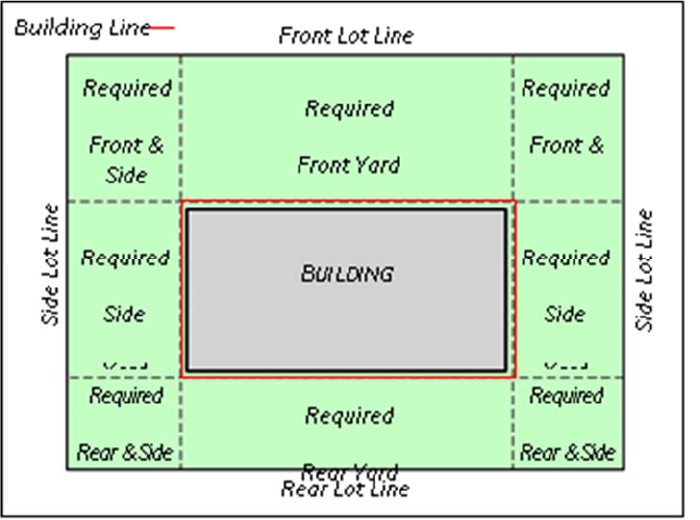
3
multi‐unitresidentialbuilding,inaccordancewithapplicablebuilding
restrictionlines,covenants,platnotations,andsetbacks,ifany.
*BuildableAreaGraphic
SECTION2.05‐COASTALAREAS
“Coastal Areas” means areas which border on bays or estuaries or other
waterways subject to tidal action which are subject to possible flooding or
increasedfloodlevelsbecauseoftidalaction,hurricanesurgeorrisingwater
duetostorms,hurricanesortsunamis.A“coastalarea”is
notnecessarilyina
“V”Zone.Incaseswherethereisaquestionasto whether anareaisacoastal
area,theHarrisCountyEngineeringDepartment shallreferto theFEMAFlood
InsuranceStudy.
SECTION2.06‐CONDUIT
A“Conduit”isanyopenorcloseddeviceforconveyingflowingwater.
4
SECTION2.07‐COUNTYENGINEER
“County Engineer” means the holder of the statutory position of the County
EngineerforHarrisCountyortheemployeedesignatedbytheCountyEngineer
toperformataskrequired bytheseRegulations.
SECTION2.08‐CURBANDGUTTERSECTIONS
A“CurbandGutterSection”isafullwidthconcretepavementwithcurb,either
doweledonsix‐inch(6”)curbsordoweledfour‐inch(4”)bytwelve‐inc h (12”)
curbormonolithiccurbandguttersectionsforasphaltconcretepavement.
SECTION2.09‐DESIGNSTORMEVENT
“Design Storm Event” means the rainfall intensity upon which the drainage
facilitywillbesized.Referencestorainfallconditionsinthesespecifications
shallapplyto“TechnicalPaperNo.40,U.S.WeatherBureau”,publishedbythe
U.S.DepartmentofAgriculture,SoilConservation Service.
SECTION2.10‐DRAINAGEAREAMAP
“DrainageAreaMap”meanstheareamapofawatershed,whichissubdivided
toshowtheareaservedbyeach subsystem.
SECTION2.11‐ELEVATION
“Elevation”meansheightabovemeansealevel.TheNorthAmericanVertical
Datum (NAVD) of 1988 (2001 Adjusted ) shall be used.Any future studies
changingtheFloodInsura nc eRateMap(FIRM),whichisreferencedtoalater
re‐levelingoftheverticalcontrolsystemshallbeusedwheneverarevisedFIRM
becomeseffective.
5
SECTION2.12‐EXTREMEEVENT
“ExtremeEvent”meansarainfallevent,whichexceedstheDesignStormEvent
up‐to and including the 100‐year frequency resulting in surcharge of the
underg round stormsewersystemandoverlandsheetflow.
SECTION2.13‐FEMA
“FEMA”meanstheFederalEmergencyManagementAgency.
SECTION2.14.a.–FLOODPLAIN
EASEMENT
“FloodplainEasement”meansthearea ofaresidentiallotshownonafinal
platthatis withinthe10 0‐yearfloodplainasdeterminedbythecurrentFlood
Insu ra nc eRateMap(FIRM).TheFloodplainEasementwillprovideno t ic e that
theresidentiallotissubjecttospecia l developmentandpermitting
requirements
bylocal governmentsimplementingfloodhazardarea
regulationsaspartofafloodmanagementprogramdevelopedincompliance
withtheNationalFlood Insuranc eProgramorTexasWater CodeSection
16.315.TheFloodplainEasementencu mbersthatportionofa“residentiallot”
thatmaybeusedforresidentialpurposeswhichmaybefloodproneorina
floodhazard areabasedonthecurrentFIRM.Improvementsconstructedor
placedinaFloodplainEasement,includingsing le ‐familyandmulti‐family
dwellingunits,maybesubjectto additionalfloodplainmanagement
regulations.”
SECTION2.14‐GEOTECHNICALENGINEER
A“GeotechnicalEngineer”isalicensedengineer withintheStateofTexa swho
worksforacompanyregisteredintheStateofTexasthathasbeenaccredit ed
by the American Association for Labo rato ry Accreditation (A2LA) in
geotec h n ical testing.
SECTION2.15‐HCFCD
“HCFCD”meanstheHarrisCountyFloodCont ro lDistrict.
6
SECTION2.16‐HYDRAULICGRADELINE
“HydraulicGradeLine”meansthelinerepresentingthepressureheadavailable
atanygivenpo intwithinthedrainagesystem.
SECTION2.17‐IN‐FILLDEVELOPMENT
“In‐fillDevelopment” means the development of opentracts ofland in areas
where the storm drainage infrastructure is alread y in place and takes
advantageoftheexist in g infrastructureasadrainageoutlet.
SECTION2.18–LATENTDEFECTS
“Latent Defects” means a defect or condition of construction which does not
complywiththeconstructiondocumentsordesignsintentwhichisgenerallya
hidden or concealed defect which cannot be discovered by reasonable or
customary inspection, examination or observation at either the time of
constructionorsubstantialcompletion,butwh ic hmanifestsovertime.
SECTION2.19–LOT
ForthepurposeoftheseregulationsthetermLotmeansanyplattedlot,parcel,
orreserve.
SECTION2.20‐MEANSEALEVEL
“Mean Sea Level” means the average height of the surface of the sea for all
statesofthetideaswasestablishedbytheUnitedStatesCoastalandGeodetic
Surveyin1929.
SECTION2.21‐PERSON
“Perso n” includes any individual or group of individuals, corporation,
partnership, association, or any other organized group of persons, including
StateandLocalgovernmentsandagenciesthereof.
7
SECTION2.22‐RAINFALLFREQUENCY
“Rainfall Frequency” means the probability of a rainfall event of defined
characteristicsoccurringinanygivenyear.Inform at ion onrainfallfrequency
is published by the National Weather Servic e.For the purpose of storm
drainagedesign,thefollowing frequenciesareapplicable:
1. 2‐year frequency – a rainfall intensity having a 50% probability of
occurrenceinanygivenyear,ornominallylikelytooccuronceeverytwo
years.
2. 3‐year frequency – a rainfa ll intensity having a 33% probability of
occurrence in any given year, or nominally likely to occur once every
threeyears.
3. 5‐year frequency – a rainfall intensity having a 20% probability of
occurrenceinanygivenyear,ornominallylikelytooccuronceeveryfive
years.
4. 10‐year frequency – a rainfall intensity having a 10% probability of
occurrenceinanygivenyear,ornom inallylikelytooccu ronceeveryten
years.
5. 25‐year frequency – a rainfa ll intensity having a 4% probability of
occurrence in any given year, or nominally likely to occur once every
twenty‐fiveyears.
6. 100‐year frequency – a rainfall intensity having a 1% probability of
occurrenceinanygivenyear,ornominally
likelytooccuronceev eryone
hundredyears.
7. 500‐year frequency – a rainfall intensity havi ng a 0.2% probability of
occurrenceinanygivenyear,ornominallylikelytooccuronceeveryfive
hundredyears.
SECTION2.23‐REDEVELOPMENT
“Redevelopment”meansachangeinlandusethatalterstheimperviouscover
fromonetypeofdevelopmenttoeitherthe
sametypeoranothertypeandtakes
advantageoftheexist in g infrastructurein placeasadrainageoutlet.
8
Section2.24‐RESIDENTIALLOT
“Residentiallot”meansalot,parcelorreservewithinasubdivisiononwhich
a single‐fa mily dwelling unit or a multi‐family residential structure may be
lawfully constructed, located or placed, including a site built home, modular
home, manufa ctured home, townhouse, duplex or a multi‐unit residential
building.
SECTION2.25‐ROADSID EDITCHSECTIONS
“Roadside Ditch Sections” are ditch sections adjacent to either full width
reinforced concretepavementorasphalticconcretepavement.
SECTION2.26‐SHEETFLOW
“SheetFlow”meanstheoverlandstormrunoffthatisnotconveyedinadefined
condu it and is typically in exces s of the capacity of the conduit or roadside
ditch.
SECTION2.27‐SUBDIVISION
“Subdivision”meansadivisionofanytractoflandintotwo(2)ormoreparts
forthepurposeoflayingoutanysubdivisionoranytractoflandoranyaddition
to the city, or for laying out suburban lots or buildings lots, or any lots, and
streets,alleysorpartsofotherportionsintendedforpublicuseortheuseof
the purchasers or owners of lots fronting thereon or adjacent thereto.A
subdiv isionincludesre‐subdivision(replat),butitdoesnotincludethedivision
oflandinparcelsor
tractsoften(10)acresormoreandnotinvolvinganynew
streets,alleysoreasements ofaccess.Thisdefinitionisbasedoncurrentstate
statutesandshouldthestatutesbechangeditsnewdefinitionwouldgovern.
SECTION2.28–SUBSTANTIALMODIFIC ATION
Substantialmodificationshallmeanchangestotheapprovedplans,
plat,and/or
drainage report or change of use that will increase imperv ious cover, or the
volume and/orpeak discharge of the stormwater runoff from portio ns of, or
thewholeoftheprojectoranyotherchangethatwouldaffectthevolumeor
peakdischargeofstormwater runoffthatwouldcauseadverseimpactstooff‐
siteproperties.
9
SECTION2.29‐UNINCORPORATEDAREA
“Unincorporated Area”meansthe area in HarrisCounty, Texas,which isnot
within an incorporated area of a city, town, and village or within the
“jurisdictionofthePortofHoustonAuthorityofHarrisCounty,Texas,”being
thatareawithin2,500feetof thethreadoftheHoustonShipChannelthatis
eligible for limited purpose annexation pursuant to Texas Local Governme nt
Code§43.1 36 .
10
SECTION3‐GENERALPROVISIONS
SECTION3.01‐ADMINISTRATIONBYTHECOUNTYENGINEER
TheCountyEngineerisresponsiblefortheadministrationoftheseRegulations,
approval of plans required by these Regulations, and enforc em en t of these
Regulations and maintain ing proper records.The County Engineer may
delegate particular authority given to the County Engineer under these
RegulationstoanothermemberoftheHarrisCountyEngineeringDepartment
andanactionbysuchdelegatedpersonundersuchgrantedauthorityshallbe
deem ed anactionoftheCount yEngineer.
SECTION3.02‐RESPONSIBILITYOFOTHEROFFICIALS
Under these regulations the Harris County Engineering Department is
responsible for all administrative decisions, determinations and duties.The
HarrisCountyEngineeringDepartmentmayseekandsecuretheassistanceof
otherofficialsofHarrisCountyandoftheHarris CountyFloodControl District
in making its decisions, determinations and in performing duties but is not
requiredtoconformtotherecommendationsofothers.
11
SECTION4‐ADMINISTRATIVEPROCEDURES
FORTH EREVIEWOFPLATS
SECTION4.01‐APPROVALREQUIRED
AlldevelopmentwithintheunincorporatedareasofHarrisCountyisprohib it ed
withoutfirstsecuringapprovedplansorplat,ifrequired,and adevelopment
permit issued under the Regulations of Harris County, Texas, for Floodplain
Management.
SECTION4.02‐ENFORCEMENT
Itshallbeunlawfulforanypersontolayout,subdivideorplatanylandinto
lots,blocks,tractsorstreetswithintheunincorporatedareaofHarrisCounty
ifthelandhasnotbeenlaidout,subdividedandplattedinaccordancewith
theserulesandregulations.
SECTION4.03‐PLATCRITERIA
Fortractsoflandlocatedwithintheextraterritorialjurisdiction(ETJ)ofan
incorporated city or town and subject to the jurisdiction of the Planning
Commission or other governing body of that city or town, general
subdivision and layout requirements as established by the applicable
Commissionorothergoverningbodyshallapply.Inthecircumstancewhere
anyrule,regulation,procedureorpolicylawfullyorofficiallyadoptedbythe
governing body of any city or town exercising jurisdiction within its
extraterritorialjurisdictionislessrestrictivethanthatcontainedherein,the
standards adopted by these rules and regulations and applicable State law
shallapply.
For all other tracts not located within a municipality’s extraterritorial
jurisdictionor forwhich themunicipality hasissueda writtencertification
statingthat aplat is notrequiredtobe filedfor thatsubdivision of land in
accordance with Chapter 212 of the Texas Local Government Code, the
followingrules
anddesignrequirementsshallapply:
1. Lotsshallbe of sufficient acreage to meetminimumrequirementsfor
on‐site sewage service per TCEQ Chapter 285.4 Facility Planning
regulations,unlessservedbypublicwaterand/orsewage.
12
2. Publicroadrights‐of‐wayshallbeaminimumfiftyfeet(50’)inwidth
andinconformance withtheGeometricDesignGuidelinesas adopted
byHarrisCountyCommissioners’Court.
3. Abuildingsetbacklineofnotlessthantwenty‐fivefeet(25’)fromthe
roadright‐of‐wayshallbeimposedontractsintendedforconstruction
ofasingle‐familystructure orstructures. However, twenty‐foot(20’)
building setback lines will be permitted for single‐family residential
lotsoncul‐de‐sacsandknuckles.Aten‐foot(10’)buildingsetbackline
will be permitted on side lots of single‐family residential lots. A
buildingsetbacklineofnolessthantenfeet(10’)shallbeimposedon
allothertracts.Thesesetbacksmaybemodifiedifsuch modifications
complywithCountyPlanningCriteria.
4. Construction of road and appurtenant drainage facilities shall be in
conformance with specifications as set out in these rules and
regulations.
5. Surveyorshalldelineatethelimitsofthe100‐yearfloodplainonafinal
plat and designate a Floodplain Easement on that portion of all
residential lots where the buildable area is within the 100‐year
floodplain.
6. Financial Surety: A cash deposit, bond, or letter of credit made in
accordance with the Texas Local Government Code 232.004 or
232.0045andtheseregulations.
Foralltractsnotlocatedwithinamunicipality’sextraterritorialjurisdiction,
thoroughfarealignmentandright-of-way(ROW)widthplanningshallfollow
the requirements specified in the Thoroughfare Amendment Study for
Unincorporated and
Non-ETJ Areas of Harris County, Texas as adopted by
HarrisCountyCommissioners’Courtandanysubsequentrevisionsthereto.
SECTION4.04‐EXCEPTIONS
Exceptions to platting requirements are established in Section 232.0015 of
theTexasLocalGovernmentCode.Abriefdescriptionfollows:
1. A countymay notrequire theownerof
atract oflandlocated outside
thelimitsofamunicipalitywhodividesthetractintotwoormoreparts
tohaveaplatofthesubdivisionpreparediftheownerdoesnotlayout
apartofthetractasstreets,alleys,squares,parks,orotherpartsofthe
13
tract to be dedicated to public use or for use of lots fronting on or
adjacenttothe streets,alleys,squares,orotherparts,andthelandis
to be used primarily for agricultural use or farm, ranch, wildlife
management,ortimberproduction.
2. A countymaynotrequire theownerof a tractoflandlocated outside
the limitsof amunicipality whodivides the tract of landinto fouror
fewer partsand doesnot lay out a partof the tractas streets,alleys,
squares,parks,orotherpartsofthetracttobededicatedtopublicuse
orforuseoflotsfrontingonoradjacenttothestreets,alleys,squares,
orotherpartstohaveaplatofthesubdivisionpreparedifeachofthe
lotsistobesold,given,orotherwisetransferredtoanindividual who
is related to the owner within the third degree
by consanguinity or
affinityperChapter573,GovernmentCode.Ifthetractistransferred
toanotherwhoisnotrelatedwithinthethirddegreebyconsanguinity
or affinity, then the platting requirements of these regulation shall
apply.
3. A countymaynot require theownerof a tractof land
locatedoutside
thelimitsofamunicipalitywhodividesthetractintotwoormoreparts
to have a plat of the subdivision prepared if all the lots of the
subdivisionaremorethan10acresinareaandtheownerdoesnotlay
outapartofthetractasstreets,alleys,squares,parks,orotherparts
ofthetracttobededicatedtopublicuse orforuseoflotsfrontingon
oradjacenttothestreets,alleys,squares,orotherparts.
4. Acountymaynotrequiretheownerofatractoflandlocatedoutsidea
municipalitytohaveaplatofthesubdivisionpreparedifallthelotsare
soldtoveteransthroughtheVeterans’LandBoardprogram.
5. A county may not require the owner of a tract land to have a plat
prepared if the owner is the state or any state agency, board, or
commissionorownedbythepermanentschoolfundsofthestateunless
the subdivisionlays out apart of thetract as streets, alleys,squares,
parks,orotherpartsofthetracttobededicatedtopublicuseorforuse
oflots frontingon oradjacentto thestreets,alleys,squares,or other
parts.
6. A countymay notrequirethe ownerof atractof land locatedoutside
thelimitsofamunicipalitywhodividesthetractintotwoormoreparts
tohaveaplatofthesubdivisionpreparediftheownerofthelandisa
politicalsubdivisionofthestate,thelandissituatedinthefloodplain,
andthelotsaresoldtoadjoininglandowners.

14
7. Acountymaynotrequiretheownerofatractoflandoutsidethelimits
ofamunicipalitywhodividesthetractintotwopartstohaveaplatof
thesubdivisionpreparediftheownerdoesnotlayoutapartasstreets,
alleys, squares, parks, or other
parts of the tract to be dedicated to
publicuseorforuseoflotsfrontingonoradjacenttothestreets,alleys,
squares,orotherpartsandonepartistoberetainedbytheowner,and
the other new part is to be transferred to another person who will
furthersubdividethetractsubjecttotheplatapprovalrequirements.
8. A countymay notrequire theownerof atract oflandlocatedoutside
thelimitsofamunicipalitywhodividesthetractintotwoormoreparts
tohaveaplatofthesubdivisionpreparediftheowner
doesnotlayout
apartofthetractasstreets,alleys,squares,parks,orotherpartsofthe
tract to be dedicated to public use or for use of lots fronting on or
adjacenttothestreets,alleys,squares,orotherpartsandallpartsare
transferredtopersonswho
ownedanundividedinterestintheoriginal
tractandaplatisfiledbeforeanyfurtherdevelopmentofanypartof
thetract.
SECTION4.05‐REVIEWPROCEDURES
MunicipalitiesinHarrisCountyexercisingtheirextraterritorialjurisdiction
(“ETJ”)intheunincorporatedareaofHarrisCountyhavedevelopedspecific
and unique proceduresin processingplats.The procedures outlined below
shallbefollowedforsubmittingaplatapplicationandplattoamunicipality
andHarrisCountyforreviewandcomment.Proceduresforsubmittingaplat
applicationandplatforpropertylocatedintheunincorporatedareaofHarris
Countyarealsoincludedbelow.Forallplats
withinamunicipality’sETJ,use
the dedicatory language as promulgatedby that municipality. Forplats not
located in a municipality’s ETJ, required dedicatory language and all plat
certificate requirements are set forth in Section 4.07 and in Appendix “A”
respectively.
Plats Within A Municipality’s ETJ.For plats of property located in the
unincorporated area of Harris County and the ETJ of a municipality, the
ownerofthetractbeingplattedshallsubmitcopiesoftheplat,alongwitha
platapplication,tothemunicipalityexercisingETJforreviewandcomments,
atwhichtimethemunicipality maybeginitsreviewoftheplat.Itshallbe
theresponsibilityofthe ownerof thetract beingplatted toensurethat the

15
HarrisCountyEngineeringDepartmentandtheHarrisCountyFloodControl
Districtalsoreceivecopiesoftheplat.
Plats NotLocated ina Municipality’sExtraterritorial Jurisdiction.For plats
ofpropertylocatedexclusivelyintheunincorporatedareaofHarrisCounty
andnotintheextraterritorialjurisdictionofanymunicipality,theownerof
the tract being platted shall simultaneously submit copies of the plat
applicationandtheplattotheHarrisCountyEngineeringDepartmentandthe
Harris County Flood Control District, at which time they will begin their
reviewoftheplat.
All Plats. Upon Harris County Engineering Department’s receipt of the
original mylar of the plat fully executed by the owners and, as applicable,
approvedbytheappropriatePlanningCommissionorgoverningbody,along
withtherequireddocumentationdescribedin“RecordationRequirements”in
Section 4.06 below, Harris County Engineering Department will begin its
reviewoftheplat.
If the plat does not meet all the requirements of Section 4 of these
Regulations, the Harris County Engineering Department will provide its
commentstotheownerofthetractbeingplattedinaccordance withSection
232.0025 of the Texas Local Government Code.If the plat meets all the
requirementsset forthin Section4of theseRegulations,the HarrisCounty
Engineer will sign it.The plat will then be placed on the next available
Commissioners’Courtagendaforapproval.
Once approved by HarrisCounty Commissioners Court (“Court”), the Court
willsendtheplattotheofficeoftheHarrisCountyClerkforrecordation.The
HarrisCountyClerkshallcalculatetherequiredrecordingfeesandnotifythe
applicantorapplicant’sdesigneeofsame.Uponreceiptofsuchfees,theplat
willbefiledandrecordedintheOfficialPublicRecordsofRealPropertyand
MapRecordsofHarrisCounty,Texas.
SECTION4.06‐RECORDATIONREQUIREMENTS
The following documentation is required to be submitted along with the
original mylar of the plat that is to be reviewed by the Harris County
EngineeringDepartment, submittedto HarrisCounty Commissioners’Court
for approval, and filed with the Harris
County Clerk.Harris County will
acceptforrecordationonlythoseplatsprintedonthefrontsideofthemylar
orotherreproduciblematerial.
16
1. Atitlereport,oropinion,titlepolicyorcertificateorletterfromatitle
company authorized to do business in the State of Texas must be
providedindicatingownershipoftheproperty,allliensagainstsame,
and any existing easements. The title report shall not have been
executedmore thansixty (60) days priorto the time the final plat is
received by the Harris County Engineering Department and may
requireupdatingattherequestofHarrisCountypersonnel.Ownersof
propertylocatedwithintheplatmusteithersigntheplatorexecutean
Owner’s Ratification of Platdocument, as promulgated by theCounty
Engineer.Furthermore,liensagainstthepropertyshallbesubordinate
to all dedication of streets, rights‐of‐ways, easements and terms and
conditionsreferredtoontheplat.Lienholdersmusteithersigntheplat
or execute a Lienholder’s Subordination to Dedication document as
promulgated by the Harris County Engineer.See Appendix “B” for
notaryformats.
2. An original tax certificate from the tax collector of each political
subdivision in which the property is located showing that all taxes
owedto theCounty,School District, Utility District, and/orany other
politicalsubdivisionhavebeenpaidinfull.Iftheplatorreplatisfiled
afterSeptember1ofayear,theplatorreplatmustalsohaveattached
to it a tax receipt issued by the collector for each taxing unit with
jurisdiction of the property indicating that the taxes imposed by the
taxingunitforthecurrentyearhavebeenpaidor,ifthetaxesforthe
currentyearhave not beencalculated, a statement fromthe collector
forthetaxingunitindicatingthatthetaxestobeimposedbythattaxing
unitforthecurrentyearhavenotbeencalculated.Ifthetaxcertificate
forataxing unit
doesnotcoverthe precedingyear,theplatorreplat
must also have attached toit atax receiptissued by the collector for
thetaxingunitindicatingthatthetaxesimposedbythetaxingunitfor
theprecedingyearhavebeenpaidinfull.
This requirement does not apply
to the extent of the applicability of
exceptionsinTexasPropertyCode12.002(e)inregardtocertainreal
propertyacquiredbywillorinheritanceortocertainpropertyacquired
byeminentdomain.
3. A completed Utility Service Plan, as promulgated by the County
Engineer,shallbesubmitted.Innocaseshallaplatberecordedprior
toassurancesbeinggiventhatallapplicableStateandCountyreviews
and/orpermit(s)havebeenobtained.
17
4. A letter from the County Tax Assessor‐Collector certifying that the
nameofthesubdivisiontobepresentedtoCommissioners’Courtisnot
in conflict with any other previously recorded subdivision.This
requirementapplies tothe firstsection ofmulti‐sectionsubdivisions,
all re‐plats, and amending plats and is
not applicable to street
dedicationplatsdesignatedbyastreetname.
5. ApprovedplansaretobeonfilewiththeEngineeringDepartmentatthe
time the plat is submitted to Commissioners’ Court.However, if the
tractoflandisbeingplattedtocreatereservesforthepurposeofsale
only and there are no immediate plans for construction of
improvementsonsaidreserves,thenanoteshallbeplacedontheface
oftheplatstating:
“Sitedrainageplansforthefuturedevelopmentofthisreservemust
be submitted to the Harris County Flood Control District and the
HarrisCountyEngineeringDepartment.”
6. Aletter,statementorotherinstrumentfromtheownerofanyprivately
ownedeasementwithintheplatboundarieswheresucheasementisto
be crossed by streets (either public or private) or public utility or
drainageeasements,statingthattheownerofsucheasementapproves
such crossing of the private easement for the purposes intended and
depicted on the plat, if such approval is not granted in the original
documentconveyingtheeasement.
7. AplatreviewfeeasestablishedbyCommissioners’Courtisrequired
tobesubmitted.
8. For plats of lots and/or reserves requiring
plan review and not
dedicating any public rights‐of‐way, a non‐refundable administrative
feeisassessedintheamountof$10.00perlot.Reservesareassessed
a non‐refundable administrative fee of $20.00 per 100 feet of plat
boundary adjoining road right‐of‐way rounded to the next highest
incrementof$20.00.Payment ofadministrativefeesshouldbemade
payabletoHarrisCountyandareduepriortotheplatbeingpromoted
to Commissioners’ Court for action.Payment of administrative fees
mustbesubmittedwiththeFinancialSurety/AdministrativeWorksheet
validatedbythePlanningSection.

18
9. Forplatsproposingthededicationofapublicstreet(s)andconstruction
ofpavingandappurtenantdrainage,aFinancialSuretyisrequiredprior
toplatapprovalandshallbe:
A. MadepayabletoHarrisCounty,unlesscash;and
B. Inatotalamountbaseduponthefollowingschedule:
RESIDENTIALSUBDIVISIONS COMMERCIALANDSTREET
DEDICATIONSUBDIVISIONS
$50perlotwithaverageroad
frontagelessthan100feet.
$75per100feetofproposed
pavement.Thefeeshallbe
roundedtothenext100feet.
$75perlotwithaverageroad
frontage100feetorgreater.
*NOTE:
Theminimumfinancialsuretypostedinanycaseshallbe$2,500.00.
Includedisthenon‐refundableadministrativefeeof$10perlotfor
residentialsubdivisionsor$20per100ft.ofpavementincommercial
andstreetdedicationsubdivisions.
10. For properties being platted in the unincorporated areas of Harris
County,wherethereisnotExtraterritorialJurisdictionbeingexercised
forwaterandsewerfacilities,thefollowingrequirementsforwaterand
sewagefacilitiesapply:
A. Thedrinkingwatersupplyshallmeettheminimumrequirements
establishedbyChapter341oftheHealthandSafetyCodeandany
other minimum requirements established by the Texas
Commission on Environmental Quality applicable to drinking
water.
B. Any onsite sewerage disposal systems shall be constructed in
accordancewithChapter366oftheHealthandSafetyCodeand
the Revised Rules of Harris County for On‐Site Sewerage
Facilities.
19
C. Any sewerage facility other than a properly permitted onsite
sewage facility shall be constructed and operatedunder a valid
permit issued by the Texas Commission on Environmental
Quality.
11. Ifapropertylieswithinthe100‐yearfloodplainasshownonthemost
recent FIRM adopted by Harris County, the floodplain must be
delineated graphically on the final plat.Surveyor shall designate a
Floodplain Easement on that portion of all residential lots where the
buildable area of those residential lots is within the 100‐year
floodplain.Refer to Section 4.08 for floodplain easement dedicatory
language.
12. Additionalinformationmaybe
requiredby theEngineeringDepartment
to clarify or support any of the aforementioned recordation
requirements.
SECTION4.07–FLOODPLAINEASEMENTSONPLATS
Where the buildable area of a lot, parcel or reserve is intended for
single family or multi‐family residential unitsand isproposed tobe placed
withinthemapped100‐yearfloodplain,thefinalplatshallshowthatportion
of the 100‐year floodplain as a “Floodplain Easement” on the plat.The
FloodplainEasementshallbeillustratedon thefinalplatmapas congruent
withthelimitsofthe100‐yearfloodplainwithintheplatboundary fromthe
mostrecentFIRMandshallbeincludedasadedicationbythepropertyowner
usingthelanguagebelow.
1) SampleFloodplainEasement
”AFloodplainEasementisherebyestablishedoverthatportionofthe
effective100‐yearfloodplainareaasdelineatedfromFIRMPANELNo.
XXXX dated XXXXwithin the boundary of thisfinal plat, the limits of
whichimpactthebuildableareasofresidentiallots,whollyorpartially,
and within such area is prone to flooding.(*See attached sketch.)
Construction of any type of residential housing within a Floodplain
Easement is subject to additional flood hazard area regulations.A
Floodplain Easement may be abandoned by Harris County
Commissioners Court if the buildable area of a residential lot is
determinedtobeoutsidethe100‐yearfloodplainbysubmittingCounty
Engineer’s Form 1226, with the applicable documentation and fee, to
theOfficeoftheCountyEngineer.

20
2) AbandonmentofFloodplainEasement
A Floodplain Easement may be abandoned by using following
procedure:
a) CompleteHarrisCountyEngineerForm1226includingprovidingproof
thatthebuildableareaofaspecificresidentiallot(s)hasbeenremoved
from the mapped 100‐year floodplain by a letter of map revision
(LOMR)oraletterofmapamendment(LOMA).
b) Submittheapplicablefee,tobethesameasapermitforasinglefamily
residenceoutsidethefloodplain,currently$75.00.
c) Once received, reviewed and approved by the Office of the County
Engineer, a Court Order will be submitted to Commissioners Court,
abandoningtheFloodplainEasementontheresidentiallot(s).
d) Once approved by Commissioners Court the County Engineer will file
theabandonmentintheRealPropertyRecordsofHarrisCounty.
SECTION4.08‐ DEDICATORYLANGUAGEANDCERTIFICATESREQUIRED
ON PLATS OF PROPERTY LOCATED IN THE
UNINCORPORATEDAREAOFHARRISCOUNTY
1. Dedicatorylanguageontheplatsmustincludethefollowingparagraphs
andcanbefoundinAppendix“A”totheseregulations:
A. “FURTHER, Owners do hereby dedicate to the public a strip of
landfifteen(15)feetwideoneachsideofthecenterlineofany
andallbayous,creeks,gullies,
ravines,draws,sloughs,orother
natural drainage courses located in said plat, as easements for
drainage purposes, giving the City of (name of city), Harris
County, or any other governmental agency, the right to enter
upon said easement at any and all times for the purpose of
construction and maintenance of drainage facilities and
structures.”;
B. “FURTHER,Ownersdoherebycovenantandagreethatallofthe
property within the boundaries of this plat andadjacent to any
drainageeasement,ditch, gully, creekornatural drainageways
shall hereby be restricted to keep such drainage ways and
21
easements clear of fences, buildings, planting and other
obstructions to the operations and maintenance ofthe drainage
facilityandthatsuchabuttingpropertyshallnotbepermittedto
draindirectlyintothiseasementexceptbymeansofanapproved
drainagestructure.”;and
C. “FURTHER,Ownerscertifyandcovenantthattheyhavecomplied
with or will comply with existing Harris County Road Law,
Section 31‐C as amended by Chapter 614, Acts of 1973, 63
rd
Legislatureand all otherregulations heretoforeonfilewiththe
HarrisCountyEngineerandadoptedbytheCommissioners’Court
ofHarrisCounty.”
2. Additionalcertificationontheplatmustindicatethefloodplainstatus
of the buildable areas on “residential lots” on the plat, referring to the
applicableFloodInsuranceRateMappanelandeffectivedate.
A. BuildableAreasOutsidetheFloodplain:
“I, ___________________, a Registered Professional Licensed
SurveyorintheStateofTexas,doherebycertifythatthebuildable
areas for all residential lots are outside [or, are proposed to be
outside,basedonengineeringplansandspecificationssubmittedto
theCountyEngineersOffice,]the100‐YearFloodplainasshownon
FederalInsuranceRateMapPanelNo.[insertpanelnumber]dated
[insert effective date of map]. This certification is based solely on
plotting boundaries from the FIRM Map, and no technical analysis
wasconducted.”
B. BuildableAreasintheFloodplain
“I, ____________________ a Registered Professional Licensed
SurveyorintheStateofTexas,doherebycertifythatthebuildable
areas for all or some of the residential lots are located within the
100‐yearfloodplainasplottedfromtheFederalInsuranceRateMap
PanelNo.[insertpanelnumber]dated[inserteffectivedate
ofmap]
andaresubjecttoflooding.The100‐yearfloodplainisafloodhazard
area prone to flooding, and subject to additional floodplain
managementregulations.”
3. Floodplaineasementdedicatorylanguagemustbeshownontheplatif
aFloodplainEasementisrequiredinaccordancewithSection4.07Floodplain
Easements.
22
”A Floodplain Easement is hereby established over that portion of
the effective 100‐year floodplain area as delineated from FIRM
PANELNo.XXXXdatedXXXXwithintheboundaryofthisfinalplat,
the limits of which impact the buildable areas of residential lots,
whollyorpartially,andwithinsuchareais
pronetoflooding.(*See
attached sketch.) Construction of any type of residential housing
within aFloodplain Easement issubject to additionalflood hazard
area regulations.A Floodplain Easement may be abandoned by
Harris County Commissioners Court if the buildable area of a
residential lot is determined to be outside the
100‐year floodplain
by submitting County Engineer’s Form 1226, with the applicable
documentationandfee,totheOfficeoftheCountyEngineer.
4. ApprovedCertificateLanguagemaybefoundinAppendix“A”tothese
regulations.
SECTION4.09–AlternativePlanningCrit eria
HarrisCountyAlternatePlanningCriteriaforSubdivisionsandPlattingshallbe
adhered to when more stringent than municipality whose extraterritorial
jurisdiction includes any part of unincorporated Harris County. Chapter 42‐
Section 3 of the City of Houston’s Ordina nc e codifies this requirement;
however,theCountyPlanningCriteriaappliestoallcity’sETJareas.
ProjectsfollowingthebelowCountyPlanningCriteria,aredeemedtobemore
stringentandsaidcriteriasupersedescriteriaofanyCity’sETJrequirement.To
preventconfusion, anyplatusingtheCounty’smorestringentcriter ia ,willbe
reviewedbytheCountyfirst,andiffoundtomeettheCountyCriter ia ,aletter
willbeissuedbytheCountyEngineer
statingthatfactforusebytherespective
City.
23
CountyPlanning Criteria
(Thesepagesleftintentionallyblank)
24
SECTION5‐ADMINISTRATIVEPROCEDURESFORTHE
REVIEWOFCONSTRUCTIONPLANS
SECTION5.01‐SUBMITTALPROCEDURES
1. ApreliminarysetofplansshallbesubmittedtotheCountyEngineerfor
reviewalongwithaCountyissuedRoutingSlip.Uponreview,thePlans
willbereturnedtotheconsultantwithanynecessarycomments.Plans
may be reviewed electronically by submitting through the online
systemusingtheappropriateapplication.
2. Uponaddressingallthecomments,afinalreviewwillbeconductedby
submittingthemarked‐uppreliminaryset,areproducibleset,andthe
routing slip to the County Engineer.The plans will be approved or
additionalcommentswillbemadeandthesetsreturned.
SECTION5.02‐CONSTRUCTIONPLANS‐GENERAL
For all construction plans submitted to the Harris County Engineering
Departmentpursuanttotheseregulations,thefollowingrequirementsshall
apply:
1. AProfessional Engineer,licensed inthe Stateof Texas,is requiredto
seal,dateandsigneachsheetoftheplansinaccordancewithrulesset
forthbytheTexasStateBoardforProfessionalEngineers.Thesealmust
reproduceonallsheets.
2. Acoversheetshallberequiredforallprojectsinvolvingthreeormore
planandprofilesheets.Allplansheetnumbersshouldbe
includedon
thecoversheetorareamap.Avicinitymapshouldalwaysbeincluded
toshowtheprojectlocation.
3. Plansforstreetand/orpublicimprovementsshallbestandardtwenty‐
two inch by thirty‐four inch (22” x 34”) overall dimensions for all
designinrights‐of‐wayor
easements.Siteplansmaybesubmittedon
largersheetswhenpractical.
4. Plans submitted for Harris County Engineering Department approval
shallbeonareproduciblematerial.
25
5. ANortharrowisrequiredonallsheetsandshouldbegenerallyoriented
eitherupwardortotheright.
6. All projects shall be tied to the datum adjustment that matches the
FIRMsorthemostcurrentdatumavailableincoastalareas.Equations
may be used to translate other datum adjustments to the required
adjustment.
7. Graphic standards for construction plans submitted shall be in
accordancewiththoseoutlinedinAppendix“C”totheseregulations.
8. Ifthe propertyliesbelow thebasefloodlevel,thefloodplain mustbe
delineatedgraphicallyonallplansheets.
SECTION5.03‐PLANLAYOUTREQUIREMENTS
Plans submitted to the Harris County Engineering Department pursuant to
theseregulationsshallhavethefo llo wingitems:
1. General construction layouts shall be submitted for all paving and
utilityprojectsinvolvingmorethanthreeplanandprofilesheets.For
thepurposeoffulfillingthisrequirement,pavinganddrainagelayouts
may be combined and water and sanitary sewer layouts may be
combined.
2. A drainage area map shall be submitted and shall include drainage
computationswithdrainageareaandstormwaterflowlabeled.
3. A lot grading plan shall be submitted for residential lots on which
earthworkisproposedthatwillchange
thenaturaltopography.
4. Adrawingshowingexistingnaturalcontoursatone‐foot(1’)intervals
ofthelandtobedeveloped.
5. A graphical sheet index shall be included on the general construction
layoutoronaseparateindexsheetshowingtheplanandprofilesheet
locationandsheetnumber.
6. Matchlinesinappropriatelocationsandnotintheintersectionsoftwo
streetsorcul‐de‐sacknucklesshallbeprovided.
7. If a roadway exists where plans are being prepared to improve the
26
roadway or construct new pavement or to construct a utility, this
roadwayshouldbelabeledastoitsexistingwidth,typeofsurfacingand
basethicknessifavailablewithoutdestructionofpavement.
8. Allimprovementsshall belabeled as “Proposed”or“Existing”in both
Planand ProfileViews.
9. Include a fire lane designed in accordance with the current Harris
CountyFireCodeforapprovalwithallcommercialsiteplans.
10. Includealandscapeplandesignedinaccordancewiththeseregulations
forapprovalwithallcommercialsiteplans.
SECTION5.04‐STANDARDDETAILSHEETS
For all construction plans submitted to the Harris County Engineering
Departmentpursuanttotheseregulations,thefollowingrequirementsshall
apply:
1. The Harris County standard paving and detail sheets shall be
incorporated by reference in the project specifications and by
constructionnotesontheplans.
2. The details of special structures not covered by approved standard
drawings, such as stream and gully crossings, special manholes, etc.,
shouldbeincluded.Thedetailsshallbedrawnonthedetailsheetswith
thehorizontalandverticalscalesequal.
3. The Harris County Engineering “Express Review Sheet” shall be
submitted with each set of plans and be completed including Harris
CountyAppraisalDistrictaccountnumber.
SECTION5.05‐STANDARDNOTEREQUIREMENTS
Thefollowingstandardnotesshallbeincludedintheplans,whereapplicable,
asspec ified below:
1. AllprojectsshallincludethenotesinAppendix“D”totheseregulations.
2. Allprojectsinvolvingpavingorutilitieslocatedinapublicright‐of‐way
27
shallincludenotesinAppendix“E”totheseregulations.
3. Allprojectsinvolvingesplanade openingsandturn lanesshallinclude
thenotesinAppendix“F”totheseregulations.
4. Allprojectslocatedwithinthe10%(10‐year)floodplain,the1%(100‐
year)floodplain,orthe0.2%(500‐year)floodplainshallincludenotes
inAppendix“G”totheseregulations.
SECTION5.06–SUPPLEMENTALREQUIREMENTS
Unless otherwise directed by the County Engineer, the following additional
requirementsshallbeincludedwiththeinitialsubmittalofpreliminaryplans
orpriorto finalplanapprovalassetforthb e lo w:
1. HarrisCountyFloodControlDistrictapprovalisrequiredpriortofinal
planapproval.
2. Harris County Toll Road Authority approval is required prior to final
planapprovalifprojectencroachesorimpactHCTRAright‐of‐way.
3. Texas Department of Transportation (TxDOT) approval is required
prior to final plan approval if project encroaches or impacts HCTRA
right‐of‐way.
4. Ifrequired,TrafficImpactAnalysisapprovalisrequiredpriortofinal
planapproval.
5. If project encroaches into a pipeline easement, approval from the
owneroftheeasementisrequiredpriortofinalplanapproval.
6. If utility connections are proposed, approval from the utility owner
verifyingcapacityisrequiredpriortofinalplanapproval.
7. If project encroaches into jurisdictional wetlands, approval from the
U.S.ArmyCorpsofEngineersifrequiredpriortofinalplanapproval.
8. Maintenance Agreements for non‐standard items located in Harris
Countyright‐of‐wayarerequiredpriortofinalplanapproval.
28
9. Harris County Capital Improvement Projects Division Interpose “No
Objection”letterforprojectsadjacentoraffectingcapitalprojectsare
requiredpriortofinalplanapproval.

29
SECTION6‐DRAINAGEREQUIREMENTS
SECTION6.01‐DRAINAGEPOLICY
1. DesignRequirements
A. The drainage criteria administered by Harris County and
complemented bytheCityofHoustonandtheHarrisCountyFlood
ControlDistrictCriteriafornewlydesignedareasprovidesstreet
drainage design at a 2‐year event frequency, and protects from
structuralfloodingatthe100‐yeardesignfrequency.Additionally,
inareasinoradjacenttomappedfloodplains,structuralprotection
isprovid ed for the 500‐yeardesign event,using thoseelevations
derived from the effective Flood Insurance Study (FIS).This is
accomplished with the application of various drainage
enhancements such as storm sewers, roadside ditches, open
channels,detentionandoverla nd(sheet)run‐off.
B. Recognizing that each site has unique characteristics that may
enhancetheopportunitytoprovideproperdrainage,theintentof
these criteria is to specify minimum requirements. These
minimums may be modified with prior consent of the Harris
CountyEngineeringDepartmentprovid ed thattheobjectiveforthe
minimumdrainagestandardsismaintained.
2. StreetDrainageDesign‐Streetpondingofshortdurationisanticipated
and designedto contributeto theoverall drainagecapability ofthesystem.
Storm sewers and roadside
ditch conduits are designed as a balance of
capacityand economics.These conduits are designed to convey less
intense,morefrequentrainfalls while attempting to allow traffic movement
duringtheseevents.When rainfalleventsexceedthecapacityofthestorm
sewersystem,theadditionalrun‐ off is intended to be
stored or conveyed
overland inamannerthatreducesthe threatoffloodingtostructures.
3. Flood Control Design – Harris County is a participant in the National
Flood Insu ra nc e Program.The flood insurance program attempts to
makefloodinsurance available at low cost by providing for measures that
reducethe
likelihoodofstructuralflooding.
4. Relationship to the Platting Process – The approval of storm drainage
systems, detention facilities, and flood channel improvements is a part of
thereview processforplanning andplattingofnewdevelopment.
30
SECTION6.02‐DESIGNREQUIREMENTS
Alldesignsofmajorthoroughfaredrainagefacilities,manholes,inlets,bedding
andbackfillshallmeettherequirementsofStandardSpecifications,Standard
DrawingsandHa rris County Regulations.
TheStandardSpecifications,StandardDrawings,HarrisCoun tyRegulations,as
wellasthemostrecentlyadoptedCityofHoustondesignguidelines,willapply
forallnon‐majorthoroughfareprojectslocatedwithinHarrisCountyandthe
CityofHou sto nETJ.Themoststringentdesigndetailsshallapplyintheevent
ofanydiscrepancy.
Note:With prior approval, products listed in the Harris County Special
Specif ication s8013maybeused .Alternativetypesofpipeproposed
forusein
stormsewerapplicationsmustreceivepriorapprovaloftheCountyEngineer.
1. Me thod ofDeterminingRunoff
A. ArearunoffshallbedeterminedusingtheRationalFormulawhich
isdefinedas:
Q = CiA
Where Q = amountofrunoffincubicfeetpersecond (cfs)
C
= watershed imperviousness coefficient. See
Figure 1: Minimum “C” Values for Land Use
Typesforsuggestedtypicalvalues.
i = rainfallintensityininches perhour
Implic it in the determination of “i” is when the entire
watershed under consideration is contributing runoff, a
concept known as the Time‐of Concentra t io n (T
c
) ra tio ,
whichareexpressed inminutes.
T
c
representsthetimeinminutesrequiredfortherunoffto
flowthroughthedrainageareatothepointofconsideration.
Thisisdefinedas:
T
c
=
10A
0.1761
+15(inmi nu t e s)

31
A = acres of subarea under consideration in the
watershed area
Note:SeeAppendix“H”forintensity duration
B. DesignStormEventsfortypicalstormsewerdesignwillconsist of
a2‐yearstorm.UnlessotherwisedirectedbytheCountyEngineer,
design rainfall pattern shall follow the requirements specifiedin
the most recently amended HCFCD Criteria Manual.Rainfall
intensityfor stormsewerdesignmustbedeterminedusingRegion
3 data (Append ix H) for all regions of unincorporated Harris
County.
Figure1:Minimum“C”Valuesfo r LandUseTypes
LandUseType
Runoff
Coefficient
ResidentialDistricts
Lotsmorethan¾acres 0.35
Lots¼‐¾acre 0.45
Lotless than¼acre 0.55
Multi‐FamilyAreas
Lessthan20DU/AC 0.65
20DU/ACorGreater 0.80
BusinessDistricts 0.80
IndustrialDistricts
LightAreas 0.65
HeavyAreas 0.75
RailroadYard Areas 0.30
Parks/OpenAcres 0.18
C. App lic ation ofRunof f CalculationModels
(1). The Rationa l Method shallbe used for designs onall areas
servedbystormsewerupto600acresinsize.
(2). Rainfall runoff modeling shall be applied to areas greater
than 600acres insize or any areas thatare drained by an
open channel provided the model takes into account the
32
storageandpondinginstreets.Mode lsmustbeacceptable
toFEMAiftheyaretosupportasubm itta l foramapchange.
D. Coefficientsfo rtheRationalMetho d.
(1). The runoff coefficient “C” values in the Ratio na l Method
formulawillvarybasedonthelanduse.Minimumtobeused
is shown in Figure 1:Minimum “C” Values for Land Use
Types.
(2). Alternatively,whentheareaisnotoutlinedinFigure1,the
runoffcoefficient“C”intheRat io nalMethodformulacanbe
calculatedfromtheequation:
C =0.6Ia+0.2
Where C =Watershedcoefficient
Ia =percent impervious area (expressed as a
decimal)
(3). Ifthealternateformistobesubmitted,acalculationofthe
computation of C is to be provided as part of the drainage
calculations.
2. DesignofStormSewers
1. Storm sewers shall be designed using the Manning Equation in
combinatio n with the Continuity Equation.Proper consideration
willbegivento theunitsofmeasure,whetherEnglishormetric.
2. TheManning Equatio nisdefinedas:
V = (K/n)R
2/3
S
f
½
Where K = 1.49forEnglishunits
n = 0.013forconcretepipesand
0.024forCMPpipes
V = velocityinfeetpersecond
R = hydraulicradiusoftheconduitinfeet
whichequalsarea/wettedperimeter
S
f
= frictionslopeasheadlossperlength
33
3. TheContinuityEquationisdefinedas:
Q = VA
WhereQ= Discharge or runoff in cubic feet per
second(cfs)
V = velocityinfeetpersecond
A = Cross‐sectionalareaofcondu itinsquare
feet
4. DesignFrequency
(1). NewlyDevelopedAreas–
Thedesignstormeventforsizing
storm sewers in newly developing areas shall be a two (2)
yearrainfall.
(2). Redevelopment or In‐Fill Development with Increased Ra te
ofRunoff–Theexisting stormdrainservingredevelopment
or infill developmentshall beevaluatedin accordancewith
conditio ns outlinedbelow, usinga
2‐yearrainfall,assuming
existingdevelopmentcond it ions.Afterward s thestormdrain
shallbe re‐evaluatedwith theproposed re‐development, or
in‐filldevelopment,inplace.
(a). Ifthehydraulicgradientistwelveinches(12”)orless
above the top of curb with the flow in the receiving
channelatthetopoftheoutfallpipeand nostructures
are threatened by the project, then no improvements
totheexistin gstormdrainarerequired.
(b). Iftheextremeeventanalysisindicat e s thatstructures
are threatened by flooding, the applicant has the
optionofeithermakingimprovementstotheexist in g
storm drain or providing detention or improving the
receiving stream and not impacting downstream
conditio ns.
5. VelocityConsiderations
(1). Storm sewers should be constructed to convey the design
flowinsub criticalhydrauliccondit io nsifpossible.
34
(2). Minimum2‐yearflowvelocitiesshouldnotbelessthanthree
feet (3’) per second with the pipe flowing full, under the
designconditions.
(3). Maximum2‐yearflowvelocitiesshouldnotexceed eightf eet
(8’)perseco nd.
6. PipeSizesandPlacement
(1). So ilboringwithlogsshallbemadealongthealignmentofall
stormsewershavingacrosssectionequaltoorgreaterthan
seventy‐two inches (72”) in diameter or equivalent cross
sectionalarea.Eachboringshallbetake natintervalsnotto
exceedfivehundred(500)linearfeetandatadepthofless
than three feet (3’) below the flow line of the sewer.The
requiredbeddingwillbedeterminedfromthesoilboring.
(2). The storm sewer and inlet lead shall be designed with a
minimum of twenty‐four inch (24”) inside diameter or
equivalent cross sectiona l area. Box conduits shall be a
minimumoftwofeet(2’)bytwofeet(2’).Closedconduits,
eithercircular,elliptical,or box,shallbe selectedbasedon
hydraulicprinciplesandeconomyofsizeandshape.
(3). Larger pipes upstream should not flow into smaller pipes
downstreamunlessconstructionconstraintsprohibittheuse
of a larger pipe downstream, or the improvements are
outfallingintoanexistingsystem,ortheupstreamsystemis
intendedforuseindetention.
(4). Match crowns of trunk storm sewer pipe at any change in
pipe size unless severe depth constraints pro h ib it the
matching of crowns. Severe depth constraints include any
systeminwhichtheoutfallsystemexistsandthedesigned
stormsystemcannotachieve2feetormoreofcoveratthe
pointoflowestcoverwithoutadditionalfill.Thisincludes:
(a). Anysystemthatincludesalakeordetentionpond,and
the depthofthestormsewersisconstrainedbythatlake
or detentionpond,andthedesignedstormsewersystem
cannot achieve 2 feet or more cover at the point of
lowestcoverwithoutadd itionalfill.
35
(b). Any time there is a conflict with the existing utility
system which cannot be reasonably relocated.This
includeslarge diameter water lines, underground
electricalconduits, underground telecommunication
conduits,petrochemical pipelines,orsanitarysewers.
(c). Anytimethereisaconflict withaproposedsanitary
sewer systemwhich cannotbeavoideddue todesign
criteria constraints.This includes but may not be
limitedto sanitarysewersandtheirserviceleads.
(d). Thesavingofspecimentreeswhichwouldbeharmed
by fillonlotswithaminimumlotsizeof8400sf.Atree
survey must be provided showing location, size and
species oftreesproposedtobesaved.
(5). Locate storm sewers in public street rights‐of‐way or in
approved easements.Proposed storm sewers shall no t be
laid parallel to and under proposed or existing pavement.
Parallelstormsewermustbelaidatleasttw0feet(2’)from
thebackofcurboredgeofpavementtotheoutsideedgeof
thepipe.Perpendicularroadwaycrossingsareacceptable.
(6). All precast, reinforced, concrete conduits must be laid in a
straightline.Deflectioninaccordancewithmanufacturer’s
specif icat io ns willbeallowedifonapprovedplans.
(7). All public side lot
or back lot drainage facilities shall be
underg round storm sewer systems designed in accordance
with these Harris County standards.Drainage swales are
permittedfo roff‐sitesheetflowonly.Priva te, individuallot
drainage is exempt from this requirement except when
discharginginto apublic right‐of‐wa y.
(8). Inalleasements
restrictedtostormsewers,theconduitshall
becenteredwithinthelimitsoftheeasement.Thewidthof
the easement shall be two (2) times the depth plus the
diameterofthepiperoundeduptothenexthighestfivefoo t
(5’)increment.Theminimumshallneverbelessthantwenty
feet(20’).
36
(9). For storm sewers located in easements adjacent to public
streetrights‐of‐way,theminimumwidthshallbeincreased
for larger pipe or condu it by re quir in g that a minimum
distance of five feet (5’) shall be maintain ed between the
easement line and the outside edge of the sewer, and a
minimumdistanceoftwofeet(2’)shallbemaintainedfrom
theright‐of‐waylinetotheoutsideedgeofthesewerpipeor
conduit.
(10). DonotplacethebelloftheRCPwithinaninlet,junctionbox,
or manholestructure.The bell mu stbe cleanly sawed and
removedpriortoplacement.
7. StartingWaterSurfaceandHydraulicGradient
(1). The hydraulic gradient shall be calculated using the top of
theoutfallpipeasthestartingwa t ersurfaceelevation .
(2). Shouldtheupstreampipebehigherthanthehydraulicgrade
lineatdropinpipesinvert,thenthehydraulic
gradelineshall
berecalculatedassumingthestartingwatersurfacetobeat
thetopofthepipeattha tpoint.
(3). For thedesign storm(a two yearfrequency), thehydraulic
gradientsha ll atalltimesbebelowthegutterline.
8. Manholes
(1). Usemanholesforprecast
conduitsatthefollowinglocations:
(a). Sizeorcrosssectionchanges.
(b). Inletleadandcond uit intersections.
(c). Changesin pipegrade.
(d). At a maximum space of seven hundred feet (700’)
alongaconduitrun.
(2). Use manholes for monolithic concrete storm sewers at the
same lo ca tio ns as precast
cond u its, except they are not
required at the intersection of inlet leads unless needed to
providemaintenanceaccess.
37
(3). All manho les constructed on proposed or existing major
thoroughfaresshal lbeconstructedinaccordancewithHarris
CountySpecifications.
(4). All precast manholes must conform to ASTM C 913.
Cored or blocked out pipe openings must be designed to
closelyfittheoutsidediameter oftheproposedtiein.Precast
manholeswiththin‐wallknockoutstoaccommodatearange
ofpipesizeswillnotbea llo wed intheright‐of‐way.
(5) Incoming and outgoingreinforced concrete pipe must be at
leastthreeinches(3”)awayfromthecornerofthejunction
boxstructureasmeasuredfromtheoutsideedgeof
thepipe
to the inside corner of the structure.If the junction box
structure is pre‐cast to accept the corner tie in or the
structurewas otherwise designedto acceptthis,the design
engineershallsubmitthedesignplansandspecificationsto
HarrisCoun typriortost re et acceptance.
9.
Inlets
(1). Locate inlets at all low points in gutter or at intermediate
pointsintheprofilegradetoprovide properdrainage.
(2). Inletsshouldnotbeplacedwithindrivewaylocations/ limi ts
butsho uld beplacedinthecenterofthelot.
(3). Valleyguttersacross intersectionsarenotpermitted.
(4).
Inlet spacing is a function of gutter slope and should be
designed to conform with the Pavement Design
Requirements and Drainage Design Requirements of these
designguidelines.
(a). Localandcollectorstreetsection:For minimumgutter
slopes,themaximuminletspacingshallbeagutterrun
ofsevenhundredfeet
(700’)athighpointinpavement
ortheadjacentinlet,withamaximumofonethousand
four hundred feet (1400’) of pavement draining
towardsanyoneinletlocation.
(b). Oncul‐de‐sac orpartialcul‐de‐sacsections,gutterruns
shallbelimitedto fourhund red feet(400’).

38
(c). Onmajorthoroughfares,gutterrunsshallbelimitedto
threehund red feet(300’).
(5). UseonlyHarrisCountyandCityofHoustonStandardInlets
shown in Figure 3, “City of Houston Standard Inlets
AcceptabletoHarrisCounty.”
(6). Stormsewerleadsmustbetieddirectlyintothefaceorback
of“B‐B”or“H‐2”inletboxandshallnotbetiedinto theshort
sideof“B‐B”or“H‐2”inlets.
(7). Donotuse“Beehive”grateinletsorother“specialty”inlets.
(8). Donotuseunprotectedgrate‐topinletsinunlinedroadside
ditch.
(9). Do not place inlets in circular portion of cul‐de‐sac streets
unlessspecialconditionswarrantotherwiseandareincluded
onapprovedplansandareapprovedpriortoplacement.
(10). Ifdrainagewillenterorleaveproposedpavementtheninlets
mustbelocatedattheendofproposedpavement.
(11). Donotlocat einletsadjacentto medianopenings.
(12). Placeinletsonsidestreetsintersectingmajorstreets, unless
special conditions warrant otherwise and are included on
approvedplans.
(13). AllprecastinletboxesmustconformtoASTMC913.Coredor
blockedoutpipeopeningsmustbedesignedtocloselyfitthe
outside diameter of the proposed tie in.Precast inlets or
catch basins with thin‐wall knockouts to accommodate a
rangeofpipesizeswillnotbeallowedintheright‐of‐wa y.
(14) Incoming and outgoingreinforcedconcrete pipe must be at
least three inches (3”) away from the corner of the inlet
structure as measured from
the outside edg eof the pipe to
the inside corner of the structure.If the inlet structu re is
pre‐cast to accept the corner tie in or the structu re was
otherwisedesignedtoacceptthis,thedesignengineershall

39
submitthedesignplansandspecificatio nstoHarrisCounty
priortostreetacceptance.
(15).Type“E”inletsshallnotbeusedintheright‐of‐way,with
exception for temporary locations for interim drainage in
areasoffuturehalfboulevard.UseofType“E”inletsinthis
applicationshallbeconfirmedbytheCountyEngineer.
FIGURE2:CityofHoustonStandardIn letsAcceptabletoHarri sCounty
Inlet
Type
A
pplication Capacity CityofHoust on
DrawingNumber
A
ParkingLots/SmallAreas
2.5cfs 02632‐01
B‐B Residential/Commercial
5.0cfs 02632‐04
C Residential/Commercial
5.0cfs 02632‐06
C‐1 Commercial
10.0cfs 02632‐06
C‐2 Commercial
15.0cfs 02632‐06
C‐2
A
Commercial
20.0cfs 02632‐06
D ParkingLots
2.0cfs 02632‐07
D‐1 SmallAreas
2.5cfs 02632‐08
E TemporaryDrainageSwales 20.0cfs 02632‐09
&02632‐10
H‐2 Residential/Commercial
5.0cfs 02633‐01
&02633‐02
3.
ConsiderationofOverlandFlow
A. ExtremeEvent Analysis– Thedesign freque ncy for consideration
ofoverlandsheetflowwillconsiderextremestormevents.These
events,whichexceed thecapacityoftheunderground stormsewer
system and result in ponding and overland sheet flow, shall be
40
routed to drain along street rights‐of‐wa y or open areas and
throughthedevelopmenttoaprimaryoutlet.
B. RelationshipofStructuresto Street
(1). Allstructuresshallbehigherthanthepond inganticipatedin
areasimmediatelyadjacenttothestructureasanticipatedby
theextr em e eventanalysis.
(2). Theengineershallshowtheproposedstructure’sminimum
slab elevation at eighteen inches (18”) above the 1% 100‐
yearfloodplain,one‐foo t(1’)abovethepondingdepthwithin
atenfoot(10’) radiusoftheproposedbuildablearea,orat
orabovethe500‐yearfloodplainelevationasdeterminedby
theFloodplainInsuranc e Study,whicheverisapplicableand
greater.
(3). Slabanddrainageelevations,conduitlocations,andgrading
for the extreme ev ent sha ll be shown on a specifically
designatedpageofconstructionplans.
(4). An engineer’s cert ific at ion stating that the grading,
elevations, and drainage are within engineering tolerances
of the
approved subdivision plan set without publicly
dedicated streets shall be submitted prior to issuance of
single family residential structure permits associated with
thatapprovedplanset.
C. CalculationofFlow
(1). Streetswillbedesignedsothatconsecutivehighpointsinthe
street will provide for a gravity flow of drainage to the
ultimateoutlet.
(2). The maximum depth of ponding at high points will be six
inches (6”) abo ve top of cu rb during an extrem e event
conditio n.
(3). The maximum depth of ponding at low points will be
eighteen inches (18”) above the top of curb during an
extremeeventcondition.
41
(4). Alongmajorthoroughfaresandprincipalarterialstreets,the
depth of water along the median gutter section shall not
exceed three inches (3”) in depth under the extreme even t
conditio n.
(5). Sheetflowbetweenlotsmaybeprovidedonlyinconnection
withadefineddrainageeasement.
(6). Amapshallbeprovidedwhich delineatesextremeeventflow
direction for both offsite, and through a proposed
development.The map shall also show the method of
dischargetotheprimarydrainageoutlet.Positivedrainage
mustbeprov id ed tointerceptoffsitesheetflow.
(7). Inareaswherepond ingoccursandwherenosheetflowpath
exists, a calculation must be provid ed which demonstrates
howtherunofffroma100‐yeareventwillbeconveyedand
remaininco mplia ncewiththeothertermsofthisSection.
D. Interim off‐site sheet flow:Drainage swales may be used for
interim offsite sheet flow in lieu of closed conduits in phased
projectsand forprojectsadjacenttoexistingdevelopment.Thisis
requiredanytimetheproposed developmentwillcausepondingon
anadjacentowner’sproperty.
Inareaswheretheprojectdesignincorporatesfilladjacentto
theadjacentproperty,theContractorshallimplementgrading
and/orperimeterrunoffcatchmentdevices(e.g.‐perimeter
ditches)duringconstructiontoensurethatadjacentparcels
borderingtheprojectsitedonotexperienceincreasedinterim
drainageflowsorcarrysedimentgeneratedaspartof
constructionactivities.Theinterimdrainageallowedtoleave
thepropertyshallnotexceedthepre‐developedconditions.
Whereapplicable,thesepracticesareinadditiontothestandard
StormWaterPollutionPreventiondesignandshallinclude
additionalditchesredirectingsitedrainageortemporarypiping.
Thisnoteisnotintendedtoreplaceoraddressanyliabilityor
responsibilityunderTexasWaterCode11.086.
4. DesignofOpenChannels
A. DesignFrequency

42
(1). Unless otherwise directed by the County Engineer, open
channel design and constru ction standard s shall follow the
requirementsspecifiedinthemostrecentlyamendedHCFCD
CriteriaMa nual.
(2). Unless otherwise directed by the County Engineer, design
standards for outfalls into channels shall conform to those
standards delineated in the most recently amended HCFCD
CriteriaMa nual.
B. DeterminationofWaterSu rfaceElevation
(1). Watersu rf ace elevationsshallbecalculatedusingManning’s
EquationandtheCo ntinuity Equation.
(2). For the design sto rm event, the water surfac e must be
calculatedto remainwithinbanks.
C. DesignofCulverts
(1). Headlosses inculvertsshallconformtoTexasDepartmentof
TransportationHydraulicManual,Chapter4–Culverts.
(2). Corrugated metal pipe will not be approved for permanent
culverts in Harris County rights‐of‐wa y except at railroad
crossings,andifusedunderneaththerailroadcrossing,the
culvertshallbedesignedtorailroadloading s.
D. DesignofOutfalls
(1). UnlessotherwisedirectedbytheCountyEngineer,alloutfall
designssha llconformtotheHCFCDCriteriaManual.
5. DesignofRoadsideDitches
A. DesignFrequency
(1). Roadside ditch design is permissible only for commercial
areasequaltoorlessthanone(1)acreorforsingle‐family
residential lots.Detentio n is required in accordance with
Section6.03forallotherconditio ns.
43
(2). The design storm event for the roadside ditches shall be a
two(2)yearrainfall.
(3). Design capacity under the two (2) year storm event for a
roadsideditchshallbenolessthan0.5feetbelowtheedge
ofpavementorthenaturalgroundattheright‐of‐wayline,
whicheverislo wer.
(4). The design shall include an extreme event analysis to
indicatethattheproposedstructureswillnotbeflooded.
(5). Outfalldrainagetoexisting roadsideditchesshallbelimited
to tracts with frontage along the roadsid e ditch.If no
frontage to the roadside ditch exists, but it can be shown
with detail topographic surveys that the tract ultimately
drains to the roadside ditch, then outfall will only be
consideredwithfu llretentionofthestorm waterduring the
designrainfallevent.
B. VelocityConsiderations
(1). Forgrass‐linedsections,themaximumdesignvelocityshall
befourfeet(4’)persecond during thedesignevent.
(2). A grass‐lined or unimproved roadside ditch shall have side
slopesnosteeperthanthree(3)horizontaltoone(1)vertical
(3:1)orassoilco nditionswillpermit.Steeperslopeswillbe
allowed when the existing right‐of‐way is
limited or other
constructionfeaturesdictatethedesign.Thesteepestslope
shallno texceedtwo(2)horizonta ltoone(1)vertical(2:1).
(3). Theminimumgradeforroadsideditchesshallbe0.1footper
100feet.
(4). Calculation of velocity shall use a Manning’s roughness
coefficientof0.04forearthen
sectionsand0.025forditc hes
forpavedinverts.
(5). Erosioncontrolmethodsshallbeusedwhendesignvelocities
areexpectedtobegreaterthanfourfeet(4’)persecondor
where erodible soil conditions are indicated in the
geotec h n ical report.
44
C. Culverts
(1). Culvertlengthshallbedeterminedbymeasuringthewidthof
thecrossingandaddingaone‐foot(1’)shouldertoeachedge
ofradiusofthecrossingandtheintersectionlength fromthe
edgeoftheshouldertotheflowlineoftheditch.Theslope
will not be steeper than a three (3) horizontal to one (1)
vertical(3:1)ateachend.
(2). Culverts shall be placed at all driveway and roadway
crossingsandotherlocationswheredeemednecessary.The
sizeandgradeoftheculvert(s)shallbeprovidedforeachlot.
(3). Pipe culverts shall conform
to ASTM C‐76, Class III, for
reinforced concretepipe.
(4). The size of roadside culverts is to be based upon drainage
area.Notwithstanding this requirement, the minimum
culvertsizeshallbeeighteeninches(18”)forresidentialand
commercialdriveways.
(5). Allproposedandreasonablyexpected futureculvertsshallbe
includedinthehydraulicprofile.Theculvertusedshallnot
create a headloss of more than 0.20 feet greater than the
normalwat er surfaceprofilewithouttheculvert.
(6). Storm water discharging from a ditch into a storm sewer
system must be intercepted by use of an appropriate
structure(i.e.,
stubswithringgratesortype“E ”manholes).
D. InvertProtection
(1). Ditchinvertprotectionshallbeusedwhenvelocitiesexceed
fourfeet(4’)persecond.
(2). Ditch invert protection will be used at the upstream and
downstreamendsofallculverts.
E. DepthandSizeLimitationsforRoadside
Ditches
(1). The maximum depth for a roadside ditch shall not exceed
four feet (4’) below the adjacent road centerline top of
45
pavement.There may be instances where extreme
conditio ns may warrant a deeper ditch.In those cases,
specif ic written prior approval must be obtained from the
HarrisCoun tyEngineeringDepartment .
(2). Roadsideditchbottomsshallbe atleast twofeet(2’) wide,
unlessdesignanalysissupportsanarrowerwidthandprior
written approval is obtained from the Harris County
EngineeringDepartment.
(3). Aminimumdistanceoftwofeet(2’)shallbeestablishedand
mainta ined between the right‐of‐way lineand the adjacent
edgeofthebankofaditch.
46
SECTION6.03‐ STORMWATERDETENTION
1. App l icat ionofDetention
A. Ifnewdevelopmentorredevelopmenthasthe opportunitytodrain
directlyintoachannelmaintainedbyHCFCD,thenHCFCDcriteria
shallprevailunlessotherwisedirectedbytheCountyEngineer.
(1). If the drainage system for a development project outfalls
directly into a channel maintained by the HCFCD, and the
requirements of the HCFCD include payment of an impact
fee,thennofurtherimpactfeesordetentionwillberequired
byHarrisCountyEngineeringDepartment.
(2). If redevelopment occurs without increasing the overall
impervious character of the site, or without increasing the
drainageoutfallcapacityfromthesite,thennodetentionwill
berequired.
(3). Ifthedevelopmentinvolvesonlyonesinglefa m ilyresidence
where no major changes in existing drainage are proposed
andthetractisnotpartofalargerdevelopmentproject,then
nodetentionwillberequired.
(4). IfdevelopmentinvolvesonlylotsfrontingonCountyroads,
no detention is required if the developed area is contained
within the150 foot lot depth fronting the road or the to tal
impervious area does not exceed the area calculated by
multiplyingthe150footlotdepthbythelotwidthadjacent
to the County road.This provision is only applicable for
single‐family residential lots where no changes in exist i ng
drainagepatternsareproposedfortheremainderofthelot.
B. Use of on‐site detention to mitigate impacts on Harris County
mainta ined drainagesystemsisrequiredundertheseregulations
when
either:
(1) It is proposed that commercial development outfall into a
HarrisCoun tyroadsideditch;or
(2) It is proposed that the tract or development outfall to a
HarrisCountystormsewersystemandthecapacityallocated
to the tract in the original design calculations is less than
47
projected for the proposed development. This shall be
evaluatedusing eitherthe methodology documented inthe
original design calculations or that outlined in these
regulations.
C. Separate from the requirements of 6.03.1.B. above, use of on‐site
detentiontomitigateimpactsondefinedchannelsatordownstream
of the site may be required under Harris County’s Floodplain
Regulations.Unless otherwise directed by the County Engineer,
Harris County will rely on the technical review in accordance with
the most recently amended HCFCD Policy Criteria and Procedures
Manual in determining detention requirements under the most
recentlyamendedHarrisCountyFloodplainRegulation s.
D. Whereon‐sitedetentionisrequiredunderbothcriteria(BandC),the
largest detention storage rate determined under each criteria shall
apply.
2. CalculationsofDetentionVolume
A. UnlessotherwisedirectedbytheCountyEngineer,designrainfall
shall follo w the requirement specified in the most recently
amendedHCFCDCriteriaManual.
B. Detention volume for new development areas is to be calculated
basedonthegrossareaofthetractbeingdeveloped.However,the
County Engineer may grant phased detention for phased
commercial projects based on the portion of the tract being
developed at the time.All future development will
require
approvalfromtheCountyEngineer.
C. Detention volume for redevelopment areas is to be calculated on
thebasisoftheamountofareaofincreasedimperv iou scover.
D. Detentionvolumeforareasproposedforgravityoutfallshallbe:
(1). Roadside ditch outfall – Unless otherwise directed by the
County
Engineer,minimumstoragerateof1.0acrefeetper
acreunlessaMethod2hydrologic andhydraulicanalysis, as
defined by themost recently amendedHarris County Flood
ControlDistrictDesignCriteriaManual,showsalowerrate
andvolumeisacceptable.Thedischargerateshallbelimited
tothecapacityofasoutlinedinSection6.03(4)(A).
48
NOTE:If a method 2 analysis is perform ed , the minimum
detention volume shall no t be less than 0.75 acre‐feet per
acre.
(2). Storm sewer outfall – Unless otherwise directed by the
CountyEngineer,minimumstoragerateof0.75acre‐feetper
acre unless a formal Method 2 hydrologic and hydraulic
analysis, as defined by the most recently amended Harris
CountyFloodCont ro l DistrictDesignCriteriaManual,shows
a lower rate and volumeis acceptable.The discharge rate
shall be limited to the existing storm sewer capacity
allocatedtothetract.
E. Fortheareasproposedforpumped/gravitycombinationoutfall,
the
followingcriteriashallapply:
(1). The detention volume shal l be the same as D(1) and D(2),
EXCEPTTHAT thevolume ofpumped flowshallbe limited
to50%oftotalbasincapacity.
NOTE:Theminimumdetentionvolumeshallnot belessthan
1.0 acre‐feet per acre for
a pumped/gravity combination
systemthatoutfallsintoaroadsideditchand0.75acre‐feet
per acre for a pumped/gravity combination system that
outfallsintoastormsewer.
(2). Automatic controls shall be incorporated to shut off all
pumping when outfall system capacity is reached.
Additionally, a gravity return line to the
detention facility
mustbeprovided foradditionalheadcontrolintheeventof
failure of automatic level controls. Pumping cannot be
resumed until the outfall has receded to one‐half (½) the
depthoftheroadsid editch.
(3). DrainTime–Maximumdraintimeisfour(4)days.Ifdrain
timeislongerthanfourdays,usetheincrea se indetention
volumethatapproximatesthedraintimeassho wninFigure
3.Ifthemaximumdischargeratefromthedetentionfacility
toaroadsideditchisinsufficienttoallowthefacilitytodrain
within seven days, this is likely an indication that the
proposed area to be developed is too large to be
accommodated within the existing roadside ditch.In this
case,analternativedrainagesolu t ionmayberequiredwhich

49
couldincludeacquisitio nofoff‐sitedrainageeaseme nts and
construction of open channel ditches to serve the
development.If the calculated drain time exceeds seven
days,consu ltwiththeCou nt yEngineer.
FIGURE3:IncreaseinDetentionVolume
Duration
IncreaseinDetention
Volume
4Days 0%
5Days 5%
6Days 15%
7Days 25%
F. Whenparkingareasareusedfo r detention,themaximumdepthof
pondinginparkingareasshallbenineinches(9”)directlyoverthe
inletgrate.
G. Outfall drainage to existing roadside ditches shall be limited to
thosetractswithfrontagealongtheroadsideditch.Incaseswhere
no
frontage on roadside ditch exists, but where it can be shown
withdetailtopographicsurveysthatthetractultimatelydrainsto
theroad sid editch,theminimumdetentionvolumeshallnotbeless
than 1.0 acre‐feet per acre.The allowab le discharge rate to a
roadsideditchsha llbelimitedto thepro‐ra tashareoftheexisting
capacityoftheroadsideditchatthepointofoutfalloranylocation
downstream,wh ich ev er islessasoutlinedinSection 6.03(4)(A).
3. DesignofBasin
The following requirements shall apply for basins designed under these
Regulations:
A. Thesidesloperatioshallbe 3:1orflatterdependingonlocalsoil
conditio ns.
50
B. The design must either prevent sheet flow down the basin side
slopes or provide for adequate erosion control through the ba ck
slopedrains,concreteslopes,orotheracceptablemetho ds.
C. Dry bottom basins shall be sloped to drain and dry out between
stormeventsinordertoaccommodatemaintenance.Theminimum
bottom traverse slope shall be three‐four ths of one percent
(0.75%),andtheminimumpilotchannelslopeshallbeone‐tenth
ofonepercent(0.1%).
D. Wetbottom basinsshallmeetthefo llowing criteria:
(1). A minimum of six feet (6’) of permanent water depth is
requiredunlessthe
wetbottomisforpurposesofwetlands.
(2). A six‐foot (6’) width minimum shelf, one‐foot (1’) above
staticwater’ ssurfaceelevat io nisrequired.
(3). Sideslopesmustmeetthefollowingcriteria:
(a). Aratioof3:1fromshelfto bottomofbasin;or
(b). A ratio of 3:1
or flatter depending on local soil
conditio ns fromaboveshelf tonatura lground.
(4). AlternativestoitemsD(2)andD(3)abovemaybeapproved
providedthefacilitydesigndemonstratesthatitcanbeeasily
mainta ined withdueconsiderationofpublicsafety.
4.
DetentionOutfallFacilities
A. The maximum discharge rate for detention facilities shall be
limitedtothecapacityallowed tothesu bj ecttractofthereceiving
storm sewer.In the case of a road side ditch outfall, the rat e of
runoff from the front one hundred‐fifty feet (150’) of the tract
calculated is defined in Section 6.02 (1) of these regulations,
assuming a runoff coefficient “C” of 0.2.Alternatively, the
allowa ble dischargeratetoaroadside ditchcanbecalculatedbased
upon the pro‐ra ta share of the existing capacity of the roadside
ditchatthepointofoutfalloranylocationdownstream,whichever
is less.Capacity of the roadside ditch shall be computed using
detailedtopographicsurveyoftheditchandManning’sEquationas
outlinedinSection6.02(2)(B).Pro‐ratashareofcapacityshallbe

51
computed astheratioofthedetentionpondservicearea(including
the detention pond) that naturally drains to the roadside ditch
dividedbythetotaldrainageareaoftheroadsideditchupstream
oftheoutfalllocatio n.
B. Theoutfallorificeshallbedesignedusingthefollowing equation:
_________________
Q = CA2gh
D = Q
½
/2.25h
¼
Where Q = outflow discharge in cubic feet per
second(cfs)
C = 0.8
A = orificearea
h = head – water surface differential –
typicallytwofeet(2’),butnolessthan0.5feet
g = gravity–32.2feet/sec
2
D = diameteroforifice(inches)
C. RestrictorCrit eria
(1). Anappropriate sizedrestrictor systemmust beinstalled to
ensuredetentionvolumeisutilized.Ifcircularpipeofless
thansixinches(6”)istobeused,appropriatemeasuresmust
be incorporated to ensure clogging of the outfall pipe does
notoccur.
(2). Theoutfallpipecontainingtherestrictorshallbeaminimum
ofeighteeninches (18”) orsix inches(6”) greaterthanthe
restrictorpipesize,whicheverisla rger.
(3). The restrictor shall be located in the upstream end of the
outfallpipe.

52
D. OutfallMethod
(1). The outfall pipe shall be ASTM C76, Class III Reinforced
Concrete.
(2). The restrictor shall be PVC or other material acceptable to
theHarrisCountyEngineeringDepartment.
(3). Allgravitydischargesshallbedesignedtopreventerosionof
theroadsid editch.
(4). Pumpsystems:
(a). An
outfallfromapumpeddischargedsystemshallnot
discharge directly into the roadside ditch but shall
provide a stilling manhole or basin for pump system
energydissipationpriortoagravitydischarge.
(b). Theentrancevelocityintotheroadsideditchshallnot
exceedthreefeet(3’)persecond.
(c). A maximum level control and return line to the
detentionbasinshallbeprovided tolimitheadbuildup
and control outflow into the roadside ditch during a
floodingev ent.
E. Agravityspillwaymustbeprovidedinadditiontothepipeoutlet
toprotectstructuresfromfloodingintheeventthecapacityofthe
basinisexceed ed.
SECTION6.04‐OWNERSHIPANDEASEMENTS
1. PrivateFaci liti es
A. Submission of pump system specifications and a written
operating plan that defines how the pump(s) will be
controlled to avoid overloading the existing system is
requiredwhenpumpdischargeoutfallsintoaroadsideditch.
Thisinformat io nshallbeincludedintheplandetailsheets.
53
B. A maintenance work area of twenty feet (20’) in width
surrounding the exte nt of the detention area shall be
provided.Permanentaccesseasementsandnecessaryutility
easementsandparkinglotsmaybeincludedasaportionof
this twenty‐foot (20’) width as determined by the County
Engineer.
C. NoticeofDetentionRequirementsForm
(1). Blankformsareavailableuponrequest.
(2). The “Notice of Detention Requirements” forms shall
indicate theparty responsiblefor maintenanceof the
detentionfacility.
(3). A signed and notarized “Notice of Detention
Requirements” shall be filed in the Harris County
Clerk’sOffice,RealPropertyRecords.
(4). Once filed, the form becomes a legal document
attached tothepropertyinperpetuity.
(5). If conditions change and the detention system is no
longer required, the Harris County Engineering
Department will notify,inwriting, theHarrisCounty
Clerk’sOffice,RealPropertyRecords.Suchnoticeshall
unencumberthepropertyfromtheprevio uslyrecorded
“NoticeofDetentionRequirements”fo rm .
D. Anyfacilityservingasingle‐familyresidentialsubdivision
with14ormorelotsandprivatestreets,shallhavethe
detentionfacilitymaintainedbyapoliticalsubdivisionof
thestate.
2. PublicFacilities.
A. DetentionfacilitieswillbeacceptedformaintenancebytheHarris
County Flood Control District in cases where public drainage is
beingprovidedandthefacilitiesmeetminimumrequirementsfor
acceptance.
54
B. Amaintenanc eworkareaofthirtyfeet(30’)inwidthsurrounding
thedetentionareamustbeprovided.Upto10feetofpublicright‐
of‐waymaybeincludedasaportionofthe30‐footwidth.
C. Adedicationofeasementshallbeprovided byplatorby
separate
instrument.
D. Forwetbotto mbasins,theminimumwetsur faceareashallbeone
(1)acreunlessitincorpora t esstormwater qualityfeaturessuchas
wetlandareas.
E. Anyfacilitydrainingwaterfrompublicstreetsshallbe
maintainedbyagovernmentalbodysuchasamunicipalutility
districtorHCFCD.
SECTION6.05–SUBMERGEDSTORMSEWERS
Theuseofsubmergedstormsewersshouldbeavoidedunlessitispartofa
stormwater qualityfeature/amenitylake system.For thepurpose ofthese
regulations,stormsewersystemsarenotconsideredsubmergedwhereonly
theoutletpipefromthelastmanhole
enteringastormwaterquality/amenity
lake system is below staticwater surface.In this case,storm sewersshall
meetthefollowingconditions:
PermanentAccessEasements/PrivateStreets/StormSewers
1. Incorporate methodsto drain the system incase ofrepairs.Methods
include specifying locations of cofferdams, specifying portable pump
equipment,andproviding
asequencethatwouldresultinbeingableto
drain any portion of the storm sewer within 3 days with the longest
allowabletimebeing5days.
2. Inordertoreducethepossibilityofmosquitobreeding,asystemshall
be designed such that sections of storm sewer are dry
or hold a
minimum of 3 inches of water and are continuously connected to the
lakefeature.
PublicStreets/StormSewers
55
1. Incorporate a sluice gate system into design so that the lake can be
drainedbygravity.Ifdesired,anadditionalsluicegatemaybeadded
toisolatethestormsewersystemfromthelake.
2. Design the sluice gate system such that upon opening, the lowest
portionofthestormsewerwilldraindrybygravitywithin3dayswith
thelongestallowabletimebeing5days.
3. Ifequippedwithasluicegatedesignedtoisolatethestormsewer,the
manholeadjacentandupstreamofthesluicegatemusthaveasumpof
sufficientdepthtoallowforpumpingthesystemdry.
4. Provide an Interlocal Agreement, in a form acceptable to the County
Attorney, between the utility district or other political subdivision of
theStateandtheCountyindicatingthefollowing:
a) The entire system shall be covered by a drainage easement
dedicatedtothepublic.
b) The utility district will accept the dedication of the sluice gate
systemformaintenance.
c) The utility district will make available to the County all
complaints regarding the storm sewer system and the utility
district’srepairandmaintenancerecords.
d) Theutilitydistrictagreesnottodamageanypavementorstorm
sewerinitsmaintenanceofthesewersystem.
5. In order to reduce the possibility of mosquito breeding, a system
shallbedesignedsuchthatsectionsofstormseweraredryorhold
aminimumof3inchesofwaterandarecontinuouslyconnectedto
thelakefeature.
Thefollowingadditionaldesignrequirementsapplytosubmergedstormsewer
systems.
a) The hydraulic gradient shall be calculated using the static lake
levelasthestartingwatersurfaceelevation.
b) AllstormsewerpipeshallbereinforcedconcretepipeASTM,C‐
76, Class III with joint conforming to ASTM C443 with rubber
gasketsconformingtoASTM,C1619.
56
c) All storm sewers shall be encased in cement stabilized sand in
conformitywithCityofHoustondrawings,02317‐02,02317‐03,
02317‐05,02317‐06,and02317‐07,asappropriate.
d) Submerged storm sewer systems are not allowed within the
rights‐of‐wayofmajorthoroughfares.
57
SECTION6.06–LOWIMPACTDEVELOPMENTANDGREEN
INFRASTRUCTURE
ALowImpactDevelopment(LID)orGreenInfrastructure(GI)technique
maybeutilizedtoaddressdrainageandstormwaterqualityrequirements
provided:
1. TheproposedLIDorGItechniqueconformstothe HarrisCountyLow
ImpactDevelopment&GreenInfrastructure DesignCriteriaforStorm
WaterManagement(DesignCriteria)asadoptedbyCommissioners’
Court;and
2. Priortosubmittingplansforacceptance,theproposedLIDorGI
techniquemustbereviewedinapre‐projectmeetinginaccordance
withtheDesignCriteria.
58
SECTION7‐PAVING
SECTION7.01–PAVINGDESIGNREQUIREMENTS
The following design requirements are applicable to all pavement that is
designedandconstructedunde rHarrisCountyjurisdictionbythedevelopment
community.
SECTION7.02‐ DESIGNREQUIREMENTS
The following design requirements are applicable to pavement within the
HarrisCoun tystreetright‐of‐way:
1. PAVEMENT WIDTH– The width shal l be in accordance with the
following Table 7.1, “Roadway Classifications and Section
Requirements”andthe“GeometricDesignGuidelinesforSubdivision
Streets” as most recently adopted by Harris County Commissioners’
Court.
2. All proposed major thoroughfares within unincorporated Harris
Countyshall meetthe current designcriteria aspromulgatedby the
CountyEngineer.The Cityof HoustonMajorThoroughfarePlan, all
othermunicipalities’MajorThoroughfa rePlans,andtheThoroughfare
Amendment Study for Unincorporated and Non‐ETJ Areas of Harris
County,TexasasadoptedbyHarrisCountyCommissionersCourtwill
be used to determine when a roadwa y is classified as a ma jo r
thoroughfare.
3. Major thoroughfare intersections, including intersection s between
local/collectorstreetswithmajorthoroughfares,shallnotexceed1%
algebraicgradedifference.Transitionstoachievethatgrademustbe
made in advance of the intersection and beyond the intersection.
Proposed top of pavement elevations shall be provided along the
gutter lines and pavement centerlines to show conformance with
grade requirements.An “As‐Built” recorddrawing sha ll be provided
toHarrisCountypriorto schedulinganinspection.
4. The engineer shall design and prepare plans for the full boulevard
within the limits of all proposed major thoroughfares.Developer’s
requirements is to only build one half of the boulevard and entire
drainage system including any required detention for the full
59
boulevard unless location specific needs dictate an alternate
considerationapprovedbytheCountyEngineer.
5. Centerline of swales used to drain the unimprov ed half boulevard
section sh a ll be placed to drain to future inlets wh ic h must be
constructedto stageonewithtypeEinlets.

60
Table7.1 RoadwayClassificationsandSectionRequirements
*Awaivertothisrequirementmayberequestedifonsiteparkingisproposed.
A site plan for the reserve development indica ting the type of facilities and
number of parking spaces proposed is required to be submitted with the
preliminary infrastructure plan submittal.Harris County will make a
determination if the proposal is satisfactory.If acceptable, a letter of
certific at ionfrom the developer stat ingthat the required number of parking
spaceswill beprovidedin connection withthe developmentofthe reserveis
requiredasaconditionofsignatureandapprovalof theinfrastructureplans
Notes:
1. 4x12curbsectionshallonlybeapprovedonstreetswheresinglefamily
structuresaretak ing directprimaryaccess.
2. Alternative paving sections may be considered and approved by the
CountyEngineerformaster planned,mixed‐usedevelopments.
Land Use on Both Sides of
Right-of-Way (R.O.W.)
Roadway
Classification
Portland Cement Concrete
Single
Paving
Section
Double Paving Section Major Thoroughfare
Width Curb Width Curb Width Curb
Single family Residential on
both sides of R.O.W.
Local 28’ (B-B) 6” or 4” x 12
2/25’ 6” or 4” x 12
Single Family Residential
Reserve Restricted to
Landscape or pocket parks
less than one acre
Local 28’ (B-B) 6” or 4” x 12
6”
2/25’ 6” or 4” x 12
6”
Single Family Residential
Detention Pond or Amenity
Lake
Local 28’ (B-B) 6” or 4” x 12
6”
2/25’ 6” or 4” x 12
6”
Single Family Residential
Reserve Restricted to
Recreation/Open
Collector 41’ (B-B)* 6” or 4” x 12
6”
2/25’ 6” or 4” x 12
6”
Single Family Residential
Unrestricted or Restricted to
Commercial or Industrial
Collector 41’ (B-B) 6” or 4” x 12”
6”
2/25’ 6” or 4 ”x 12”
6”
25’ (B-B) 6” only
Restricted Reserve to
Commercial or Industrial on
both sides of R.O.W.
Collector 41’(B-B) 6” 2/25’ 6” 25’ (B-B) 6” only

61
Table7.1Continuedbelow:
Land Use on Both Sides of right-of
Way (R.O.W.)
Roadway
Classification
Single Paving
Section with
Roadside Ditches
Double Paving Section
with Roadside Ditches
Asphaltic Concrete
__________________
_
Single Paving Section
with Roadside
Ditches
Width Width Width
Single family Residential on both
sides of R.O.W.
Local 22’ (E-E) with 6’
shoulders
2/24’ (E-E) with 6’
shoulders
22’ (E-E) with 6’
shoulders
Single Family Residential
Reserve Restricted to Landscape or
pocket parks less than one acre
Local 22’ (E-E) with 6’
shoulders
2/24’ (E-E) with 6’
shoulders
22’ (E-E) with 6’
shoulders
Single Family Residential
Detention Pond or Amenity Lake
Local 22’ (E-E) with 6’
shoulders
2/24’ (E-E) with 6’
shoulders
22’ (E-E) with 6’
shoulders
Single Family Residential
Reserve Restricted to
Recreation/Open
Collector 41’ (E-E) with 6’
shoulders
2/24’ (E-E) with 6’
shoulders
41’ (E-E) with 6’
shoulders
Single Family Residential
Unrestricted or Restricted to
Commercial or Industrial
Collector 41’ (E-E) with 6’
shoulders
2/24’ (E-E) with 6’
shoulders
41’ (E-E) with 6’
shoulders
Restricted Reserve to Commercial
or Industrial on both sides of
R.O.W.
Collector 41’ (E-E) with 6’
shoulders
2/24’ (E-E) with 6’
shoulders
41’ (E-E) with 6’
shoulders

62
PAVEMENTTHICKNESS
A. Local,Collector,MajorThoroughfare
(1). Concrete‐The requirementspresentedinTable7.2 below
shall be the minimum allowable local, collector,
thoroughfare thicknesses utilizing Portland cement
concrete.These thicknesses were developed considering
boththePortlandCementAssociation(PCA)designmethod
(“DesignofConcretePavementforCityStreets”,1974)and
the American Association of State Highway and
Transportation Officials (AASHTO) method (“AASHTO
GuideforDesignofPavementStructures”,1993).
Table7‐2.ConcreteThicknessfor30‐YearDesignLife
Roadway
Classification
Concrete Pavement
Thickness, in.
28-day
Compressive
Strength, fc’, psi
Minimum Required Depth
of Stabilization, in.
Local
2
6 3000 6
Collector
2
7 3000 8
Major
Thoroughfare
2
8
1
10
1
4500
3000
8
8
Notes:
1. Formajorthoroughfaresinexcessof30,000VPD(see
criteriabelow).
2. Forpavingdesignpurposes,seedefinitionsfor
local,collector,andmajorthoroughfareas
describedin“Section12–Traffic”ofthese
regulations.
(2). Asphalt,FlexibleBase–roadsshalluseaminimumofasix‐
inch (6”) stabilized subgrade, eight inches (8”) of base
course, one and one‐half inches (1½) hot mixed, hot laid
asphalt.Alternative pavement design may be considered
provided the equivalent structural number is met or
exceeded.Flexible base pavement for all developments,

63
otherthan lowdensity, single‐family,shall bedesignedin
accordancewiththedesignparametersinSection2,below.
B. MajorThoroughfareswithanexcessof30,000VPDonyear15of
designlife,alicensedengineershalldesignthepavementthickness
and reinforcement using the AASHTO method and Harris County
Engineering Department specified design parameters.The
pavementthicknessandreinforcementdesignshallbebasedona
currentsoilanalysis,stabilized subgrade,roadwayuse(including
the design lane traffic volume) and life span of the proposed
pavement.
Harris County Engineering Department specified design parameters for
reinforced concretedesignsforMajo rThoroughfaresare:
A
ASHTODesign
Parameter
Design
V
alue Comments
DrainageCoefficient,C
d
1.2 Goodtoexcellent,1%
Excellent,1%to5%
LoadTransferCoefficient,
J
3.2
Jointed, reinforced pavement with
load transfer such as dowels,
specified by detail
LossofSupport,LS 1
ModulusofRupture,S’
c
Seecomment Dependentonrequired
concretecompressive
strength
M
r
=570psiforf’
c
=3000psi
M
r
=620psiforf’
c
=3500psi
M
r
=660psiforf’
c
=4000psi
M
r
=710psiforf’
c
=4500psi
Reliability,
R
95%
InitialServiceability
Index,p
o
4.5
TerminalServiceability
Index,p
t
2.5
ElasticModulus,E
c
See comment
Dependent upon required
concretestren gth
E
c
=3.6x10
6
psiforf’
c
=3000
psi
M
r
=3.8x10
6
psiforf’
c
=3500
psi
M
r
=4.0x10
6
psiforf’
c
=4000
psi

64
A
ASHTODesign
Parameter
Design
V
alue Comments
M
r
=4.2x10
6
psiforf’
c
=4500
psi
FrictionFactor,F
1.8
Lime,lime‐flyash,asphalt
orcementstabilized
subgrade
HarrisCountyEngineeringDepartmentspecifieddesignparametersforflexible
pavingdesignsbased onavailabletrafficdataare:
A
ASHTODesign
Parameter
DesignValue Comments
Reliability,
R
95%
StandardDeviation,S
o
0.45
SoilResilientModulus,M
r
30,000psi Mr = 1500 X CBR; CBR
estimated as 20 for
stabilizedsubgrade
DrainageCoefficient,m
2
m
3
1.25 AASHTOTable.24–good
qualitydrainage(1%‐5%)
– drainswithin1day
Initialserviceabilityindex,
p
o
4.2
Terminalserviceability
index,p
t
2.5
Structurallay er
Coefficients
Hot‐mixedhot‐laid
asphaltsurface
material
0.44
Blackbase 0.34
Cement‐stabilized
limestone 0.23
Lime‐stabilized
limestone
0.17
Crushedrec y cl ed
concrete
0.14
Rawlimestone 0.14
Cement‐stabilizedea rth 0.15
Lime‐stabilizedorlime‐
flyashstabilizedearth
0.11

65
A
ASHTODesign
Parameter
DesignValue Comments
Minimumacceptable
recommendedthick ne ss
Surfacecourse 2in.
Basecourse 4in.
Sub‐base course 4in.
SECTION7.03–MATERIALSREQUIREMENTS
Thefollowingrequirementsshallapplytopavingsubjec ttothejurisdictionof
theHarrisCountyEngineeringDepartment:
1. Theconcretemixdesignshallbeeitherofthefollowing options:
A. A mix design containing five (5) sacks of cement per cubic yard
withnoFly
Ashallowed;or
B. AmixdesigncontainingFlyAshandcementthathascementitious
contentofnotlessthanfiveandonehalf(5½)sackspercubicyard.
TheFlyAshco ntentshallno texceedtwenty‐fivepercent(25%)by
weight.
2. All concrete pavement shall have a minimum design and in place
compressivestrength of3000psiattwenty‐eight(28)days.
3. Concrete for major thoroughfares shall meet the design det er m in ed by
theAASHTOdesignrequiredinSection7.02B,above.
4. MinimumreinforcingforLocal,Collector,andMajorThoroughfaresshall
meetthesize,st r eng th , and
spacingshowninTable7.3 following:
TABLE7.3
REINFORCINGSTEELBARSIZESANDSPACING
FORVARIO US PAVEMENTTHICKNESS(D)ANDWIDTH(W) WITH:
EXPANSIONJOI NTSPACING=80FT(MAXIMUM)
fc=3,000 PSI ANDfy=60,000PSI
LONGITUDINALSTEEL TRANSVERSESTEEL
PAVEMENT #4BARS #4BARS

66
THICKNESS
D
(IN)
PAVEMENT
WIDTH
(FT)
NUMBER
OF
BARS
SPACING
(IN)
ENDBAR
SPACING
(IN)
SPACING
(IN)
6 28 17 20.50 4 36
7 25 17 18.25 4 36
7 35 24 18.00 3 36
7 36 25 17.75 3 36
7 37 25 18.25 3 36
7 41 28 18.00 3 36
7 45 31 17.75 3 36
MAJORTHOROUGHFARE
LONGITUDINALSTEEL TRANSVERSESTEEL
#5BARS #5BARS
PAVEMENT
THICKNESS
D(IN)
PAVEMENT
WIDTH(FT)
NUMBEROF
BARS
SPACING(IN)
ENDBAR
SPACING(IN)
SPACING(IN)
10 25 44 18 3 36
10* 25 86 9 3 36
*Appliestomajor thorough farepavingwithonehundred sixtyfeet(160’)
expansionjointspacingonly.
**Reinforcingsteelbarsizeandspacingforeightinch(8”)pavementthickness
tobede signed bytheengineer.
A.
Minimum laplength fo r#4 reinforcing steelshall be twenty‐two
inches(22”). Minimumlaplengthfor#5reinforcingsteelshallbe
twenty‐fourinches(26”).Forallcold constructionjoints,usefour‐
foot (4’), Grade 40 L‐bars spaced at 24‐inch centers through the
deform edmetalstrip.
B. Expansion
joints in cul‐de‐sacs and knuckles shall be placed as
showninAppendix“I”.
5. Asphalt
Hot mix asphalt shall meet the requirements of “Harris County
Standard Sp ecif icatio n, ItemNo. 250and340”. (Complete Harris
County Standard Specifications are available online at
www.eng.hctx.net).
6. BaseCourseRequirements

67
A. Cement stabilized crushed aggregate base course shall meet the
requirements in “Harris County Standard Specification, Item No.
231”exceptthatSection231.4ismodifiedsothatthebasecourse
shallbecompactedto95%StandardProctorDensity,ASTM D‐698.
B. Hotmixasphalticconcretebasecourse(blackbase)shallmeetthe
requirements in “Harris County Standard Specification, Item No.
250.”
C. Untreated aggregate base shall meet the requirements in Harris
County Standard Sp ec ifica t io n Item No. 230.Placement
requirementsshallbeincludedintheconstructionplans,maximum
eight‐in ch(8”)lifts,compactedto95%StandardProctorDensity,
ASTMD‐698.
7. StabilizedSubgrad eRequirements
Thegeot ec h nica l engineershallprovidesubgradetreatm en t recommendations
includingtypeofstabilizerandanticipatedapplicationrate(lb/yd
2
)todevelop
therequiredsub grad edensitydesignrequirements.
A. Lime‐stabilizedsubgradeshallmeettherequirements outlinedin
“HarrisCountyStandardSpec if icat io ns, ItemNos.220and221”.
B. Portla nd Cement‐sta b iliz edsubgradeshallmeettherequirements
outlinedin “HarrisCountyStandardSpecification,ItemNo.222”.
C. Lime fly ash or fly ash stabilized subgrade shall meet the
requirements outlined in “Harris County Standard Spec ifica t io n,
ItemNo.223”.
D. Commercially available products shall meet the requirements of
the manufacturer and the geo t ec hn ic al engineer and shall be
approvedbyHarrisCountyEngineeringDepartment.
SECTION7.04–SPECIFICATIONREQUI REM ENTS
1. Pavement shall be constructed in accordance with “Harris County
Standard Specification, Item No. 360”, as modified below, for all
privatelyfundedloc alandcollectorroadway projects.
68
A. Section360.13,isherebymodifiedtoallowtheuseofametal
centerstripinlieuofsawcuttingthecenterlongitudinal
contractionjoint.
B. Section360.8,isherebymodifiedtoallowtheuseofwoodforms
for six‐inch (6) and seven‐inch (7) pavement sections.The
bottomflangeofsteelformsshallbetwoinches(2”)ormore.If
other commercially available types of forms are used they shall
be installed in accordance with the manufacturer’s suggested
methodandmeettheapprovalofthedesignengineerandHarris
CountyEngineeringDepartment.
C. Section360.10,11,and12,
isherebymodifiedtoallowplacement
atcontractor’sresponsibilitybaseduponequipmentsequence
utilizedinaccordancewithrecommendationsandpracticesof
ACI304.
D. Section360.19DeficientPavementThickness,ishereby
modifiedasfollows:
ItistheintentofHarrisCountytoreceiveandacceptstreetsandroadsinto
the County’s
System of Maintained Roads that are constructed in strict
conformity with the paving thickness shown on the approved construction
plans.
Pavementthatisconstructedandcoredinaccordancewiththisspecification
shallbeacceptableifthemeasurementofanycoreisnotdeficientbymore
than0.30inchesfromthethicknessshownonapprovedconstructionplans.
Ifacoreshowsthepavementtobedeficientinthicknessbymorethan0.30
inchesbutlessthan0.5inches,thefollowingproceduremaybefollowed:
1. Additionalcoresfordeficientpavementthicknesswillbetakenat
ten‐foot (10’) longitudinal intervals and at random locations
transverselyoneachsideofthedeficientcoreuntilacoreistakenthat
isacceptable.Ifthenewcoresoneitherside ofthedeficientcoreare
acceptable and the average of the three cores is not more than 0.30
incheslessthantheoriginalplanthickness,the pavementisacceptable.
2. Ifthe average of the coresin (1),above, isnot acceptable,then
additionalcoresshallbetakenuntilanacceptablecore isfoundoneach
side of the original deficient core.All concrete between the two
acceptablecoresshallberemovedandreplacedtothecenterlinejoint.
3. Allcoresshallbefromthesamepavementpour.
69
Anycorethatisdeficientby0.5ormoreinchesisunacceptable.Ifacoreis
unacceptablethentakeadditionalcoresoutofthesamepouroneachsideof
thedeficientcoreatten‐foot(10’)intervalsuntilthepavementthicknessis
found to be acceptable as stated above.All
concrete between the two
acceptablecoresshallberemovedandreplacedtothecenterlinejoint.
A. All references to Harris County Specification requirements
containedinthisdocumentpertaintothetechnicalprovisionsof
the specifications and not to the measurement and payment
provisionstherein.
B. Section360.12is herebymodified
toallowuseof fly ashinlieu
ofretarderuptoatemperatureof97ifapproved.
MajorthoroughfaresshallbeconstructedinaccordancewithHarrisCounty
StandardSpecification360.12.
SECTION7.05–GEOMETRICREQUIREMENTS
1. CurbandGutterSections
A. Theminimumgradientonguttersshallbe0.30percent.
B. Themaximumdropofgradetangentsfromoppositedirectionsto
acommoninletshallbe1.5feet.
C. The maximum allowable curb run to an inlet shall be seven
hundred feet (700) in one direction for residential streets and
three hundred feet (300) in one direction
for major
thoroughfaresorstreetswithincommercialdevelopments.
D. There shall be a minimum one percent (1%) fall around
intersection turnout for a minimum radius of twenty ‐five feet
(25).The grade for larger radius shall be determined on an
individualbasis.
E. Vertical curves shall be installed when algebraic
difference in
grades exceeds one percent (1%).Elevations shallbe shownat
ten‐foot (10) intervals through vertical curves.A minimum
differentialof0.03feet(0.03’)ontenfoot(10’)intervalsshallbe
maintainedbyalteringthecalculatedelevations.
F. Therequiredradiusofcul‐de‐sacpavementisasfollows:
70
(1). Residential radius shall be a minimum of forty‐two feet
(42)tofaceofcurb,and
(2). Commercialradiusshallbeaminimumoffiftyfeet(50)to
faceofcurb.
G. Unless otherwisedirected bythe CountyEngineer,whena curb
and gutter intersects a drainage ditch, the grade of the gutter
must be above the designed water surface of the ditch in
accordancewithrequirementsoftheHarrisCountyFloodControl
District.
H. The minimum grade for cul‐de‐sac shall be 0.60 percent along
gutter.
I. All major thoroughfares with a center line radius of lanes or
rights‐of‐wayslessthantwo‐thousandfeet(2000’)willrequirea
variance that shall be reviewed and approved by the County
Engineer.
J. Super‐elevationshouldnotbeusedexceptwithpriorapprovalby
theCountyEngineer.Wheresuper‐elevationisused,itshouldbe
basedonsoundengineeringpracticeandinaccordancewiththe
latest edition of AASHTO’s, “A Policy on Geometric Design of
HighwaysandStreets.”
K. For boulevard sections, the amount of cross slope over the
pavement section shall beshown onthe plans.Theusual cross
slopeisone‐fourthinch(1/4)perfootfromcurblinetocurbline,
andone‐eighthinch(1/8)perfootfor turnlanesandesplanade
crossovers.
L. Forstreetswithsinglepavingsections,theamountofcrossslope
over the pavement section shall be in accordance with Harris
CountyDrawingS/D‐1,“SubdivisionPavementStandards.”
M. Aminimumgradientof0.40percentaroundthelongestradiusis
requiredonanL‐typestreetintersection.
N. Allgradesshallbelaidtomatchthetopofthecurbofanexisting
inlet.
O. Whenthecurbgradesarenotlaidbelowthenaturalground,fill
lines shall be shown on the plans and shall be of a sufficient
heighttoensureaminimumofthree‐eighthsinch(3/8)perfoot
transverseslopetowardthecurbfromthepropertylinebetween
71
apoint twofeet (2)outside theright‐of‐way and thetop ofthe
curb.Ifthistypefillisrequiredandthepavementisadjacentto
a non‐participating property owner, fill easements from this
property owner must be obtained and filed.A copy of the
recordedeasement
documentshallaccompanythefinalplans.
P. Allgradesshallbelabeledforalltopofcurbsexceptatrailroad
crossings.Centerline grades are only acceptable for approved
streetswithditchsections.
Q. Gutter elevations are required for vertical curves where a
railroadtrackisbeingcrossed.
R. Thegradientfortangentstoverticalcurvesatrailroadcrossings
shallbeamaximumofthreeandone‐halfpercent(3.5%) andfour
percent(4%)atbridges,boxculverts,andpedestriantunnels.
S. Whererailroadcrossingsarenotatrightanglestothepavement
slab,vertical curvesshould becalculated foreach curb
line and
shouldbepostedatten‐foot(10)intervalsintheprofile.
T. ValleyGuttersarenotpermitted.
2. RoadwaySectionswithDitches
A. The minimum grade on ditches shallbe one percent (1.0%).If
ditchesexceed4feetindepth,withsideslopessteeperthan5to
1, guard rails shall be required or ditches piped unless an
alternativedesignmeetingtheintentofthissectionissubmitted
andapproved.
B. The ditch shall be designed to handle runoff as determined in
Section6.02“DesignRequirements”,above.
C. Thesideslopesofditchesshallnotbesteeperthanaratioof3:1
for unimproved ditches.Steeper slopes may be allowed when
existing right‐of‐way is limited or other construction features
dictatethedesign.PriorwrittenapprovalbytheHarrisCounty
EngineeringDepartmentshallbeobtainedforsteeperslopes.
D. All culverts shall be designed to carry ditch discharge. The
minimum culvert size shall be eighteen inches (18”).All
drivewaysshallhaveculvertsorbridges.
72
3. Curbs
A. The standard curb height for residential streets is either the
standardsix‐inch(6”)curborafour‐inchbytwelve‐inch(4”x12”)
roll‐over curb configuration.Islands shall be constructed only
with a six‐inch (6”) standard curb height in accordance with
HarrisCountyDrawingS/D‐1,“SubdivisionPavementStandards.”
B. Curbsaretobedecreasedfromsixinches(6)totwoinches(2)
in ten feet (10) when approaching railroad tracks,an existing
roadwaywithoutcurbs,orchannelizedturnlanes.
4. SidewalksandDriveways
A. Allsidewalksanddrivewaysshallconformtothelatestrevision
of the“Regulations of Harris County for the Construction of
DrivewaysandCulvertsonCountyEasementsandRights‐of‐Way”
andinaccordancewiththerequirementsoftheTexasDepartment
ofLicensingandRegulation(TDLR).
B. Paved median noses shall be six inches (6”) thick with surface
colored black for concrete pavement and uncolored for asphalt
pavement,aminimumofsixfeet(6’)deepmeasuredfromtheend
of the median nose and the curbs are at least four feet (4’) in
widthfacetoface.Thisrequirementisimperativeforallmedian
noses.
C. If sidewalks are proposed,
curb ramps shall be provided to
connecttoadjacentsidewalksandshallbedesignedinaccordance
withtherequirementsoftheTexasDepartmentoflicensingand
Regulations (TDLR) and standard details as promulgated by the
CountyEngineer.
5. RequirementsforIntersections,Turnouts,Transitions,and
Thoroughfares
A. Ata“T”
intersectionwithastreetthathasnotbeenimprovedto
its ultimate width, concrete pavement should be stopped either
73
attheright‐of‐waylineortheendofthecurbreturn,whichever
wouldrequirelessconcreteremovalatafuturedate.
B. Whenroadwayturnoutsareplacedwhereanexistingcrossstreet
intersects, the turnout should be sized to fit the ultimate
pavement width and then transitioned to the existing roadway
utilizingthesamematerialsasexistontheexistingroad/street.
Thelengthof transitionshallconform to “GeometricGuidelines
forSubdivisionStreets,HarrisCounty,andCityofHouston,”(and
anysubsequentrevisionsthereto)asadoptedbyCommissioners’
Court on July 28, 2009, and the latest edition of the “Texas
Manual on Uniform Traffic Control Devices” (TMUTCD) with
Revisions.
C. When paving only one (1) side of a proposed divided
thoroughfare, all left turn lanes and median crossovers in the
one‐half (1/2) of the right‐of‐way where the roadway is being
pavedshallbepavedtothecenterlineofthestreetright‐of‐way
except at street intersections where turnouts should be
constructedforbothhalvesoftheboulevard.
D. When meeting an existing concrete street at right angles, the
existingstreetshall besawcutinaV‐shapeextendingfromthe
curb returns to a point where the center line of the proposed
pavement intersects the quarter point of the existing street in
order to create a crowned intersection.In the event that this
construction would cause an excessively rough riding condition
which would make adequate control of the vehicle difficult, a
specialdesignwill
beconsideredtoeliminatethiscondition.
E. All traffic signs, striping, channelization devices, etc., must
complywiththelatesteditionofthe“TexasManualonUniform
TrafficControlDevices”(TMUTCD)withRevisions.
F. Prefabricated pavement markings on major thoroughfares and
major thoroughfaremodifications shall be placed in accordance
with Harris County
Standard Specifications, Item Nos. 666 and
669.
74
6. MiscellaneousPavingRequirements
A. Ifdrivewaysaretobeconstructedwiththepavingproject,show
thedrivewaysontheplansandpostacenterlineforthedriveway
atthepropertylinewithelevationforeachdrive.
B. Privatestreetsshallbetreatedasiftheyweredriveways,andthe
sidewalkareashouldbehonoredwithnocurbextendingthrough
thisareaunlesstheprivatestreetisconstructedtopublicstreet
standards,includingcurbramps.
C. Load transfer devices shall be placed at the end of all concrete
streetsandprotectedfromcorrosion.
D. Allconcretethatmustberemovedshallberemovedeithertoan
existingexpansionjointorasawedjoint.
E. Crest vertical curves shall provide sightdistance inaccordance
withthedesignspeed;however,aminimumforty‐five(45)MPH
sight distance must be maintained forall major thoroughfares,
andforty (40) MPH sight distance must be maintained for all
othercrestverticalcurves
F. BarricadeswhichmeettheHarrisCountyrequirements(TypeIII)
must be placed at the end of all dead‐end streets that do not
terminateinacul‐de‐sac.
G. PriortofinalacceptanceoftheimprovementsbyHarrisCounty,
theownerofthe
developmentmustfurnishandinstallthestreet
namesignsforallintersections.Thestreetnamesignsshallbe
standard Harris County type signs having a green background
with white lettering and complies with the “Texas Manual on
Uniform Traffic Control Devices” (TMUTCD) with revisions
required.
H. Aletterofagreement
fromtheentityapprovingtheconstruction
plan crossing is required when paving is placed over a
transmissionpipeline.
I. Horizontaltiebarsarerequiredwhenmeetingconcretepavement
thathasnoexposedsteelandfurther:
75
(1). Thetiebarsshallbe#6bars,twenty‐fourinches(24)long,
twenty‐fourinches(24)centertocenter,embeddedtwelve
inches(12),andepoxied;and
(2). Asanalternateto(1)above,theexistingpavementmaybe
sawcutandremovedtoexposeaminimumoftwelveinches
(12)ofsteel(longitudinal)tothenewconstructionwithan
equivalentcrosssectionareaofsteelequaltotheproposed
pavementsteel.
J. Allguidelinessetforthinthelatesteditionof“TexasManualon
UniformTrafficControlDevices”(TMUTCD)withRevisionsshall
bestrictlyfollowed.
K. “Cold”jointsinpavementareprohibited.
L. Pavementmarkingandsignplacementdetailsshallbeshownon
theplanandprofilesheetsoronseparateplansheets.
76
SECTION8.0–STRUCTURESANDBENCHMARKS
1. Theinclusionofbridgesorotherditchtype crossingsmaybe required
as part of a project in order to maintain a smooth flow of vehicular
traffic through any given area.In the event uncertainty exists
concerningwhetherornotabridgewillberequired,itisadvisableto
contactthe HarrisCounty Engineeringas soonaspossibleso that the
issuecanberesolvedwhiletheprojectisintheplanningstage.
Forallbridgesandsimilarcrossingsthataretobeconstructedwithin
the jurisdiction of Harris County, the following requirements shall
apply:
A. All bridges and box culverts to be designed to minimum HL‐93
loading or AASHTO “LRFD Bridge Design Specifications” as
applicableloaddesign.
B. BridgeWidths
(1) Wheretherearenocurbsontheapproachpavementtothe
bridge,thewidthofthebridge(facetofaceofcurbs)shall
beouttooutdistanceoftheapproachroadpavementedges
plus two feet (2’) each side, plus the walk or walks.The
sidewalksshallbefour‐foot(4’)clearwidthtype.
(2.) Where there are curbs on the approach pavement to the
bridge,thewidthofthebridge(facetofaceofcurbs)shall
be the same as the distance between curb faces on the
approach road. The sidewalks shall be six‐foot (6’) clear‐
widthtype.
C. Individual one way traffic bridges on median boulevards shall
haveonewalkontheoutsideofeithersideofthebridgeandtwo
waytrafficbridgesshallhaveawalkoneachsideofthebridge.
D. Allbridgesshallbeofreinforcedconcretedesignunlessspecific
application require other materials and then only with prior
approvaloftheHarrisCountyEngineeringDepartment.
E. All bridge railings shall be galvanized or stainless steel on
reinforcedconcreteparapetwalls.

77
F. All galvanized Flex Beam Guard Rails shall be designed and
constructed in accordance with the Harris County Engineering
Departmentdrawingtitled“FlexBeamGuardRailDetail”.
G. Alldesignandconstructionshallbeinconformancewith“Harris
CountyStandardSpecificationItemNo.420,ConcreteStructures”
andallotherapplicableHarrisCountyspecificationitems.
H. Where culverts are used as a bridge, the headwall shall be of a
sufficientheighttoallowconstructionoftheguardrailandsidewalk
attheelevationoftheroadway.
2. Theinclusionofanewpermanentbenchmarkisrequiredforthe
followingprojectsand
shallbeclearlyindicatedontheconstruction
plansfortheproposedlocation:
A. Allneworsubstantiallyrepairedbridgesthataredesignedfor
publicvehiculartraffic.Thebenchmarkshallbelocatedatthe
midwaypointonthedownstreamsideofthebridge.
B. Newresidentialsubdivisionswiththefollowingexceptions:
(1) Wheretheentiresubdivisionislocatedfurtherthan
onemileoutsideofthecurrentFloodInsuranceRateMap
1%(100–year)floodplainboundary.
(2) Wherethesubdivisionislocatedwithinonemileof
anexistingHarrisCountyreferencemarkandthatmark
hasbeenrecoveredwithinthepast365days.Station
recoverydataformsareavailablethroughtheHarris
Countywebsite:http://www.harriscountyfrm.org.
(3) Permanentphysicalmarkersshallbeprovidedso
eachlotownerhasaccessto,orvisibilityof,the
FloodplainEasement,ifany,onalot.
Newbenchmarksshallbelocatedontopoftheconcreteovera
BBinlet,orontheconcreteatthenoseofamedianin
thecenter
oftheroad.
Thebenchmarkshallbeestablisheduponapermanentstructure,
ormaybesetasamonument,andshallbereadilyaccessible
andidentifiableontheground.
78
Allrequiredmonuments,markersandbenchmarksshallbein
placepriortotheCounty’sacceptanceofanystreet
improvements.
C. RefertoAppendixJforrequirementsforsettingnew
benchmarks,submittalandacceptanceprocedures.
SECTION9.0‐TESTINGREQUIREMENTS
SECTION9.01 GENERAL
1. Allconstructionmaterialsshallbe testedandmonitoredbyan A2LA or
AASHTOac cred ited laboratory.
2. All construction materials shallbe tested and monitoredin accordance
withprovisionsreferencedinSection7.04.
3. Anyengineeringtechnicianperformingtestinginaccordancewiththese
rulesshallbeproficientforthetypeoftestingrequiredasdeemedbythe
engineer‐in‐chargeofthea ccr edit ed laboratory.
4. UponcompletionbutpriortotheacceptanceoftheworkbyHarrisCounty
Engineering Department, the accredited materials engineering
laboratoryshallsubmittotheHarrisCountyEngineeringDepartmenta
written statement of substantial compliance sealed by a professional
engineer licensed in the State of Texas.The written statement of
substantialcompliancemustacknowledgethatallconstructionmaterials
and operatio ns used in the project were tested and inspected by
accr edited laborato ry and that they comply with all the specif icat io ns
applicabletotheproject.
SECTION9.02‐BEDDINGANDBACKFILL
1. Thetestingofmaterialsusedforbeddingandbackfillofstormsewers
as well as other utility located underneath or within one‐foot (1’) of
subgradeshallbeconductedtoensurecompliancewith“HarrisCounty
StandardSpecificationNo.430”andtheprojectspecifications.
2. In construction applications where utilities under the pavement on
knucklesand/or cul‐de‐sacsexist,aspecialgeotechnicalnoteshallbe
79
placed on the geotechnical certification page detailing the method of
stabilization and backfill used to meet Harris County Standard
Specificationsfortheseapplications.
SECTION9.03‐SUBGRADETESTING
1. Allpavingsubgradeshallbeproof‐rolledaftertheroadwayhasbeencut
to grade.The Design Engineer, Accredited Laboratory, or their
designated representative shall monitor proof‐rolling operations and
shalldeterminewhetherremediationofweakareasisrequiredbefore
subgradetreatment.Ifremediationisrequired,theDesignEngineeror
AccreditedLaboratoryshallproviderecommendationsforremediation.
TheDesignEngineershalldetermineequipmentthatissuitableforuse
duringproof‐rolling.
2. Samplesofthepavingsubgradeshallbetakentoverifytheapplicability
oftherecommendedstabilizationtypeandquantities.TheAccredited
Laboratoryshalldeterminethefrequencyofsampling.TheAccredited
Laboratory shall confirm that the stabilizer type and application rate
providedintheplansandspecificationsisappropriateorshallprovide
theappropriatestabilizertypeandapplicationratebasedonlaboratory
testingofthepavingsubgrade.
3. Density tests shall be performed every 300 linear feet of chemically
treatedsubgrade.Closerspacingfordensitytestingmayberequiredto
verifyconformancewithprojectspecifications.
4. Intheeventofrainwaterstandingonthesubgradeafterdensitiesare
made or other conditions beyond the contractor’s control, and if the
DesignEngineerdeemsthatthesubgradeconditionhasbeenadversely
affected, proof rolling of the subgrade will be required if reinforcing
steelhasnotbeenplaced.Intheeventthatreinforcingsteelispresent,
in‐placedensitieswillbeperformed;however,theDesignEngineermay
requestthatthesteelberemovedandthesubgradesubjectedtoproof‐
rolling.
5. Aminimumofthree(3)in‐placedensitytestsperstreetarerequired.
6. The contractor is required to have copies of treated subgrade density
testreportsinhis/herpossessionattheconstructionsiteatthetimeof
placement ofbase material.The testdate shall beclearly marked on
thetestreports.
80
SECTION9.04‐FLEXIBLEBASE
1. All base material shall be from an approved Texas Department of
Transportation (TxDOT) supplier or supplier approved by the Design
Engineer.
2. Aminimumofthree(3)densitytestsperstreetarerequiredtoverify
conformanceofcompactiontotheprojectspecifications.
SECTION9.05‐SURFACECOURSE
1. All surfacecourse material shall be provided from an approved TxDOT
supplierorsupplierappro vedbytheDesignEngineer.
2. Testingshallbeperformedthroughasphaltcorestoverifycompaction
criteriaoutlinedintheprojectspecificationsismet.
SECTION9.06‐CONCRETEPAVEMENT
1. All concrete shall be provided from an approved TxDOT supplier or
supplierapprovedbytheDesignEngineer.
2. The testing Laboratory shall review the submitted concrete mixture
proportionstoensuretherequirementsoftheprojectspecificationsare
met.
3. Aminimum of four(4) test cylinders shall be made for each 125 cubic
yard, or portion
thereof, placed each day.Samples shall be taken in
accordancewithASTMC172andmoldedand curedinaccordancewith
ASTMC31.Fieldtestsincludingmeasurementofambienttemperature,
concretetemperature,slump,andaircontentsha llbemadeinaccordance
withtheappro priateASTMtestmetho ds,whereapplicable.
4. AlltestspecimensshallbepreparedinaccordancewithASTMC617and
testedinaccordancewithASTMC39.Two(2)specimensshallbetested
at seven (7) days and two specimens shall be tested at twenty‐eight
(28)days.Theacceptancetestresultsshallbetheaverage
ofthetwo
specimens tested foreach age interval.Ifone specimenin a test age
indicatesevidenceofimpropersampling,handling,moldingortesting,
itshallbediscardedandthestrengthoftheremainingspecimenshall
beconsideredthetestresult.Shouldbothspecimensinatestinterval
81
show any of the aforementioned defects, Harris County may request
thatcoresofthepavementplacedintheaffectedareabere‐taken.
5. Additional test specimens may be required due to concrete placing
conditionsorforadequatelydeterminingthestrengthofconcretewhen
earlyopeningofthepavingtotrafficisnecessaryand/ordesirable.
SECTION9.07‐CONCRETECORES
1. Once the pavementhas beenin placefor aminimum offourteen (14)
days,onecoreshallbetakenforeach1,000squareyardsofpavement
orportionsthereofwithaminimumofonecoreoneachstreet.Cores
shallbe
takenalternately ineachone‐halfsectionofthepavement.The
Design Engineer or the Testing Laboratory Engineer shall select
locationsofthecores.
2. Allcoresshallbebrokenattwenty‐eight(28)daysinaccordancewith
ASTMC42.Eachcoreshallmeettheminimumcompressive strength
requirement outlined
in the project specifications.If a core fails to
meettheminimumstrengthrequirement,additionalcoresmayrequire
testingtomeettheaforementionedtestingrequirements.
3. SeeSection7.04(1)(K), abovefor a discussionofpavement thickness
verificationbyconcretecores.
SECTION9.08‐STRUCTURES
1. Testingforbridgesandstructures
shallbeinaccordancewiththeproject
specif icat io ns.
82
SECTION10‐INSPECTIONS
SECTION10.01‐CONSTRUCTIONINSPECTION
Theconstructionofimprovementsshallbeconductedunderthesupervisionof
alicensedengineerwhoshallensurethatworkisperformedinaccordancewith
theapprovedplans.Monitoringshal lbeperfo rmedbythefollowing:
1. TheDesignEngineershallprovideaqualifiedonsiteinspectorthroughout
theconstructionprojectforalls ig n ific an t operations.
2. Aconstructionmaterialstechnicianproficientinthetypeoftestingbeing
performed as deemed by the engineer‐in‐charge of the accredited
laboratory.
3. AninspectorfromHarrisCounty.
SECTION10.02‐NOTICEOFSTART
The contra ctor shall notify the Harris County Engineering Department in
writing(emailsandfacsimileacceptable)aminimumoftwenty‐four(24)hours
inadvanceoftheworkcommencingontheproject.Thenotice shallinclud ethe
development permitnumberissued underthe “Regulationsof Ha rrisCounty,
Texas,forFloodplainManagement.”Failuretofollowtheserequirementsmay
result in the County not accepting the paving and drainage facilities for
maintenanceuponcompletion.
83
SECTION11‐ACCEPTANCEOFIMPROVEMENTSWITHIN
SUBDIVISIONS
SECTION11.01–ACCEPTANCEPROCEDURES
A project iseligible forinitialinspection atsuch timeas thepavement and
drainagefacilitieshavebeencompletedandthesubdivisionplatandrequired
right‐of‐way or easement instruments have been recorded in the Official
PublicRecordsofHarrisCounty.
To schedule an initial inspection and allow homebuilders to obtain
development permits in accordance with the Regulations of Harris County,
Texas for Floodplain Management, the Engineer of Record shall submit the
following:
1. A completed “Request for Initial InspectionForm” as promulgated by
the County Engineer.An engineer may submit the request
electronicallyviatheon‐linesubmittalprocess.Theformshallinclude
theengineer’s,contractor’s,anddeveloper’se‐mailaddressforcontact
purposes.
2. Aphysicalcopyoftheapprovedplansfortheproject.Theseplans
shall be stamped record drawings, sealed by a licensed engineer and
shall have the following statement. “This project is constructed in
general conformance with these plans and elevations on these plans
representwhatwasconstructedwithinengineeringtolerances.”Incases
where Developer builds both halves of a major thoroughfare, the
stampedrecorddrawingsshallcoverbothhalves.
3. A
“StatementofSubstantialCompliance Form”as promulgatedby the
County Engineer demonstrating the project met all testing and
performance requirements.An engineer may submit the request
electronicallyviatheon‐linesubmittalprocess.
4. Twophysicalcopiesoftherecordedplattoscale.
5. Acopyofthedevelopmentpermit.
6. AcopyoftheFinancialSuretyWorksheetandreceipt.
Eachhomebuildermayobtainone(1)permitfor a modelhome prior tothe
initial inspection being scheduled and the requirements above being
submitted.
84
Whenreceivingthe packageand requestforinitialinspection, HarrisCounty
shallissueareceiptindicating whatitemswerereceivedandthedatetheywere
rece iv ed.The online system will be updated by the next business day after
receivingtheitems.Onceallitemsarereceived,theonlinesystemwill
indicate
the date of package completion beginning the 10 day review process.Then
HarrisCoun tyshallrespondbyoneofthefollo wing:
1. Determining the package is complete, scheduling theinitial inspection,
and releasing development permits.No provision in the regulations
releases the project parties from meeting Harris County’s minimum
criter iaasadoptedin saidregulat io ns.
2. Rejectingthepackageandnotif ying allpartiesofrequiredcorrections.
Upon the earlier of (1) verification that the submitta l documents meet all of
Harris County’s minimum criteria (2) the passage of 10 business days from
packagereceiptwithoutarejectionorreturnof
thepackage,homebuildersmay
obtain development permits, provided that such permits are otherwise
authoriz ed in accordance with the Regulations of Harris County , Texas for
Floodplain Management.Upon completion of the inspection, the County
Engineershallissueapunchlistindicatinganyitemsthatmustbeaddressed
priortothestartoftheone‐yea r performance period.Theengineermustapply
forre‐inspectionandpasstheinitialinspectionwithin90daysoftheorig in a l
inspection date.If the engineer has not requested and passed the initial
inspectionwithin90daysoftheorigina l inspectiondate,theCountyEngineer
may, in the interest of the safe, orderly, and healthful development of the
unincorporated area of the county and the promotion of the health, safet y ,
moralsandgeneralwelfareofthecounty’sresidents,suspendtheissuanceof
anyorallCountypermitsinregardtothesubdivis io nuntiltheinitialinspection
hasbeen
requestedandpassed.Anyinspectionrequestsafter90daysofthe
previo us inspectionshallbesubjecttoacompletere‐inspectionofallfacilities.
The County will schedule re‐inspections within two weeks after receiving a
request.ShouldtheCountyfa iltomeetanyofthetimeframesoutlinedinthis
section,anadditionaldaywillbeaddedtothe90daytimeframeforeveryday
the County missed the deadline.Once all paving and drainage items are
correctedaswellasanysa f et yrelateditems,theCountyEngineer shallissuea
LetterofSubstantialCompletionindicatingtheimprovementsappeartomeet
the approvedplans andspecifications fortheproject andspecifying thedate
the project will be eligible for final inspection and acceptance for County
maintenance.Thisdatewillbeonecalendaryearafterthedateofthe“Passing
oftheRecordDrawingInspection”.
85
Toscheduleafinalinspection,anengineershallsubmitthefollowing:
1) Submit the request for inspection electronically via the on‐line
submittalprocess
2) Thedeveloper’sexecuted“DirectiveforFinancialAssuranceForm,”
aspromulgatedbytheCountyEngineer.Thisformindicatesifthe
developer wishes the County to release or retain the submitted
financialassurance.Shouldthisdirectiveindicatethedeveloper’s
wishthattheCountyretainthesubmittedfinancialassurance,the
developershallberesponsibleforlatentdefectsonly.Shouldthis
directiveindicatethedeveloper’swishthattheCountyreleasethe
submitted financial assurance, less the administrative fees, the
developerwillberesponsibletofixalldeficientitems.Anengineer
mayfulfillthisobligationbysubmittingtherequestelectronically
viatheon‐linesubmittalprocess.
Upon receipt of the above items, the County Engineer shall schedule an
inspection notifying the applicable Precinct representative, developer,
engineer,andcontractorsofthescheduled
inspectiondateviae‐mail.
After completion of the inspection and any subsequent re‐inspections, the
County Engineer shall do one of the following in regard to any Financial
Suretyconsistingofcash,providedthatthefundshavenotbeenforfeitedto
theCountypursuanttoaDirectiveforFinancialAssuranceForm:
1. Recommend acceptance and authorize release of the financial
assurancefunds minustheadministrativeportionintheirentirety.
2. Recommend retaining the entire submitted financial assurance funds
andnotacceptingtheinfrastructureduetomaterialdefectsinthepaving
and/or drainage improvements constructed by the developer.If this
occurs,the County Engineer shall refer the matter to the County
Attorneyforlegalaction providingspecificevidence.
Failuretosubmitthe“RequestforFinalInspectionForm”andthe“Directive
forFinancialAssuranceForm”withinforty‐five(45)daysaftertheone‐year
anniversarydateofthe“PassingoftheRecordDrawingInspectionDate”
shallconstituteafailuretocompletetheroads,streetsanddrainage
requirementsinaccordancewiththeseregulationsandwithinareasonable
time.Thisshallbeconsideredaviolationofaconditionofthefinancial
surety,resultinginaholdbeingplacedonthesubdivisionforadditional
permitsandareferraltotheHarrisCountyAttorneyforfurtheraction.
86
Failuretocompleteandpassallinspectionswithinsix(6) monthsafterthe
one‐yearanniversarydateofthe“PassingoftheRecordDrawingInspection
Date”shallconstituteafailuretocompletethe roads,streets,anddrainage
requirementsin accordance withthese regulationsand the financial surety
will be forfeited to
Harris County.Harris County may seek further action
through the Harris County Attorney’s Office to bring the subdivision into
compliance.
SECTION11.02‐INSPECTIONANDRE‐INSPECTIONFEES
A re‐inspection fee in the amount of $1,000.00 shall be charged prior to
schedulingtheinspectionifanyofthefollowingeventsoccurs:
1. Aninspectionisscheduledwhentheworkproposedontheplansisnot
completed in itsentirety unless suchpartial inspection isspecifically
approved priortoscheduling.
2. A re‐inspectionisscheduledanduponinspectionitisdeterminedthat
thedeficienciespreviouslynotedhavenotbeen
addressed.
3. An inspection or re‐inspection is cancelled without giving three (3)
workingdaysnoticeunlessaffectedbysevereweather.
Inorderforaprojecttobeconsideredreadyfor inspection,partiesmustbe
availabletoopenandclosemanhole lidsandinletplatesuponrequestandall
fire plugs in the upper reaches of the storm sewer system must have been
flushedtodemonstrateproperflowpriortothestartoftheinspection.Iffire
plugsarenot presentor charged,this requirement may bewaived.Failure
todosowillresultina$1,000.00re‐inspectionfee.
Innocasewillthedeveloperbeheldresponsibleforworkcoveredunderthe
“Regulations of Harris County for the Construction of Driveways and/or
Culverts”asapplicableunlessthedeveloperwasthepermittee.Thepermittee
under those regulations will be held responsible for deficient work.The
developer will only be
held responsible for latent defects if they release the
FinancialSuretyfordeficientwork.

87
SECTION12‐TRAFFIC
SECTION12.01–TrafficDefinitions:
1. Major Thoroughfares – Long, continuous facilities that are designed to
carryhighvolumesof trafficandgenerallyserveashighvolumetravel
corridorsthatconnectandprovideaccesstocommercia l,mixeduse,and
residentialareas.
2. Collector–Roadwaysthatcarrymoderatevolumesoftraffic.Collectors
canbeclassifiedasmajororminor,dependingonthetypeoffacilities
towhichthey areconnected, length,typeof surroundingland use,and
existing and/or projected traffic volume and characteristics.These
facilitiestypicallyhavetheprimaryfunctionofcarryingtrafficfromlocal
roadways or other collectors to intersections with like and/or higher
classfacilities.
3. Local–Roadwaysthatcarrylowvolumesoftrafficlocaltoagivenarea.
Thesefacilitiesaretypicallyveryshort (lessthanone(1)mileinlength).
Theirprimaryfunctionistoprovideaccesstohomesandbusinessesand,
where applicable, accommodate on‐street parking and pedestrian
activities.
SECTION12.02–LEFTTURNLANES
Leftturnlanesshallberequiredinthefollo wing situations:
1. All si g na l iz ed intersection approachesalong Major Thoroughfares and
Collectors,plannedorexisting;
2. All uns igna l iz ed inte rs ec tion s and driveways along divided Major
ThoroughfaresandCollectors,plannedorexisting;
3. All un sign a liz ed intersec t ions and driveways along undivided Major
Thoroughfares,andCollectorsplannedorexisting;
4. Alldevelopmentswithanoverall
footprintinexcessoffive(5)acres
locatedwithin500feetoftheintersectionoftwoormore
thoroughfarefacilities(i.e.,MajorThoroughfares,and/orCollectors
asdefinedbytheCityofHoustonMajorThoroughfareandFreeway
Plan);
88
5. Newpublicorprivateschoolconstruction;
6. Shoppingcentersandothertrafficgeneratorswithaleasespacein
excessofonehundredthousand(100,000)squarefeet;
7. Placesofworship.
ItshouldbenotedthatthepreparationofaTrafficImpactAnalysisisstrongly
encouraged for all midsize and large developments.Furthermore, a Traffic
ImpactAnalysismayberequired,asaconditionforreviewand/oracceptance,
if it is determined by the Harris County Engineering Department that the
development has the potential to impact regional transportation facilities
and/or has a regional impact on traffic patterns, such as schools.A traffic
impactanalysisisrequiredfortheevaluationofrequestsforvariancesand/or
deviations from Harris County Design and Development Guidelines.If the
developer or engineer feels a left turn lane is not warrant ed, he/she shall
submitaTrafficImpactAnalysis tosupportany requestforavariance ofthe
leftturn
lane.
Turnlanesshall meetthe criteriaoutlined in Section7‐Paving.Thepaving
design requirements shall be the same as the adjacent main travel ed lane
requirements.
Whenasphaltroadwaysarewidenedtoaccommodateleftandrightturnlane
installations,theentireroadwayshallbeoverlaidfrombeginningtoendingof
thewideningtransitions.
SECTION12.03‐ROAD SID ESIGNS
Roadsidesignsshallbeinacco rdancetolatesteditionofthe"TexasManualon
UniformTrafficControlDevices"(TMUTCD)withRevisions,andHarrisCounty
StandardDetailsandDesignSp ec ificatio ns.
SECTION13‐LANDSCAPING
SECTION13.01‐LANDSCAPEPOLICY
The purpose of these Rules is to protect the public, to maintain safe and
efficient operating regulations,and to preserveandmaintainthe integrityof
HarrisCountyroadsandroaddrainageeasementsandrights‐of‐ways, during
89
the construction, maintenance and/or repair of landscaping or placing of
vegetation.
SECTION13.02‐USEOFTERMS:
A. “Landscaping”means theplacement of trees,shrubs,or plantsforthe
purposeofbeautificationofanesplanade(s)orotherportion(s)withina
Countyright‐of‐way.
B. “Visibility Triangle” means the triangular area adjacent to the
intersectionofanystreetestablishedbymeasuringadistanceoftwenty‐
five(25)feetforMajorThoroughfareandCollectorStreetandfifteen(15)
feetforLocalStreetfromthepointofintersectionoftwostreets along
the right‐of‐way of each of the intersecting streets and connecting
the
endsofeachmeasuredistancetoassureadequatevisibilitysightlinesfor
vehicular traffic approaching the intersection. In these areas,
landscap ingshallbeno greater in heightthan thirty(30)inches above
topofadjacentcurborcenterlineofpavementwhenallowedtogrowto
itsmaximumheight.
C. “Specimen
Tree” means an exemplary tree of good health and true to
species habitandform,containingaminimumcaliperof1½inches.
D. “Caliper” means the minimum diameter of a tree as measured six (6)
inches above the ambient grade fo r trees up to and including four (4)
inchesindiameter,twelve(12)inchesabovetheambientgradefortrees
havingadiameterexceedingfour(4)inchesbutnotexceedingeight(8)
inchesandfifty‐four(54)inchesabovetheambientgradefortreeshaving
adiamet er greaterthaneight(8)inches.
SECTION13.03‐CONSTRUCTIONACTIVITY
No person shall enter upon land acquired, claimed or maintained by Harris
County for road and/or road drainage for the purpose of placement or
modifications of landscaping until the County Engineer certifies that all
requirementshavebeenmet.
SECTION13.04‐PROHIBITEDACTIVITY
No person shall place landscaping in such a manner as to interfere with the
construction,maintenanceand/orrepairofanyCounty road,ditchorright‐of‐
90
way. In the event that any such facility interferes in any manner with the
construction, maintenance and/or repair of any County road, the person,
company, orotherentityincontrolofthelandscapingshallalteritnolaterthan
thirty(30) days afternoticefromtheCountyEngineer and bearthe
costand
expenseofanychangeoralteration.
Nopersonshallplacelandscapinginsuchamannerastointerferewiththeuse
oforobstructvehicularorpedestriantrafficonanyCountyroadordrainageon
or along such road.No landscap ing higher than thirty (30) inches shall be
placedinthevisibilitytriangle.
Nopersonshallplacelandscapinginsuchamannerastoconstituteadanger
orhazardofanykindto personsorvehiclesusingormaintainingsuchroad,or
anypublicpropertylocatedwithintheboundariesoftheCountyright‐of‐wa y.
The operation of co nstruction equipment on the traveled surface of any
improvedCountyroadisprohibitedunlesstheplacementoflandscapingcannot
beaccomplishedbyanyothermethod.Insuchinstances,theequipmentshall
userubbertiresonsaidtraveledsurfacesunlessothermethodsareappro ved.
SECTION 13.05‐TREESCAPE AND SCREENING REQUIREMENTS FOR
COMMERCIAL ESTABLISHMENTS AND PUBLIC
BUILDINGS
The following requirements apply to all commercial and public build ings
constructed or substantially redeveloped after the effec tiv e date of these
regulations.
“PublicBuildings andCommercialEstablishments”include anybuilding where
the public may gather or where good s or services are provided for
compensation.This definition includes, but is not limited to, auditoriums,
classrooms, churches, libraries, restau rant s, theaters, schools, daycare
facilities, nursing homes, hospitals, correctional facilities, hotels, motels,
dormitories, department stores, shopping centers, doctor offices, general
offices,laundries,apartmentcomplexesandwarehouses.Notincludedinthis
definition is an industrial facility having a fire brigade that conforms to
requirements of the Occupatio nal Safety and Health Administration or
apartmentbu ildings.
PublicBuildingsandCommercial Establishments(PB&CE)R equir ement s:
EachPB&CEfrontingapublicroadshallberequiredtoplanttreesandshrubs
in accordance with the schedule listed below.A landscape design and
compliance review sheet as promulgated by the County Engineer shall be
91
submitted for review with each site plan for a proposed PB&CE.Nothing in
theseregulationsshall beconstruedasrestrictingsuchauthorityastheCounty
mayhavetoremoveorrequiretheremovalofanylandsc ap ing withintheright‐
of‐way,whetherornotconstructedormaintainedinconformancewiththese
regulations.
Street Trees:
The requirednumber ofstreet treesisderived bydividing bythirty(30) the
total length of all public street frontage measured in feet.Street trees are
requiredadjacenttoallpublicstreets,andtherequirednumber ofstreet trees
must be planted along said frontag e on
private property andwithin ten (10)
feetofthepropertyline.Exceptionsmaybegrantedininstanceswheretrees
wouldencroachintoavisibilitytriangle.Saidtreesshallbeaminimumof1.5
caliper inches in size and from the approved list found in Appendix “A” of
Chapter33oftheCityofHoustonCodeofOrdinancesineffectatthetime of
adoptionof these regulations.Ifthe developmentispartofalargerplanned
development,thenitsproratashareofstreet treesshallbeprovided.Street
trees shall be located on private property within ten feet of the adjacent
property line fronting the public right‐of‐way.This planting area can be
increasedincaseswhereencroachmentintoavisibilitytrianglewouldcreatea
safetyhazard.TherequiredtreesmaybeplacedintheadjacentCountyright‐
of‐way to fulfill this requirement provided the following conditions are
satisfied:
1. Such planting is approved by the respective County Commissioner’s
designee.
2. Restrictivecovenantsexisttoprovideforthemaintenanceofsaidtreeswith
noCountyinvolvement.
3. Treesareplantedinsuchamannerthattheydonotcreateatraffichazard
orapotentialtodamagethesidewalk
orstreetpavement.
4. Treesplantedbeneathautilitylineshallnothaveamatu reheightofgreater
than25feet.
ParkingLotTrees:
Tocalcu latethenumber ofrequiredparkinglottrees:determinethenumberof
parkingspaces:divideby10;and roundup or down,unlesslessthan one.
A
minimumofonetreeshallbeprovided . Saidtreesshallbeaminimumof1.5
caliperinchesinsizeandlocatedwithin120feetofea ch parkingspace. These
treesshallbefromtheapprovedlistfoundinAppendix “A”ofChapter33ofthe
CityofHoustonCodeofOrdinanc esineffectatthetimeofadoptionofthethese
regulations.
92
ParkingLotShrubs:
Eachdevelopment fronting apublicstreet sha ll have a shrubbarrier planted
alongtheperimeteroftheparkinglottoscreentheparkingareafromthepublic
street.The shrubs shall be a minimum of 18 inches in height and shall be
selectedfromtheCityofHouston’s
approvedshrublistfoundinAppendix “D”
ofChapter33oftheCityofHoustonCodeofOrdina nce ineffectatthetimeof
adoptionoftheseregulations.Thenumberofshrubsrequiredisequaltoten
times the number of street trees.No less than 75% of the shrubs
required
under this section shall be planted along the perimeter of the parking lot
adjacentto thepublicstr e et .
BufferRequi rem ent:
Any new commercia l or public building proposed adjacent to exist ing single
family residential property shall provide a landscape buffer.An amenity
feature constructed within the subdivision is exempt from this requirement.
Acceptablebuffersinc lude:
a. Aminimumofasix(6)‐foottallwoodormaso nryfence.
b. Evergreenplantscapableofformingayearroundscreenofatleast
sixfeet inheightwithinthreeyearsofinstallation.
Thebuffershallextendtheentiredistancebetweentheexistingsingle‐family
residential development and the proposed public building or commercial
establishment or its pro rata share if it is a part of a larger development.
Pathwaysmaybeallowedthroughthebufferonacase‐by‐casebasis.
SECTION13.06‐TREEPLANTINGREQUIREMENTS FORSINGLE
FAMILYRESIDENTIALLO TS
Thefollowingrequirementsapplytoallsingle‐fam ilylotsplattedandrecorded
aftertheeffectivedateoftheseregulations.Nothingintheseregulationsshall
beconstruedasrestrictingsuchauthorityastheCountymayhavetoremoveor
require the removalof any landscaping orplantings withinthe right‐of‐way,
whether or not constructed or maintained in conformance with these
regulations.Every lot greater than 5,000 sf in size shall require that a
minimumoftwo1.5inchminimumcalipertreesareplantedinthefrontyard.
Everylotsmallerorequalto5,000sfinsizeshallrequireaminimum
ofone
1.5calipertreebeplantedinthefrontyard.Thesetreesshallbeplantedprior
to occupancy of the residence.The trees must be selected from the City of
Houston’sapprovedtreelist foundinAppe ndix “A”ofChapter33oftheCityof
Houston Code of Ordinanc es in
effect at the time of the adoption of these
93
regulations.Theserequirementsshallappearonthefa c e oftheplatandinthe
restrictivecovenants ofthesubdivision.Therequiredtreesmaybeplacedin
the County right‐of‐way to fulfill this requirement provided the following
conditio ns aresati sfied.
1. SuchplantingisapprovedbytherespectiveCountyCommissioner’s
designee.
2. The restrictive covenants are structured to provide for the
maintenanceofsa idtreeswithnoCountyinvolvement.
3. The trees are planted in such a manner that they do not create a
traffic hazard or a potential to damage the sidewalk or street
pavement.
SECTION13.07–PRESERVATION
OFEXISTINGTREES
Existing trees that are preserved and meet all these requirements may be
countedtowardspartortheentiretree requirementonacaliperinchbasisfo r
anytreesrequiredbytheseregulations.
SECTION14–VARIANCES
Ifanypersonwishesanexceptiontoanyprovisionof
theseRegulations,such
personshallrequestavarianceinwritingfromtheHarrisCounty Engineering
Department setting forth the provision(s) from which the variance is sought
andwh ytherequestedvarianceisneeded.Suchpersonmustalsoexplainhow
equivalentmeasurestotheprovision(s) fromwhichavarianceissoughtwill
beprovidedorwhytherequirement(s)intheregulationsisnotapplicableto
such person’s project. The Harris County Engineer shall hold a hearing, and
denyorgrantthevariance.TheHarrisCountyEngineermayapprovearequest
for variance to these Regulations based on sound engineering practice.
VarianceswillbegrantedonlyiftheconditionsofSection60.6oftheTitle44
ofC.F.R.aremet.Specifically:
(a) Theapplicanthassh o wngoodandsu fficientcause.
(b) Ithasbeendeterminedthatfailuretograntthevariancewouldr esultin
anexcep t io na l hardshiptotheapplicant.
(c) The granting of avariance willnotresultin an inc r ea s ed flood height,
additional threats to public safety, extraordina ry public expense, or
createnuisances,causefraudorvictimiza t io n ofthepublic.

94
(d) Variancesshallonlybeissueduponadeterminationthatavarianceisthe
minimumnecessaryconsideringthefloodhazardtoaffordrelief.
Economichardshipshallnotconstitutethesolebasisforgrantingavariance.
Ifavarianceisgranted,thepersonrequestingsuchvarianceshallconformto
allapplicableprovisionsof theseRegulationsexcepttheSectionsforwhicha
varianceisgranted.
SECTION15–VESTEDRIGHTS
SubjecttoLocalGovernmentCode§245.004(9),therightstowhichapermit
applicantisentitledshallaccrueareasfollows:
1. Projects with a completed or unexpired administratively complete
application for Preliminary Plat submitted (does not include General
Plans)toHarrisCountyoramunicipalityonorbeforemidnightofthe
effectivedateofthemostcurrentlyamendedRegulationsprovidedthat
theprojectisnotSubstantiallyModified,or
2. An administratively complete development permit application that is
submittedtotheCountyEngineeronorbefore midnightoftheeffective
dateofthemostcurrentlyamendedRegulationsprovidedtheprojectis
notSubstantiallyModified,or
3. An administratively complete submitted drainage report for a
development project to the CountyEngineer onor before midnight of
theeffectivedateofthemostcurrently
amendedRegulations,provided
theprojectisnotSubstantiallyModified.
It is the responsibility of the permit applicant to demonstrate a project’s
entitlementtovestedrightsunderthisSection.Ifapermitapplicantbelieves
theyareentitledtoavestedright,thatdeterminationistobecompletedprior
to the filing
of an administratively complete permit application, plat
application,ordevelopmentplanapplication.
Dormant projects as defined under Texas Local Government Code Section
245.005aresubjecttoreviewundertheseRegulations.
95
If no progress has been made towards completion of a project, the project
willbedeemedaDormantProjectandanexpirationdateoftwoyearsfrom
will be placed on the associated Permit.Progress includes any one of the
following:
1. anapplicationforafinalplatorplanissubmittedtoaregulatory
agency;
2. agood‐faithattemptismadetofilewitharegulatoryagencyan
applicationforapermitnecessarytobeginorcontinuetowards
completionoftheproject;
3. costshavebeenincurredfordevelopingtheprojectincluding,without
limitation,costsassociatedwithroadway,
utility,andother
infrastructurefacilitiesdesignedtoserve,inwholeorinpart,the
project(butexclusiveoflandacquisition)intheaggregateamountof
fivepercentofthemostrecentappraisedmarketvalueofthereal
propertyonwhichtheprojectislocated;
4. fiscalsecurityispostedwith
aregulatoryagencytoensure
performanceofanobligationrequiredbytheregulatoryagency;or
5. utilityconnectionfeesorimpactfeesfortheprojecthavebeenpaidto
aregulatoryagency.
Havingapermitapplication,platapplication,ordevelopmentplan
applicationapprovedunderSection4.09VestedRightsdoesnotrelievean
applicantfromtherequirementtocomplywithTexasWaterCode11.086.
HarrisCounty’sreviewunderSection4.09VestedRightsisnotintendedto
impairorimpactapropertyowner’sremediesatlaworinequity.
96
SECTION16‐VESTEDRIGHTSDETERMINATION
AnyapplicantwhobelievesthattheyhaveobtainedaVestedRightshall submit
totheCountyEngineerpriortothesubmissionofanAdministrativelyComplete
permitapplication,platapplicationordevelopmentplanapplication,apetition
explainingthefactualandlegalbasesuponwhichthepersonreliestosupport
the contention that they have a particular vested right and consequently, is
exempt or not subject to a particular provision of these Regulations.The
petitionshallinclude,ataminimum,thefollo wing :
1. The name, mailing address, phone number, and fax number of the
applicant(ortheapplicant’s
dulyau thorizedagent);
2. Identification of the property for which the person claims a vested
right;
3. Identificationoftheapplicationsforwhichtheapplicantseeksrelief
underthisSection;
4. Identificationofthe“project” asthattermisdefinedinTex.Loc.Gov’t
Code § 245.001(3) and the permit
application, permit, plat
application, plat, developmentplan application, drainageproject, or
drainagereportthatgivesrisetotheproject;
5. Identification of the original application for the first permit in the
series of permitrequired for the project, as described in Tex. Loc.
Gov’tCode§245.001(1)and§245.002(a)&(b)andeachsubsequent
permitapplicationorpermitconstitutin gtheseriesofpermits,bytype
ofpermitanddatesfiledorapprovedbytheCou nty Engineer;
6. IdentificationofallpertinentprovisionsoftheseRegulationsineffect
atthetimetheorigin a l application forthepermit,platapplicationor
developmentplanapplicationwasfiledthat(a)theapplicantcontends
controltheapproval,disapprovaloftheapplicationforapermit,plat
application,ordevelopmentplanforwhichreliefissought,pursuant
toTex.Loc. Go v’t Code§245.002(a)&(b);
7. Identification ofall thespecificprovisions ofthese Regulationsthat
the applicant contends do not apply to the project due to Vested
Rights;
Within 15 days of receipt of a petition, the County Engineer shall make a
determination as to whether the petition contains the information required
above.IftheCountyEngineerdeterminesthatthepetitionisnot complete, he
must
notify the applicant in writing within 5 days of the determination and
notethedeficiencies.Within30daysofthereceiptofapetitionthatmeetsthe
minimum requirements above, the Co u nty Engineer shall render a
determination that grants therelief requested inthe petition, in whole orin
part,or
deniestherequestedrelief,inwholeorinpart.Priortorenderingthe
97
determination,theCountyEngineermayrequestapre‐determinationmeeting
withtheapplicanttodiscusstheperson’sVestedRightsclaimandmayrequest
additionaldocumentsorinformation relatedtotheVestedRightspetition.
IftheapplicantbelievestheCountyEngineerdeterminationismadeinerror,
the applicant may file an appeal with the Hearing Examiner under the
provisions of Sections ____.The appeal must be filed within 30 days of the
CountyEngineer’sdetermination.
SECTION17–VESTEDRIGHTSAPPEALS
Theterm“app ella nt” isusedtorefertotheappealingparty.
(a) VestedRightsAppealsareinitiatedbythefilingof
anappealwith
theHearingExaminerinwriting.
(b) The Hearing Examiner(Examiner)will set a time fo ra hearing,
whichwillbescheduledassoonaspracticablebutwithin15days
ofthereceiptofthewrittenappeal,andshallprepareaNoticeof
Hearingnamingthetimeand
dateoftheHearing.Copiesshallbe
distributedasfollows:
1. The origina l copy and the Certificate to Commissioners'
Court will be filed with the Clerk of Commissioners' Court
andtheClerkwillprepareafilefortheHearingNotice.
2. TheExaminerwillsetuphisownworkingorhearingfile,in
whichhewillkeeponecopy.
3. TheExaminerwillgiveonecopytotheAppellant.
4. TheExaminerwilldeliveronecopytotheCountyEngineer.
The Hearing will be conducted as provided in Section 18
below.
SECTION18–VESTEDRIGHTSHEARINGBEFORETH EEXAMINER
At Vested Rights Hearings before the Examiner, the Examiner will hear the
testimony of the County Engineer and any witnesses called by the County
Engineer.The Examiner will hear the testimony of the appellant and any
witnessescalledbytheappellant.TheExaminerwillreviewalldocumentsand
exhibitssubmittedtohimbytheparties.TheExaminerwillnotbeboundby
formalrulesofevidenceandwillcontroltheevidence, reservingtohimselfthe
98
power to exclude testimony or exhibits he does not consider relevant.The
HearingExaminerwillmaintainanaccuraterecordoftheev id enc eadducedat
theHearing.
SECTION 19‐FILING OF EXAMINER'S DECISION ON VESTED RIGHTS
APPEALS
The Examiner will prepare a written decision within 3 working days of the
VestedRightsAppealHearing.AcopyoftheExaminer’sdecisionwillbefiled
with the Clerk of Commissioners' Court,the members of the Commissioners'
CourtandwiththeCountyEngineer.Theoriginalwillbesenttotheappellant's
addresssh o wnontheapplication.
SECTION20‐REVIEWOFVESTEDRIGHTSAPPEALBYCOMMISSIONERS'
COURT
If the County Engineer, or the appellant wishes to appeal the Examiner's
decision, a written objection must be filed with the Clerk of Commissioners'
Courtwithin(10)daysofthedatetheExaminer'sdecisiononvestedrightsis
filed.TheClerkwillnotifytheHearingExaminerwhowillplacethematteron
the Agenda of Commissioners' Court for review at the next meeting of
Commissioners'Court.IftheobjectionisfiledbytheCountyEngineer,notice
that the matter is on the agenda will be sent to the appellant by mail at the
appellant'saddressshownonthepermitorapplication.Commissioners'Court
willreviewthematter.TheCommissioners'Courtmayeitheraffirmorreverse
thedecisionoftheHearingExamineronvestedright s.
SECTION21‐SEVERABILITY
TheprovisionsoftheseRegulationsareseverable.Ifanyword,phase,clause,
sentence,section,provision,orpartoftheseRegulationsshouldbeinvalidor
unconstitutional,itshallnotaffectthevalidityoftheremainingportionsandit
is hereby declared to be the intent of the Commissioners’ Court that these
Regulationswouldhavebeenadoptedastotheremainingportio ns,regardless
oftheinvalidityofanypart.

Appendix A
(Asamende dbyCommissioners’Court Order)
CERTIFICATESREQUIREDONPLATSOFPROPERTYLOCATEDINTHE
UNINCORPORATEDAREAOFHARRISCOUNTYNOTWITHINAMUNICIPALITIY’SETJ
Dedicatorylanguagemustincludethefollowingparagraphs:
FU RT HER,Owners doherebydedicate tothepublic astripoflandfifteen (15)feet
wideoneachsideofthecenterlineofanyandallbayous,creeks,gullies,ravines,draws,
sloughsorothernaturaldrainagecourseslocatedinsaidplat,aseasementsfordrainage
purposes,givingtheCity(nameofcity),HarrisCounty,oranyothergovernmentalagency,
therighttoenteruponsaideasementatanyandalltimesforthepurposeofconstruction
andmaintenanceofdrainagefacilitiesand structures.
FU RT HER,Ownersdoherebycovenantandagreethatallofthepropertywithinthe
boundariesofthisplatandadjacenttoanydrainageeasement,ditch, gully,creekornatural
drainagewayshallherebyberestrictedtokeepsu chdrainagewaysandeasementsclearof
fences,buildings, plantingandotherobstructionstotheoperationsandmaintenanceofthe
drainagefacility andthat such abuttingproperty shallnot bepermittedto draindirectly
intothiseasementexceptbymeansofanapproved drainagestructur e.
FU RT HER,Ownerscertifyandcovena ntthattheyhavecompliedwithorwillcomply
with existing Harris County RoadLaw, Section 31‐C as amended by Chapter 614, Acts of
1973,63
rd
Legislatureand allother regulationsheretoforeonfilewith theHarrisCounty
Engineerandadopted bytheCommissioners’Court ofHarrisCount y.
Additional certification on the plat must indicatethe floodplain status of the buildable
areason“residentiallots”ontheplat,referringtotheapplicableFloodInsuranceRate
Mappanelandeffectivedate.
A. BuildableAreasOutsidetheFloodplain:
“I, ___________________, a Registered Professional Licensed Surveyor in the
StateofTexas,doherebycertifythatthebuildableareasforallresidentiallots
are outside [or, are proposed to be outside, based on engineering plans and
specifications submitted to the County Engineers Office,] the 100‐Year
Floodplain as shown on Federal Insurance Rate Map Panel No. [insert panel
number]dated [insert effectivedateofmap]. This certificationis based solely
on plotting boundaries from the FIRM Map, and no technical analysis was
conducted.”
B. BuildableAreasintheFloodplain
“I, ____________________ a Registered Professional Licensed Surveyor in the
StateofTexas,doherebycertifythatthebuildableareasforallorsomeofthe
residential lots are located within the 100‐yearfloodplain as plottedfrom the
Federal Insurance Rate Map Panel No. [insert panel number] dated [insert
effectivedateofmap]andaresubjecttoflooding.The100‐yearfloodplainisa
flood hazard area prone to flooding, and subject to additional floodplain
managementregulations.”
Floodplain easement dedicatory language must be shown on the plat if a Floodplain
EasementisrequiredinaccordancewithSection4.07FloodplainEasements.
”AFloodplainEasementisherebyestablishedoverthatportionoftheeffective
100‐yearfloodplainareaasdelineatedfromFIRMPANELNo.XXXXdatedXXXX
withintheboundaryofthisfinalplat,thelimitsofwhichimpactthebuildable
areas of residential lots, wholly or partially, and within such areais prone to
flooding.(*Seeattachedsketch.)Constructionofanytypeofresidentialhousing
within a Floodplain Easement is subject to additional flood hazard area
regulations.A Floodplain Easement may be abandoned by Harris County
CommissionersCourtifthebuildableareaof aresidentiallotisdeterminedto
beoutsidethe100‐yearfloodplainby submittingCountyEngineer’sForm1226,
withtheapplicabledocumentationandfee,totheOfficeoftheCountyEngineer.
CertificateforHarrisCountyEn gin e er:
I,JohnR. Blount, CountyEngineer ofHarrisCounty, herebycertifythat theplat of
thissubdivisio ncomplieswithalltheexistingrulesandregulationsofthisofficeasadopted
by the Harris County Commissioners’ Court and that it complies or will comply with all
applicable provisions of the Harris County Road Law as amended and all other Court
adopteddrainagerequirements.
____________________________________
JohnR.Blount,P.E.
CountyEngineer

Appendix A
HarrisCountyClerkCertificateofCommissioners’Court Approval:
I, [insert CountyClerk name] , County Clerk ofHarris County and ex officio clerkof the
HarrisCountyCommissioners’Court, doherebycertifythatthewithininstrumentwasa pprovedat
a legally convened meeting of the Harris County Commissioners’ Court held on
__________ __ _____ ____ __, 20__byanorder enteredintotheminutesofthecourt.
____________________________________
[insertCountyClerkname]
CountyClerk
ofHarrisCounty,Texas
By:_________________________________
Deputy
HarrisCountyClerkCertificateofFiling:
I,[insert CountyClerk name], County Clerk of HarrisCounty, dohereby certifythat the
within instrument with its certificateof authentication wasfiled for registration in my office on
__________ __ _____ ____ __ _, 200___, at __________ o’clock __.M., and duly recorded on
__________ __ _____ _, 200___, at __________ o’clock __.M., and at Film Code No.
__________ __ _____ ____ __ _____ __oftheMapRecordsofHarrisCountyforsaidcounty.
Witnessmyhand
andsealofoffice, atHouston,thedayandda te last abovewritten.
____________________________________
[insertCountyClerkname]
CountyClerk
ofHarrisCounty,Texas
By:________________________________
Deputy

Appendix B
NOTARY FORMATS
a. Forana tura lpersonactinginhisorherownright.
STATEOFTEXAS
COUNTYOFHARRIS
Thisinstrumentwasacknowledgedbeforemeon_______(date)by__________ ____ (name
orname sofpersonsacknowledgi ng).
SignatureofNotary
NOTARYPUBLICinandfor
TheStateofTexas
b. Foranaturalpersonasprincipalactingasattorney‐in‐fact:
STATEOFTEXAS
COUNTYOFHARRIS
Thisinstrumentwasacknowledgedbeforemeon_______(date)by__________ ____ (name
oftheattorney‐in‐fact)asattorney‐in‐factonbehalfof(nameoftheprincipalforwhomthe
documentissigned).
SignatureofNotary
NOTARYPUBLICinandfor
TheStateofTexas
c. Forapartnershipacting byoneormorepartners:
Thisinstrumentwasacknowledgedbeforemeon_______(date)by__________ ____ (name
ofthepartnerorpartnerssigning),partner(s)onbehalfof(nameofthepartnership).
SignatureofNotary
NOTARYPUBLICinandfor
TheStateofTexas

Appendix B
d. Foracor poration
Thisinstrumentwasacknowledgedbeforemeon_______(date)by__________ ____ (name
of officer), (title of officer) of (name of corporation), a (state in which incorporated)
corporation,onbehalfof sai dcorporation.
SignatureofNotary
NOTARYPUBLICinandfor
TheStateofTexas
e. Forapublicofficer,trustee, executor,administrator,guardian,orother representative.
This instrument was acknowledged before me on (date) by(name of the representative
signing),as (titleofrepresentative) of(nameoftheentityorpersonsrepresented).
SignatureofNotary
NOTARYPUBLICinandfor
TheStateofTexas

Appendix C
CITY OF HOUSTON DESIGN MANUAL
Department of Public Works & Engineering Graphic Requirements
Chapter 3
GRAPHIC REQUIREMENTS
3.01 CHAPTER INCLUDES
A. Graphic requirements for engineering plans.
3.02 REFERENCES
A. City of Houston monument ties in compliance with Article IV, Chapter 33, City Surveys, of
the Code of Ordinances.
3.03 DEFINITIONS
A. Computer Aided Drafting Design (CADD) - Preparation of drawings, plans, prints, and other
related documents through the use of computer equipment and software programs.
3.04 DESIGN REQUIREMENTS
A. Provide a cover sheet for projects involving three or more design plans (excluding
standard City of Houston detail sheets). Plan sheet numbers and titles shall be listed on
the cover sheet. Include an area key map and vicinity map to identify project location.
B. For Design Contracts with the City coordinate with the designated City project manager for
sheet size.
C. Show service area on cover sheet or area map.
D. Final design plans shall be India ink on mylar, or produced by CADD on mylar using
non-water based ink. Do not use adhesive-backed material on final plans. Stick-ons may
be allowed with approval of the City Engineer for a minor correction during the final review
process.
E. Details of special structures (not covered by approved standard drawings, such as stream or
gully crossings, special manholes, or junction boxes) shall be drawn with vertical and
horizontal scales equal to each other.
F. Each set of engineering plans shall contain paving and utility key drawings indexing
specific plan and profile sheets. City Standard Details, where applicable, shall be included.
All sheets shall have standard title blocks. Where applicable, show HCFCD key drawings
and numbers.
G. Draw key overall layouts to a minimum scale of 1" = 200'.
H. Plan stationing must run from left to right, except for short streets or lines originating from a
major intersection, where the full length can be shown on one sheet.
I. A north arrow is required on all sheets and should be oriented either toward the top or to the
right. This requirement is waived under the following conditions:
1. A storm water or sanitary sewer with flow from west to east or from south to north.
2. A primary outfall drainage ditch with flow from west to east or from south to north.
3. Stationing is intended to start from the cardinal points of the compass and proceed in
the direction of construction.
J. Standard scales permitted for plans and profiles of paving and utility construction drawings
are as follows:
1. Major thoroughfares, streets with esplanades over 400 feet in length, or special
intersections/situations.
1" = 20' Horizontal, 1" = 2' Vertical
2. Minor or residential single-family streets.
1" = 20' Horizontal, 1" = 2' Vertical
1" = 50' Horizontal, 1" = 5' Vertical, or
1" = 40' Horizontal, 1" = 4' Vertical
3. Scales of Paragraph 3.04J.2 above are minimum; larger scales may be used to show
details of construction.
4. Deviation from specified scales can only be permitted with special approval of the City Engineer.
For Design Contracts with the City coordinate the required scales on minor streets with the
designated City project manager.
5. Single-banked plan-and-profile drawings are acceptable; double-banked plan-and-profile
sheets are allowed in certain situations such as off-site utility lines in
undeveloped areas.
K. Show ties on drawings to City monuments when applicable; otherwise, make a statement on
the cover sheet referencing assumed control coordinates.
L. Each sheet of the plan and profile shall have a benchmark elevation and description defined.
M. The seal, date, and original signature of the Professional Engineer responsible for the
plans is required on each sheet developed by the design engineer. The design engineer
may use stamped seal or embossed imprint; however, the embossed imprint must be shaded
so that it will reproduce on prints.
N. A copy of the final plat for new development shall be included with the final design plans
when submitted for final approval.
O. If a roadway exists where plans are being prepared to improve or construct new
pavement or a utility, label the existing roadway width, surfacing type, and thickness.
P. Show all street and road alignments on plans.
Q. Develop plans to accurate scale showing proposed pavement, typical cross sections,
details, lines and grades, and existing topography within street right-of-way, and any
easement contiguous with the right-of-way. At the intersection, the cross street details shall
be shown at sufficient distance (20-foot minimum distance outside the primary roadway
right-of-way) in each direction along cross street for designing adequate street crossings.
R. Match lines between plan and profile sheets shall not be placed or shown within cross street
intersections including cross street right-of-way.
S. Show natural ground profiles as follows:
1. For privately-funded projects, centerline profiles are satisfactory except where a
difference of 0.50 feet or more exists from one right-of-way or easement line to the
other, in which case, dual profiles are required.
2. For City projects, provide natural ground profiles for each right-of-way line.
Easement profiles shall conform to Paragraph 3.04T.1.
T. Basic plan and profile sheets shall contain the following information:
1. Identify lot lines, property lines, easements, rights-of-way, and HCFCD outfalls.
2. Label each plan sheet as to street/easement widths, pavement widths, pavement
thickness where applicable, type of roadway materials, curbs, intersection radii, curve
data, stationing, existing utilities (type and location), and any other pertinent feature
affecting design.
3. Show utility lines 4 inches in diameter or larger within the right-of-way or
construction easement in profile view. Show utility lines, regardless of size, in the
plan view, including communication and fiber optic cables.
4. Graphically show flow line elevations and direction of flow for existing ditches.
5. Label proposed top of curb grades except at railroad crossings. Centerline grades are
acceptable only for paving without curb and gutters.
6. Show in profile curb return elevations for turnouts.
7. Gutter elevations are required for vertical curves, where a railroad track is crossed.
8. For street reconstruction projects, show in profile the centerline elevation at the
property line of existing driveways.
9. Show both existing and proposed station median noses or the centerline of
median openings, including median width.
10. The design of both roadways is required on paving sections with a median.
11. Show in plan view station PCs, PTs, and radius returns. Show in profile station radius
returns and grade change PIs with their respective elevations.
12. All existing and proposed utilities and pavement shall be on the same plan and profile
sheet for a given section unless approved otherwise by Project Manager.
13. Plan view and profile view shall be on the same sheet whenever practical.
U. For plant work, use a grid system to locate proposed work.
3.05 GRAPHIC STANDARDS
A. The following graphic standards for plan and profile shall apply to plans of 1" = 20'
scale. For smaller scale plans, use proportionally smaller line sizes.
B. Existing Improvements: The standards shown in Figure 3.1, Existing Improvements, are
required for depicting existing improvements on base plans. Use lower case letters with a
No. 0 reprographic pen or equal line weight unless otherwise shown in the pen/line weight
table, Figure 3.3, Line Code Definitions. Smaller pen sizes for lettering may be used for
clarity.
C. Proposed Improvements: The standards shown in Figure 3.2, Proposed Improvements, are
required for depicting proposed improvements on base plans. Use upper case letters with
a No. 3 reprographic pen or equal line weight unless shown otherwise in the pen/line weight
table, Figure 3.3, Line Code Definitions. Smaller pen sizes for lettering may be used for
clarity.
D. Signature Block: Use latest edition of Signature Blocks issued by the Engineering and
Construction Division for private and City projects.
ENDOFCHAPTER
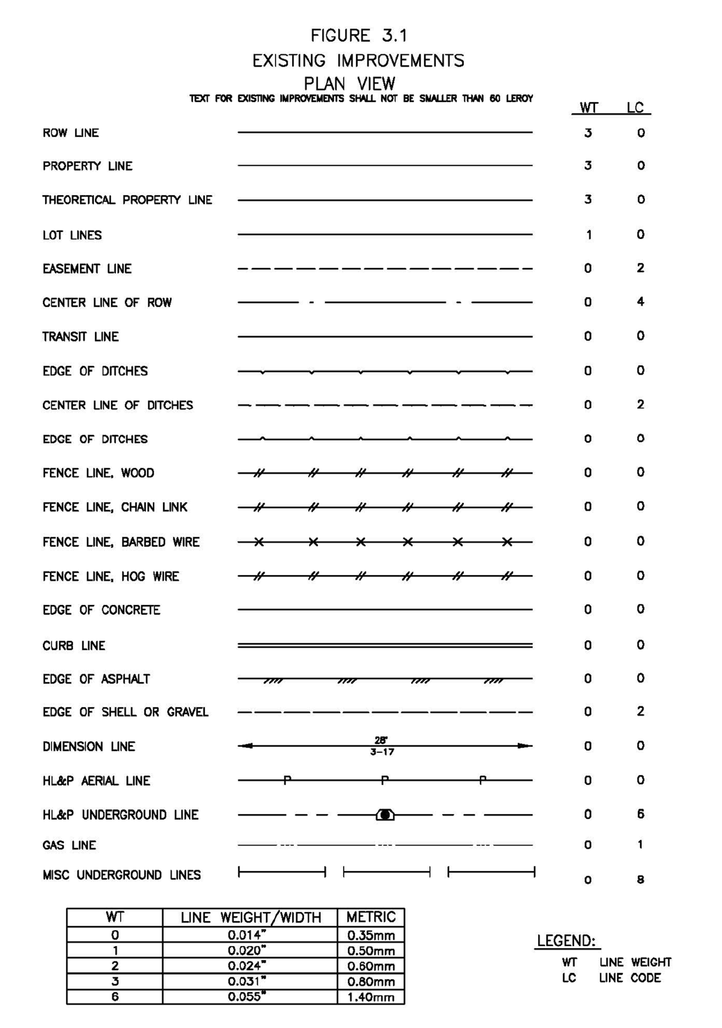

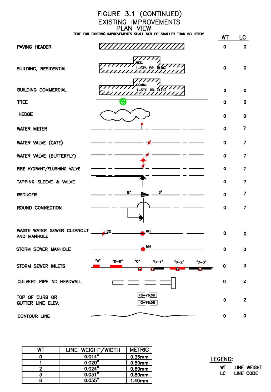
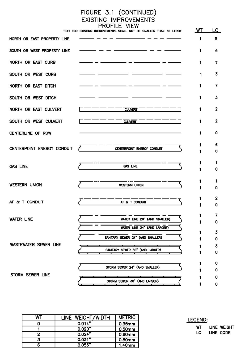
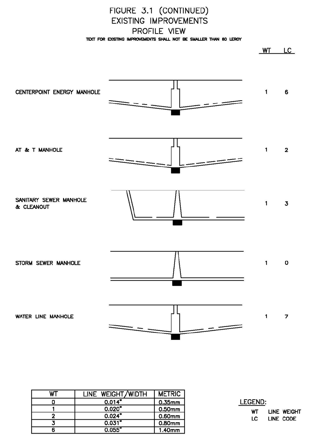
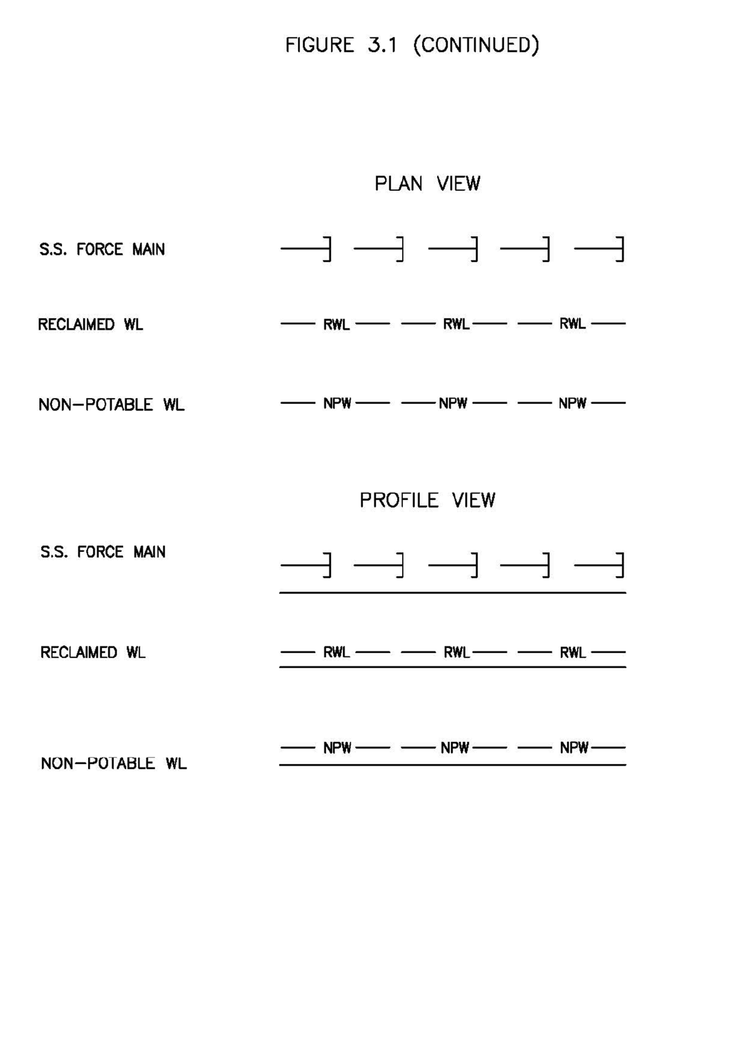
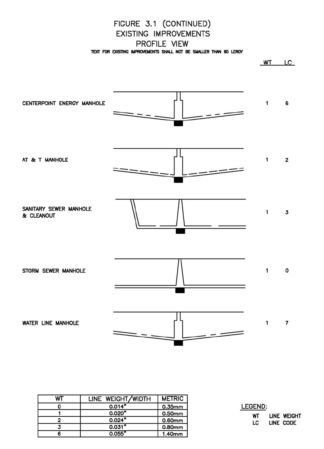
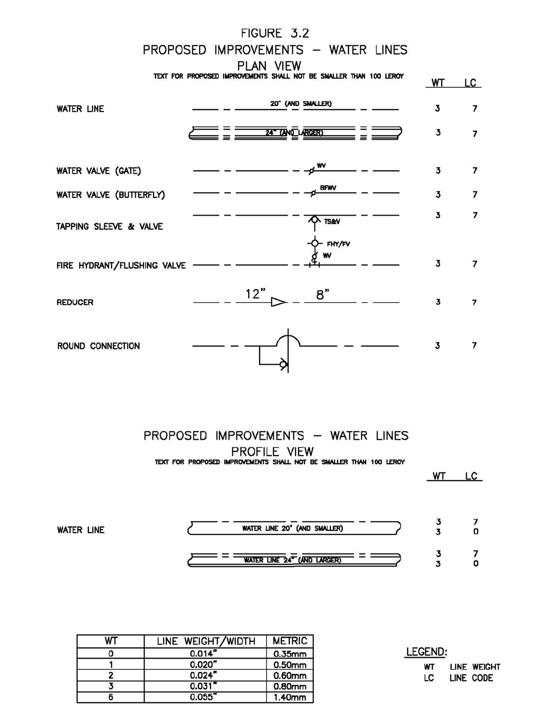
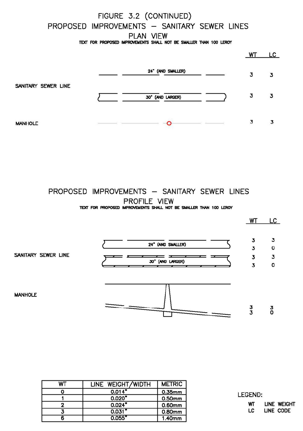
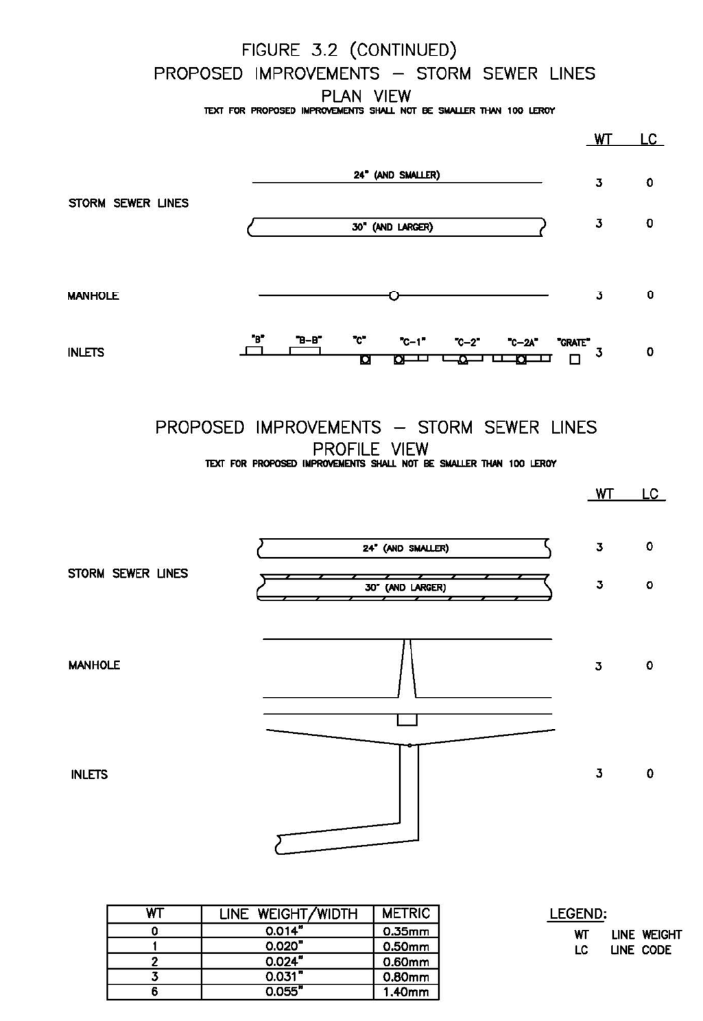
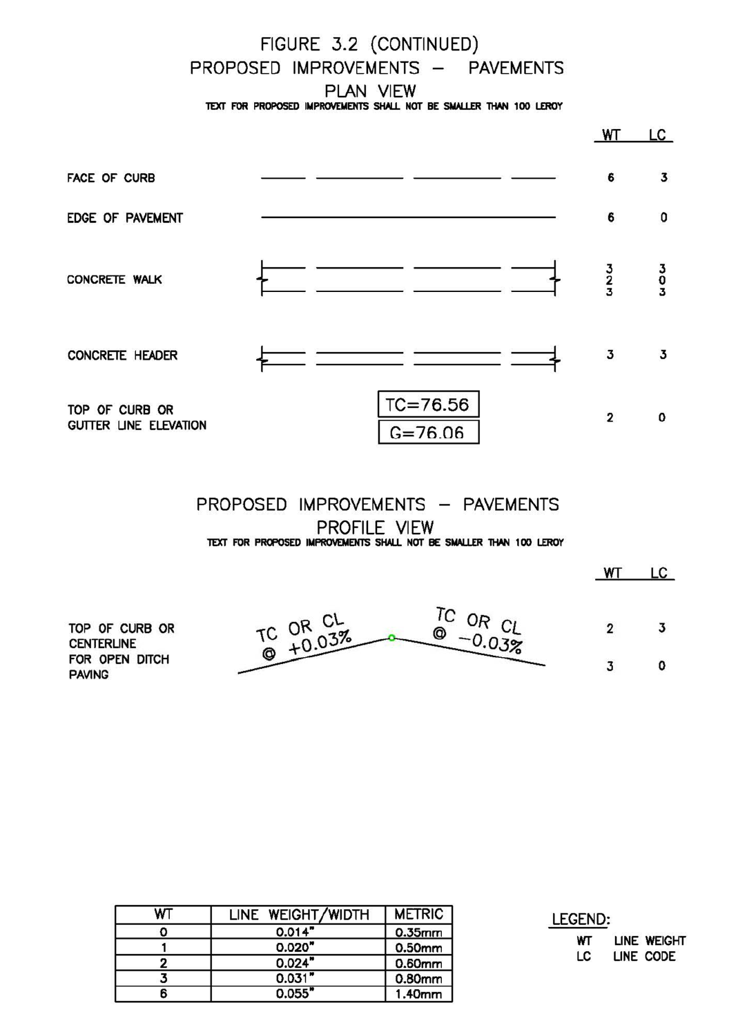
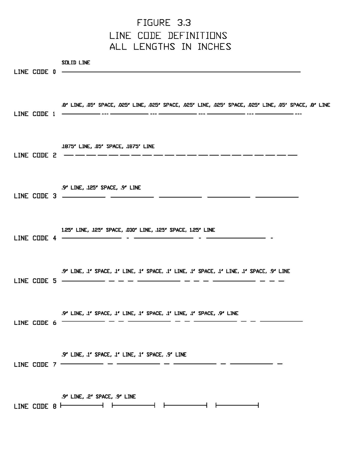

Appendix D
CONSTRUCTIONNOTESTOBE
ONALLPROJECTS
NO
DESCRIPTIONOFITEM
1 Water lines, wastewater collection systems, and storm drainage systems shall be
designedandconstructedinaccordancewiththeCITYOFHOUSTON’S,DEPARTMENT
OF PUBLIC WORKS AND ENGINEERING “DESIGN MANUAL, STANDARD
CONSTRUCTIONSPECIFICATIONS,ANDDETAILSFORWASTEWATERCOLLECTION
SYSTEMS,WATERLINES,STORMDRAINAGEANDSTREETPAVING”.
2 All storm sewer will be reinforced concrete (C76 Class III) and shall be installed,
bedded and backfilled in accordance with the City of Houston’s Drawings 02317‐02,
02317‐03,02317‐05,02317‐06and02317‐07asapplicable.
3 All storm sewers constructed in side lot easements shallbe R.C.P., minimum twenty
(20)footwideeasementsshallbeprovided.
4 An alternative to cement stabilized sand may be used as backfill for pipes fifty‐four
(54) inch and larger, from 1‐foot above the top of the pipe to the bottom of the
subgrade.Contractor may backfill with suitable material, provided the backfill
material is placed in eight (8)
inch lifts and mechanically compacted to ninety‐five
(95)% standard proctor density.Tests shall be taken at one hundred (100) foot
intervals oneach lift.Beddingand backfillto one (1) foot above the top of thepipe
shallbecement‐stabilizedsand .
5 Allproposedpipestub‐outsfrommanholesorinletsaretobepluggedwitheight(8)
inchbrickwallsunlessotherwisenoted.
6 Thecontractor(s)shall notifyHarrisCountyEngineering Department– PermitOffice
twenty‐four(24)hours inadvanceofcommencingutility and/orpavingconstruction
at (713) 274‐3823 and written notification forty‐eight (48) hours in advance of
commencingconstructionat10555NorthwestFreeway,Suite144,Houston,TX77092.
7 Paving shall be in accordance with the “Regulations of Harris County, Texas for the
ApprovalandAcceptanceofInfrastructure”and/oramendmentsofthesame.
8 Guidelines set forth in the latest edition of the “Texas Manual on Uniform Traffic
ControlDevices,TMUCDwithRevisions”shallbeobserved.
9 OWNER OR OWNER’S AGENT to obtain all permits required by the “Regulations of
HarrisCounty,TexasforFloodplainManagement”priortostartingconstruction.
10 OWNER OR OWNER’S
A
GENT to obtain all notifications required by Harris County,
Texaspriorto starting construction of utilitiesand/or culvertswithinHarrisCounty
andHarrisCountyFloodControlDistrictRights‐of‐Way.
PLEASEADDALLNOTESCIRCLEDINREDTOTHECONSTRUCTIONPLANS.

Appendix E
CONSTRUCTIONNOTESINVOLVINGUTILITIESANDPAVINGWORK
LOCATEDWITHINAPUBLICRIGHT‐OF‐WAY
NO
DESCRIPTIONOFITEM
1
NOTE: “Notifications Issued by Harris County Engineering
Department – PermitsOffice–is required for proposed work within
Harris County Right‐of‐Way. The project must be approved prior to
obtaining the required Notification. Be advised that a Notification
must be obtained separately from site development permit package.
For additional
information, please visit
http://www.eng.hctx.net/permits/Public‐Review‐Code/Public‐Plan‐
Review/Notification‐of‐Construction‐in‐the‐ROW or contact Public
ReviewInspectionsDepartment@(713‐274‐3931)”

Appendix F
CONSTRUCTIONNOTESFOR
ESPLANADEOPENINGS
A
NDTURNLANES
NO
DESCRIPTIONOFITEM
1 Esplanadenosesatthecrossoveraretobebullettype,paintedreflectorizedyellow,
inaccordancewiththeHarrisCountyPavementMarkingDetailandtobesixinches
(6”)thickwithsurfacecoloredblackforconcretepavementanduncoloredforasphalt
pavement,aminimumofsixfeet(6’)deepmeasured
fromtheendofthemediannose
andthecurbsareatleastfourfeet(4’)inwidthfacetoface.
2 The relocation of existing trees, landscaping, sprinkler systems, water meters, fire
hydrants, manholes, and pipelines (if applicable) are to be re‐installed as
recommendedbythe Harris CountyEngineering Department – PermitOfficeand/or
the Harris County Precinct (If located in Precinct 3, add note:Contractor(s) to
contact Precinct
3 Parks Administration Office @ (281‐531‐1592) two (2) weeks
priortoconstructionfortree(s)andlandscapingrelocation.
3 Existingreinforcedconcretepavementistobe machinesaw‐cut1‐1/2inchesdeepto
expose a minimum of twenty‐four (24) inches of reinforcing bars and place new
reinforcingbarstomatchexistingsteelsizeandspacingandtienewreinforcingbars
toexistingreinfor cingbarswitheighteen(18)
inchlaps.Fulldepthsaw‐cutmaybe
usedasanalternative.
4 Reinforcingconcretepavementistobeaminimumeight(8)incheswithaminimum
of5.0sackcementpercubicyard,[4500psiintwenty‐eight(28)days].Note:Dept h
ofconcretetomeetcurrentrequirementsofdepthofexisting pavementwheneverit
isgreater.
5 Asphalt turn lane to be minimum (2) inches H.M.A.C. with (10) inch base. Road
widening’sdoneonasphaltroadwaysforturnlanesmustbeoverlaidfullwidthofthe
roadwayfrombeginningtoendingtransition.
6 Subgrade shall be a minimum of six (6) inches for asphalt and eight (8) inches for
concrete,ofamaterial asspecifiedbytheengineerandapprovedby HarrisCounty,
and compacted to ninety‐five (95) percent standard proctor density (+/‐) two (2)
percentmoisture.Cementstabilizedsand,
asprescribedbyHarrisCounty specs,may
beusedasanalternative.
7 Slopeonproposedconcreteleftturnslotsistobeaminimumof1/8inchperfootwith
crownatcenterofesplanade.
8 All sewers under or within one (1) foot of proposed or future pavement shall be
backfilledwith1‐1/2sackcementstabilizedsandtowithinone(1)footofsubgrade.
9 ThecontractorshallnotifytheHarrisCountyEngineeringDepartment– PermitOffice
twenty‐four(24)hoursinadvanceofcommencingconstructionat(713)274‐3931and
writtennotificationforty‐eight(48)hoursinadvanceofcommencingconstructionfor
commercialandresidentialdevelopment.

Appendix F
CONSTRUCTIONNOTESFOR
ESPLANADEOPENINGSANDTURNLANES
NO
DESCRIPTIONOFITEM
10 Allpavementworkwillrequ ireanaccreditedlabcertificationforsubgrade,concrete
compressivestrength,inplacecore.Asphaltworkwillrequireasievetest,subgrade
andbasecompactionresults.
11 Pavingshall be in accordance withthe“Regulationsof HarrisCounty,Texasforthe
ApprovalandAcceptanceofInfrastructure”relating to the approval andacceptance
ofimprovementsinsubdivisionsorre‐subdivisionsand/oramendmentsofthesame.
12 Gu idelines set for in the “Manual on Uniform Traffic Control Devices” shall be
observed.
13 Include HarrisCountyDrawingSD‐1aspart oftheconstructionplans.
14 IncludeHarrisCountyPavementMarkingDetailasapartoftheconstructionplans.
15 NOTE: “Notification(s) issued by Harris County Engineering Department ‐ Permit
Officerequiredpriortoconstructionofutilities orturnlanes withinHarrisCounty
rights‐of‐way”.ContactHarrisCountyPermitOfficeat(713)274‐3931.
16 OWNER OR OWNER’S AGENTto obtain all permits and notification(s) required by
HarrisCounty,Texaspriortostartingconstructionofutilitiesand/orculvertswithin
HarrisCountyroadrights‐of‐way.
PLEASEADDALLNOTESCIRCLEDINREDTOTHECONSTRUCTIONPLANS.

Appendix G
CONSTRUCTIONNOTESFORALL
PROJECTSLOCATEDINTHE1%(100‐YEAR)FLOODPLAINAND.2%
(500‐YEAR)FLOODPLAIN
NO
DESCRIPTIONOFITEM
1 Allproposed constructionshall be in accordancewiththe “RegulationsofHarris
County,TexasforFloodplain Management”.
2 OWNER OR OWNER’S AGENT to obtain all permits requi red by Harris County,
TexaspriortostartingdevelopmentwithinHarrisCountyandHarrisCountyroad
rights‐of‐way.
Appendix H
IntensityDurationCurves
Region 3*
*Regions can be found in the Harris County Flood Control District Policy, Criteria, and Procedure Manual Reference Section
6.02.1.B. for design requirements.
Intensity,
Coefficient
50 % AEP 20 % AEP 10 % AEP 4 % AEP 2 % AEP 1 % AEP 0.2 % AEP
2-Year 5-Year 10-Year 25-Year 50-Year 100-Year 500-Year
Region 3
e 0.7244 0.6900 0.6623 0.6294 0.6096 0.5797 0.5196
b (in.) 48.35 52.32 54.68 57.79 61.00 60.66 62.17
d (min.) 9.07 7.88 6.96 5.89 5.46 4.44 2.95
AEP - annual exceedance probability
e
)( TCd
b
i
1.0
10.0
10 100
RainfallIntensity(in/hr)
TimeofConcentration,TC(min)
2Year
5Year
10Year
25Year
50Year
100Year
500Year
Appendix I
ButtonDetail For: KnuckleConfiguration
Appendix J
BenchmarkRequirements
Standards
New benchmarks arerequired to use the same criteria established during the Tropical
Storm Allison Recovery Project.The mark will be established using NAVD 1988, 2001
Adjustment Elevation and the GEOID 99 ellipsoid model to match the current Flood
InsuranceRateMapeffectiveJune18,2007.
Useasmuchaspossibledualfrequency,full‐wavelengthGlobalPositioningSystem(GPS)
receivers.TheNational GeodeticSurvey (NGS)2‐centimeter standard,as published in
NOAA Technical Memorandum NOS NGS‐58 dated November 1997 is the vertical
surveyingstandard.ThehorizontalstandardistheNGSSecondOrderClassIstandardas
published in the Federal Geodetic Control Committee (FGCC) document entitled
“Geometric Geodetic Accuracy Standards and Specifications for Using GPS Relative
PositioningTechniques”datedAugust1,1989.InareaswhereitisimpossibletouseGPS
duetoconditionssuchasobstructedskyvisibility,precisedifferentiallevelingisrequired
toconnectsuchobstructedbenchmarkstotherestofthenetwork.Differentialleveling
will be used to meet the maximum loop misclosure specifications for the NGS Second
Order Class II vertical stand for leveling, as published in the FGCC document entitled
“StandardsandSpecificationsforGeodeticControlNetworks”datedSeptember1984.
The control will meet the NGS Classification system for Range VI positions.Range VI
indicatesthat thesepositions meetthe 0.02meter00.05 meterAccuracy Standard for
HorizontalPosition,EllipsoidalHeight,andOrthometricHeight(elevation)andthe95%
confidencelevel.
SurveyControl
The controls to be used are the Continuously Operating Reference Stations (CORS)
monitored
byNGS.TheCORSstationslocatedatextensometersitesareconstructedso
astobeunaffectedbythe subsidenceof thegroundaroundthem.Theyareconsidered
by HGCSD and others to be the most stable control monuments in Harris County.The
threeCORSsitesareasfollows:
PIDAJ6426
ADDICKS1795CORSARP(ADKS)
PIDAJ6430NORTHEAST2250CORSARP(NETP)
PIDAF9521LAKEHOUSTONCORSARP(LKHU)
PID=PermanentIdentifier
ARP=AntennaReferencePoint(physicalbottomoftheantenna)
The1997.00EpochDatewillbereferencedtocoincidewiththeexistingnetwork.

BenchmarkConstruction
Abrassdisk,providedbyHarrisCountyFloodControlDistrict,shallbesetinadrilled
holeintheconcreteonapermanentstructureandfastenedwithepoxycementor
establishedasapermanentmonument.AReferenceMarkNumberwillbeassignedto
yournewmonument.StampthenewdiskwiththenewlyassignedReferenceMark
Number.
BenchmarkAcceptance
ReferenceMarksubmittalformscanbeobtainedfromtheHarrisCountyPermitsOffice
ordownloadedfromthewebsite,http://www.eng.hctx.net/permits.ATexasState
RegisteredProfessionalLandSurveyorisrequiredtoset,levelandsubmitfor
acceptancenewbenchmarks.Submittwo(2)papercopiesandthedigitalfileofthe
fullycompletedformstotheHarrisCountyPermitsOffice.Afteracceptance,the
benchmarkinformationwillbeuploadedtotheHarrisCountybenchmarkwebsitefor
publicuse.
APPENDIX K
UNIFORMSTANDARDSFORPUBLICSTREETNAMING
Thisappendixiswrittentoprovideclarificationtothestreetnamingstandardsin
HarrisCounty.Uniformityinstreetnameselectionisessentialtopublicsafetyasit
reducesconfusiontothegeneraltravelingpublic,andmostimportantlyreduces
confusiontotheemergencyserviceproviders.
PRINCIPLES:
Publicstreetnamingshallfollowtheseprinciples:
1. Namedinamannerthatreducesconfusiontothetraveler,utilityproviders,
addressingauthority,andmostimportantlytheemergencyserviceprovider.
2. Whenlocatedwithin,orpartiallywithinaMunicipalityoritsExtraterritorial
Jurisdiction(ETJ),streetnameselectionshallfollowtheguidelinesfornaming
streetsenactedbythatMunicipality.
3. “OneStreet–OneNamePrinciple”‐Maintainsthesamenamefortheentire
limitsofthestreet.
a. Whenpresentedtheopportunitythroughastreetlimitextensionorother
improvements,theCountyEngineerwill,whenable,requirestreetname
uniformityfortheentirelimitsofthestreetwhereitdoesnotcurrently
exist.
b. Regardlessofplannedimprovements,ifatanypointasafetyconcernis
discoveredduetonon‐uniformity,theCountyEngineermayrecommend
changingthestreetnametofacilitateuniformityandsafety.
4. Allstepsnecessarytochangeastreetnamewillbeexecutedbytheapplicant.
GUIDELINES:
Ingeneral,tomeetthethreeprinciplesoutlinedabove,thefollowingareguidelinesfor
namingstreetswithinHarrisCounty:
1. Anewstreetthatisanextensionofanexistingstreetormasterplannedstreet
shallhavethesamenameastheexistingstreet.
2. Anon‐publicstreetthatisadirectextensionofapublicstreetoracul‐de‐sac
shallnothavethesamenameasthepublicstreet.
3. Adirectionalprefixorsuffixmaybeusedtoclarifythegenerallocationofa
street,providedthattheuseofthedirectionalprefixorsuffixisconsistentwith
theestablishednamingconventionwithintheareainwhichthestreetexists.
4. Streetnamesuffixesshallbelimitedtothefollowinguses:
a. “Circle”,“Court”and“Loop”shallbeusedonlytodesignatestreetsthat
terminateatacul‐de‐sacorareconfiguredasageometricallyloopedstreet.
b. “Boulevard”,“Crossing”,“Crossroad,“Expressway”,“Motorway”,
“Parkway”,“Speedway”or“Throughway”shallbeusedonlytodesignate
majorthoroughfares,majorcollectorstreets,collectorstreetsorother
streetsdesignedtohandletrafficvolumesinexcessofnormalneighborhood
trafficgenerationorthatareboulevardsections(i.e.mediandivided)with
atleasttwolanesoftrafficineachdirection.
c. “Bypass”,“Expressway”,“Freeway”and“Highway”shallbeusedonlyto
designatehighwayorfreewayssubjecttojurisdictionofthestate
departmentoftransportation.
d. “Avenue”,“Drive”,“Road”,and“Street”shallbeusedonlytodesignate
majorthoroughfares,majorcollectorstreets,collectorstreets,orlocal
streets.
e. “Bridge”,“Fork”,“Lane”,“Oval”,“Passage”,“Path”,“Place”,“Trail”and
“Way”shallbeusedonlytodesignatecollectorstreetsorlocalstreets.
f. “Tunnel”shallbeusedonlytodesignatestreetsthatprovideunderground
orunderwaterpassage.
g. Astreetnamesuffixshallnotbeusedaspartofthestreetname.
h. TheabbreviationofastreetnamesuffixshallbeconsistentwiththeUnited
StatesPostalServicepostaladdressingstandards.
5. Astreetnameshallnotincludeanytypographiccharactersorsymbols.
6. Analphabeticalornumericalstreetnameshallnotbeusedtonameanewstreet
unlessthenewstreetisadirectextensionofanexistingstreetwithan
alphabeticalornumericalnamethatisnotduplicativeofanexistingstreetname.
7. Whenastreetchangeshorizontaldirectionbyapproximately90degrees,the
streetnameshallchange.
Forpurposesofthesection,thetermscul‐de‐sac,collectorstreet,andlocalstreetshall
havethemeaningsassignedtothosetermsbytheFederalHighwayAdministration
(FHWA)and/orAmericanAssociationofStateHighwayandTransportationOfficials
(AASHTO)“APolicyonGeometricDesignofHighwayandStreets”.
EXEMPTIONS
ForstreetslocatedinanExtraterritorialJurisdictionofamunicipality,theCounty
Engineerwill
reviewrequestsforexceptionsonlyafterwrittenapprovalforthe
exceptionfromtheMunicipalityisobtainedbytheapplicant.Inlocationswithout
ExtraterritorialJurisdiction,requestsforexceptionswillfollowtheproceduresoutlined
withintheHarrisCountyInfrastructureRegulations.
